
Big Island Hikes
Big Island Hiking at a Glance
Few places on Earth pack as many kinds of hiking into one island as the Big Island of Hawaiʻi. This is an island you can walk from a steaming crater floor to a 13,803-foot summit, from rainforest waterfall loops to dry desert lava fields, often within a single day of driving. The variety comes from the island’s size and its five volcanoes: each mountain builds its own weather, and the weather builds everything the trails cross.
The honest starting point is that Big Island hiking is not like hiking most tropical islands. Distances are long, the island is large, and trails cluster in a handful of regions rather than lining the coast. Plan around bases, not beaches. If you want volcano trails, stay near Volcano Village. If you want the Kohala coast and valleys, stay in Waimea or along the Kona coast. Driving between the island’s hiking hubs takes an hour or more each way, so it is better to pick one region per day than to chase trails across the island.
Trail difficulty here is shaped by forces that surprise first-time visitors. Altitude is one: trails on Saddle Road start near 6,700 feet, and the Mauna Kea summit trail climbs past 13,000 feet, where every step feels heavier. Heat is another: low-elevation lava fields around Kona can be brutally hot by mid-morning, with no shade and dark rock radiating heat back at you. And the volcanic landscape adds its own challenges: razor-sharp pāhoehoe and ʻaʻā lava tear up shoe soles and skin, steam vents appear without warning near active areas, and rain can turn a dusty path into slick mud within minutes.
The good news is that the Big Island also offers some of the most rewarding easy walks in Hawaiʻi. The ʻAkaka Falls loop is a paved 0.4-mile stroll through rainforest to one of the island’s most famous waterfalls. The Devastation Trail in Hawaiʻi Volcanoes National Park is a flat mile across a landscape shaped by a 1959 eruption. Kipuka Puʻu Huluhulu on Saddle Road is a 0.6-mile loop through protected native forest with panoramic views. You do not need to be a mountaineer to have a great hiking day here; you only need to match the trail to your fitness and the day’s weather.
One practical note applies to nearly every trail on this page: conditions change. Eruption activity redirects trails and closes areas in Hawaiʻi Volcanoes National Park. Waipiʻo Valley’s road has been closed to visitors since February 2022 under a county emergency rule. Hot springs, lava viewing, and crater access all shift with the volcanoes. Check the National Park Service, the Hawaiʻi Division of State Parks, and Hawaiʻi County for current status before you set out, and never trust an old guidebook or an old blog post on access rules.
The Best Hikes on the Big Island
Kīlauea Iki Trail
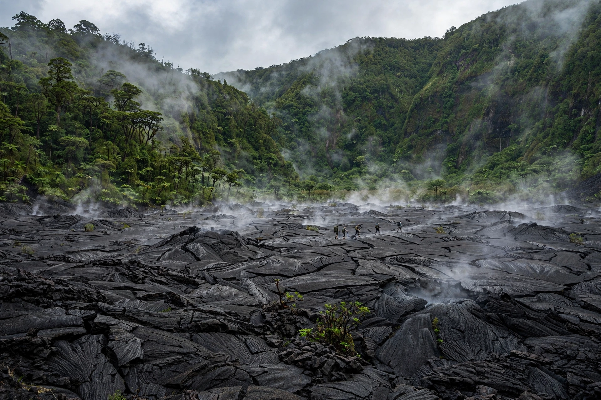
The Kīlauea Iki Trail is the single best hike on the Big Island, and it is not close. This 3.3-mile loop drops 400 feet from the crater rim into Kīlauea Iki Crater, crosses the still-steaming floor of a lava lake formed in the 1959 eruption, and climbs back out through rainforest. The National Park Service rates it moderate and estimates two to three hours. The crater floor crossing is the unforgettable part: the trail is marked by ahu, stacked lava-rock cairns, and you walk across a landscape of cracked black crust with steam rising from ground cracks and ʻōhiʻa lehua trees pushing through the fissures.
The eruption that built this landscape began on November 14, 1959, and ran through seventeen eruptive episodes over five weeks. One lava fountain reached 1,900 feet, the tallest ever recorded in Hawaiʻi. More than 84 million gallons of lava pooled in the crater, raising the lake floor by 400 feet. Walking across it today, with the crater walls rising on every side, is one of the most humbling outdoor experiences in the islands.
Start at the Kīlauea Iki Overlook on Crater Rim Drive. The park recommends the counterclockwise route, to your right from the overlook, which descends through forest to the crater floor and returns along the far rim. The descent is short but steep, with uneven steps. Carry water, wear sturdy shoes, stay on the marked trail, and keep away from ground cracks and cliff edges. Combine it with the Thurston Lava Tube spur for a longer walk if your legs are willing.

Pololū Valley Trail
The Pololū Valley Trail is the Big Island’s classic coastal valley hike. It drops about 420 feet in roughly half a mile from the Pololū Valley Lookout at the end of Highway 270 to a black-sand beach on the valley floor. The descent takes about 20 minutes; the climb back up takes 30 or more, and it is steep, often muddy, and lined with switchbacks and loose gravel. Rated moderate, the trail is manageable for reasonably fit hikers but strenuous on the return for many.
The payoff is a wild, remote-feeling beach backed by some of the most dramatic sea cliffs in Hawaiʻi. Pololū was once farmed intensively by Native Hawaiians and later by rice growers, and the valley still holds that deep agricultural history. There are no facilities at the lookout or in the valley, so bring water and snacks; the nearest restrooms are in Hāwī, about 8 miles back. The lookout parking lot is small and fills early, and hikers park along the roadside. Go early in the morning for the best light and the coolest temperatures.
Kipuka Puʻu Huluhulu (Saddle Road)
Not to be confused with the Puʻu Huluhulu inside Hawaiʻi Volcanoes National Park, this Puʻu Huluhulu sits on Saddle Road at the 28-mile marker, directly across from the Mauna Kea Access Road. Puʻu huluhulu means “hairy hill,” and the cinder cone rises about 200 feet out of the surrounding lava flows as a kīpuka: an older, vegetated hill that lava flowed around instead of over. The result is a protected native-tree sanctuary rich in rare Hawaiian plants and birds.
The loop trail is only about 0.6 miles with roughly 200 feet of elevation gain, taking 30 to 40 minutes at an easy pace. Fences and gates protect the sanctuary from feral goats and pigs; close every gate behind you. The summit offers panoramic views of Mauna Loa, Mauna Kea, and the sweep of lava fields below. It is a perfect stop in the middle of a Saddle Road crossing, and a good way to test how your body handles altitude before committing to anything higher. Note that the cone drew national attention beginning in July 2019 as a gathering point for demonstrations related to the Thirty Meter Telescope; the area’s cultural and political significance is real, and visitors should treat it with respect.
ʻAkaka Falls Loop
The ʻAkaka Falls loop in ʻAkaka Falls State Park is the Big Island’s best easy hike. The paved 0.4-mile loop winds through lush rainforest, past bamboo groves and wild orchids, to an overlook of ʻAkaka Falls plunging 442 feet into a fern-covered gorge. The loop also passes Kahūnā Falls. The trail is gentle, takes 20 to 30 minutes, and is suitable for almost all fitness levels. Go early to beat the tour buses, and remember that the park is a day-use fee area with no swimming permitted.
Devastation Trail
The Devastation Trail in Hawaiʻi Volcanoes National Park is a flat, paved one-mile walk across a landscape buried by the 1959 Kīlauea Iki eruption. Cinder and ash from the eruption’s fountains devastated the forest here, and the trail crosses the recovering landscape with views of the crater and the cinder cone Puʻu Puaʻi. It is an easy, educational walk and a good pairing with the Kīlauea Iki Trail on the same day.
Kalōpā State Recreation Area
Kalōpā State Recreation Area, on the Hāmākua Coast near Honokaʻa, protects one of the finest remaining native ʻōhiʻa and koa forests on the island. The park’s trail network winds through the forest on paths of varying length, from short nature walks to longer loops. Because the forest canopy is intact, the trails stay cool and shaded even on warm days, and the birdlife is excellent. Kalōpā is also one of the island’s best picnic and camping spots, and it pairs naturally with a Hāmākua Coast waterfall day.
Volcano Hikes
Hawaiʻi Volcanoes National Park is the heart of Big Island hiking, with more than 150 miles of trails crossing lava fields, rainforests, craters, and coastlines. The park’s trails are also the most condition-sensitive on the island: eruptions, gas emissions, and earthquakes close and reopen routes, sometimes with little notice. Always check the park’s current alerts before planning a volcano hiking day.
Kīlauea Iki Trail (3.3 miles, moderate, 2 to 3 hours) is covered above and remains the park’s essential hike. The Crater Rim Trail offers flexible segments along the edge of Kīlauea Caldera, including the stretch from the Kīlauea Iki parking lot toward Volcano House (about 1.4 miles one way), with views across the caldera and steam vents. Sections of the rim trail have been closed at times due to volcanic gas, so check which segments are open.
Puʻu Huluhulu via the Nāpau Crater Trail (about 2.6 miles round trip, moderate) starts from the Mauna Ulu parking area on Chain of Craters Road and crosses the 1973 to 1974 lava flows to a forested cinder cone with views of Mauna Loa, Mauna Kea, and the ocean on clear days. The terrain is rough volcanic rock, and the hike is best done in the cooler morning hours with sturdy footwear and sun protection.
Devastation Trail (1.0 mile one way, easy) crosses the 1959 eruption’s footprint, as described above. For a longer crater experience, the Kīlauea Iki Overlook to Nāhuku (Thurston Lava Tube) connector lets you extend the classic loop with a walk through a 600-foot-long lava tube formed by a river of lava that crusted over while molten rock continued flowing beneath.
A note on eruption viewing: the park’s trails sometimes offer views of active lava, and sometimes they do not, depending entirely on the current eruption. The park does not guarantee lava viewing, and approaching active lava outside designated viewing areas is dangerous and illegal. If an eruption is underway, follow ranger guidance and posted closures exactly. The evergreen rule applies: check the USGS Hawaiian Volcano Observatory and the National Park Service for current conditions.
Coastal and Valley Hikes
Pololū Valley
Covered in detail above, the Pololū Valley Trail is the Big Island’s signature valley hike: steep, short, muddy, and spectacular. Respect the valley. Stay on the trail, pack out everything you bring, and remember that Pololū is a place of deep cultural significance, not just a photo stop.
Waipiʻo Valley: An Honest Note
Waipiʻo Valley, the famous “Valley of the Kings,” would normally headline any Big Island valley-hiking list. It cannot, honestly, right now. The Waipiʻo Valley Road has been closed to visitors since February 2022 under a Hawaiʻi County emergency rule that has been renewed repeatedly. Pedestrians, ATVs, and horseback riders are prohibited on the road, and the valley floor is reachable only through permitted shuttle tours. The free Waipiʻo Valley Lookout at the top of the road remains open and offers the classic view across the mile-wide valley to the sea cliffs and black-sand beach. Do not trust older guidebooks or blog posts that describe hiking into the valley; the closure is real and enforced. Check Hawaiʻi County for the current status before you go.
Puʻu Waʻawaʻa
Puʻu Waʻawaʻa, on the Kona side north of Kailua-Kona, is a cinder cone rising from dryland forest in the Puʻu Waʻawaʻa Forest Reserve. The Na Ala Hele trail system here climbs through one of the island’s important dry-forest restoration areas, where native plants are being brought back after centuries of grazing. The summit rewards hikers with sweeping views of Hualālai, the Kona coast, and on clear days the neighboring islands. This is a hot, dry, exposed hike: start early, carry more water than you think you need, and wear sun protection. The dry forest here is ecologically precious, so stay on the trail and leave no trace.
Kohala Coast and Hāmākua
The Kohala region offers several shorter coastal walks beyond Pololū. The Lapakahi State Historical Park trail near Hāwī winds through a 262-acre coastal archaeological site, combining a rugged shoreline walk with ancient Hawaiian fishing-village remains. On the Hāmākua Coast, the Onomea Bay trails near Papaikou thread through lush coastal forest to quiet coves. These are gentler walks than the valley descents, and they pair well with the coast’s waterfall stops.
Hiking Safety
Big Island trails demand more respect than their distances suggest. The main hazards are heat, altitude, volcanic gases, and sudden weather changes.
Heat and sun. Low-elevation lava-field hikes around Kona and the Saddle Road area can be brutally hot by mid-morning. Dark lava absorbs and radiates heat, shade is nonexistent, and the trade winds that cool the coasts do not always reach inland trails. Start early, carry at least a liter of water per person for short hikes and far more for long ones, wear a hat and sunscreen, and turn back if anyone in your group feels dizzy or nauseated.
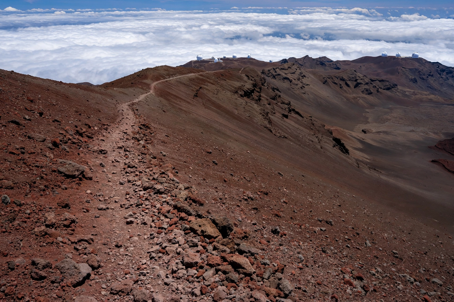
Altitude. The Saddle Road trails start near 6,700 feet, and the Mauna Kea Humuʻula Trail climbs from about 9,200 feet at the visitor center to 13,803 feet at the summit. That is roughly 4,600 to 4,800 feet of gain over about 6 to 7 miles each way, taking most hikers 7 to 10 hours round trip. Altitude sickness is a real risk: headaches, nausea, and fatigue can strike even fit hikers. Ascend slowly, hydrate, and descend immediately if symptoms worsen. The Puʻu Huluhulu loop on Saddle Road is a sensible acclimatization walk before attempting anything higher.
Volcanic gases and steam. In Hawaiʻi Volcanoes National Park, sulfur dioxide and other volcanic gases can reach hazardous levels, especially near active vents and downwind of eruptions. Heed all posted closures; they exist because the gas is genuinely dangerous, not as a formality. Stay on marked trails, keep away from ground cracks and steam vents, and leave immediately if you smell strong sulfur or have trouble breathing.
Flash floods and slippery trails. Windward trails like Pololū and the Hāmākua waterfall paths get heavy rain. Trails turn slick fast, stream crossings can rise without warning, and valley trails are the most exposed. Check the weather, never cross a flooding stream, and wear shoes with real traction rather than flip-flops or smooth-soled sneakers.
Lava rock. Both pāhoehoe (smooth, ropy) and ʻaʻā (jagged, clinkery) lava will shred skin and shoe soles. Sturdy closed-toe hiking shoes are non-negotiable on lava terrain. Watch every step on uneven ground, and do not climb on unstable formations or near cliff edges and sea cliffs.
Best Time and What to Bring
The Big Island’s trails are hikeable year-round, but conditions vary by season and elevation. Winter (November through March) brings the heaviest rain to windward trails like Pololū and the Hāmākua Coast, making paths muddier and stream crossings higher, while the Kona side stays relatively dry. Summer (April through October) is hotter at low elevations but drier and more predictable on most trails. Morning is almost always the best time to hike: cooler temperatures, calmer winds, fewer crowds, and better light for photography.

Mauna Kea’s summit can be near freezing at any time of year, and winter storms can bring snow and ice to the summit road and trail. If you are attempting the Humuʻula Trail, check the summit weather forecast specifically, not the beach forecast, and carry warm layers, gloves, and a wind shell regardless of the season.
Pack for the trail you are actually hiking, not the beach you visited yesterday: sturdy closed-toe shoes, more water than you expect to need, sun protection, a rain layer for windward hikes, warm layers for anything above 6,000 feet, snacks, a charged phone, and a basic first-aid kit. Tell someone your plan, especially for remote trails like the Mauna Kea summit route. And remember that there is no shame in turning back: the island’s trails will still be there tomorrow.
Frequently Asked Questions
What is the best hike on the Big Island?
The Kīlauea Iki Trail in Hawaiʻi Volcanoes National Park is the consensus best hike: a 3.3-mile moderate loop that crosses the floor of a steaming crater formed in the 1959 eruption. It takes two to three hours and suits most reasonably fit hikers.
Can you hike into Waipiʻo Valley?
Not currently. The Waipiʻo Valley Road has been closed to visitors since February 2022 under a county emergency rule, and pedestrians are prohibited. The valley floor is reachable only through permitted shuttle tours. The lookout at the top of the road remains open. Check Hawaiʻi County for the current status.
How hard is the Mauna Kea summit hike?
Very hard. The Humuʻula Trail runs about 12 to 14 miles round trip with roughly 4,600 to 4,800 feet of elevation gain, climbing from 9,200 feet to 13,803 feet. Most hikers need 7 to 10 hours. Altitude sickness is a serious risk, and the summit can be near freezing. It is an experts-only undertaking that demands preparation, fitness, and respect for the mountain’s cultural significance.
Are there easy hikes on the Big Island?
Yes. The ʻAkaka Falls loop is a paved 0.4-mile rainforest stroll. The Devastation Trail in the national park is a flat one-mile walk. The Kipuka Puʻu Huluhulu loop on Saddle Road is 0.6 miles through native forest. These are all suitable for families and casual walkers.
Do you need a permit to hike on the Big Island?
Most trails require no permit. Hawaiʻi Volcanoes National Park charges a per-vehicle entrance fee. The Mauna Kea Humuʻula Trail asks hikers to register at the visitor center. Some state and county parks charge parking or entry fees. No special backcountry permit system applies to the trails on this page, but always verify current rules before you go.
Is it safe to hike near active lava?
Only in designated, open areas and only by following ranger guidance exactly. Volcanic gases, unstable ground, and sudden eruptive changes make off-trail lava areas genuinely dangerous. The park does not guarantee lava viewing, and approaching active lava outside designated areas is illegal. Check the USGS Hawaiian Volcano Observatory for current activity.
What should I wear hiking on the Big Island?
Sturdy closed-toe hiking shoes with good traction, moisture-wicking clothing, a hat, and sunscreen for low elevations; warm layers, gloves, and a wind shell for anything above 6,000 feet, especially Mauna Kea. Bring a rain layer for windward trails. Never hike lava terrain in sandals or flip-flops.
Can you hike the Big Island without a car?
Realistically, no. Trailheads are spread across the island, public transit does not reach them, and rideshares are unreliable outside the resort areas. A rental car is effectively essential for any Big Island hiking trip.
Related Guides
Keep exploring the Big Island’s outdoors with these companion guides:
- Big Island Hawaiʻi Waterfalls: ʻAkaka Falls, Rainbow Falls, Hiʻilawe, and waterfall safety.
- Hawaiʻi Volcanoes: Kīlauea, Mauna Loa, and eruption science.
- Where Is the Big Island in Hawaiʻi: Complete Guide: the island’s position, regions, and airports.
- Big Island Hawaiʻi Weather: microclimates that shape every hike.
- Hāwī, Hawaiʻi: the North Kohala town nearest the Pololū trailhead.
- Hawaiʻi Waterfalls: the statewide waterfalls hub.
- Best Time to Visit Hawaiʻi: seasons, weather, and trip timing.
- Hawaiʻi Map: orient yourself before you drive to the trailhead.
A Final Note
The Big Island’s trails reward hikers who prepare honestly and walk respectfully. This is an island still being built by its volcanoes, and its trails cross landscapes that are young, fragile, and in some places sacred. The best hiking day here is not necessarily the longest or the hardest; it is the one where the trail matched your fitness, the weather cooperated because you checked it, and you left the place exactly as you found it. Walk the crater floor in the morning light, stand at the Pololū lookout while the clouds lift, breathe the cool air of the Kalōpā forest, and let the island set the pace. The trails will do the rest.