
Puna, Hawaiʻi
In This Guide
Puna at a Glance
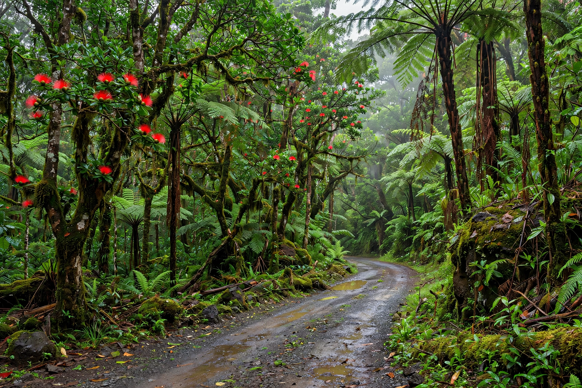
Puna is the largest and fastest growing district on the Island of Hawaiʻi, stretching across the island’s lower eastern flank from the slopes of Kīlauea down to a wild coastline of black sand, lava cliffs, and tide pools. If Kona is the Big Island’s sunny resort face and Hilo its rainy garden city, Puna is the island’s untamed frontier: rainforest roads lined with ʻōhiʻa lehua and hapuʻu tree ferns, steam rising from cracks in the ground, and a coastline still being shaped by lava.
The district sits squarely on the East Rift Zone of Kīlauea, which makes it both one of the most geologically dynamic places in Hawaiʻi and one of the most affordable places to live on the island. That combination has given Puna a distinct character. It is rural, alternative, and fiercely independent. Farmers markets, off-grid homesteads, lava tube skylights, and small towns like Pāhoa sit side by side with landscapes that look like they were born yesterday, because some of them nearly were.
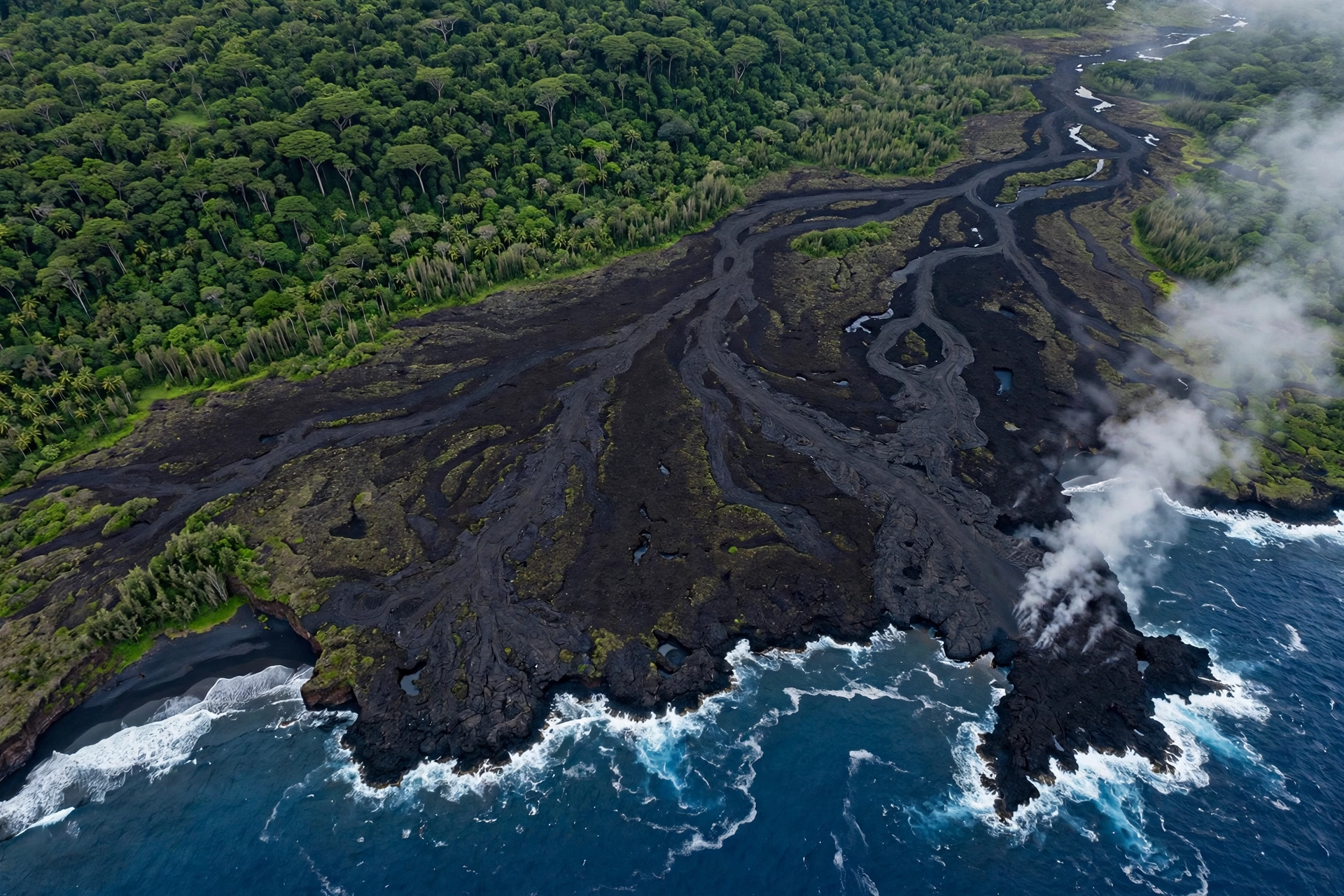
Visitors come to Puna for what they cannot find anywhere else in the state: lava tree molds standing like stone sentinels in a forest, a brand new black sand beach built by the 2018 eruption, warm ocean tide pools heated by volcanic activity, and the raw feeling of standing on ground that is still, geologically speaking, under construction. It is not a polished resort district. Roads can be rough, rain is frequent, and cell service drops out in places. But for travelers who want the Big Island at its most elemental, Puna delivers.
A word of honesty before you plan: Puna is an active volcanic landscape, and conditions change. Eruption activity, road closures, park access, and the status of hot springs and beaches can all shift with little warning. Always check the USGS Hawaiian Volcano Observatory and Hawaiʻi County official sources for current conditions before you go, and treat every piece of specific access advice in this guide as a starting point to verify.
History and the 2018 Eruption
Puna’s story begins long before written records. The district was one of the first areas of the Big Island settled by Polynesian voyagers, and its name is said to mean “spring” or “well,” a reference to the fresh water found in its springs and lava tubes. Ancient Hawaiians farmed the fertile volcanic soils, fished the rich coastline, and built heiau, or temples, including some of the island’s most significant religious sites. The district’s spiritual importance endures: Pele, the volcano deity, is deeply associated with this landscape, and many residents, Native Hawaiian and otherwise, speak of the land here with genuine reverence.
In the 19th century, Puna followed the familiar arc of plantation Hawaiʻi. Sugar plantations and later papaya and orchid farms drew immigrant laborers from Japan, the Philippines, Portugal, and elsewhere, and small mill towns grew up around them. Pāhoa, the district’s main town, retains its wooden plantation-era storefronts to this day. When sugar declined in the late 20th century, land in Puna became some of the cheapest in the state, and the district began attracting newcomers: artists, farmers, retirees, and people seeking an alternative to resort Hawaiʻi. That influx created the Puna of today, a patchwork of subdivisions, farms, and forest that is at once rural and surprisingly populous.
Then came 2018. In late April of that year, the floor of Puʻuʻōʻō crater on Kīlauea’s East Rift Zone collapsed, and magma began moving underground toward lower Puna. On May 3, fissures opened in the Leilani Estates subdivision, and over the following three months, 24 fissures erupted in a residential area, sending fountains of lava hundreds of feet into the air and rivers of molten rock toward the sea. The eruption destroyed more than 700 homes, displaced thousands of residents, covered roads and farmland, and filled in Kapoho Bay entirely. Fissure 8, the most productive vent, built a new cinder cone and sent lava all the way to the ocean, where it created nearly a mile of new coastline and the brand new black sand beach at Pohoiki.
The human cost was enormous, and it deserves to be stated plainly. Families lost homes that can never be rebuilt on the same ground. Neighborhoods vanished under tens of feet of rock. The recovery is still ongoing years later, and many residents carry the experience with them. Visitors should approach the eruption zone with respect, not disaster tourism curiosity. Do not trespass on private property, do not treat destroyed neighborhoods as photo opportunities, and understand that for the people who live here, 2018 was not an attraction. It was the defining event of their lives.
Geologically, the eruption was a reminder of something fundamental: Puna is one of the few places on Earth where you can watch an island being built in real time. The 2018 flows added hundreds of acres of new land to the Big Island. That new land is stark, black, and slowly being colonized by the first pioneer plants. Walking its edges, where rainforest meets fresh lava, is one of the most striking experiences in all of Hawaiʻi, and it is available to anyone willing to drive the back roads of lower Puna.
What to See and Do
Pāhoa Town
Pāhoa is Puna’s beating heart: a small, funky town of wooden false-front buildings that looks like a frontier settlement and behaves like an artists’ colony. The main street holds galleries, bookshops, health food stores, secondhand shops, and some of the best casual eating on the east side of the island. The town hosts a well known farmers market, and on weekends the streets fill with vendors, musicians, and locals. It is the natural base for exploring lower Puna, with the district’s best concentration of food, supplies, and local knowledge.
Pāhoa sits just a few miles from the 2018 eruption zone, and the town became the staging ground for the emergency response. Residents will talk about those months if you ask respectfully, and listening is worth more than any viewpoint. Support the town by eating, shopping, and staying here rather than just passing through.
Lava Tree State Monument
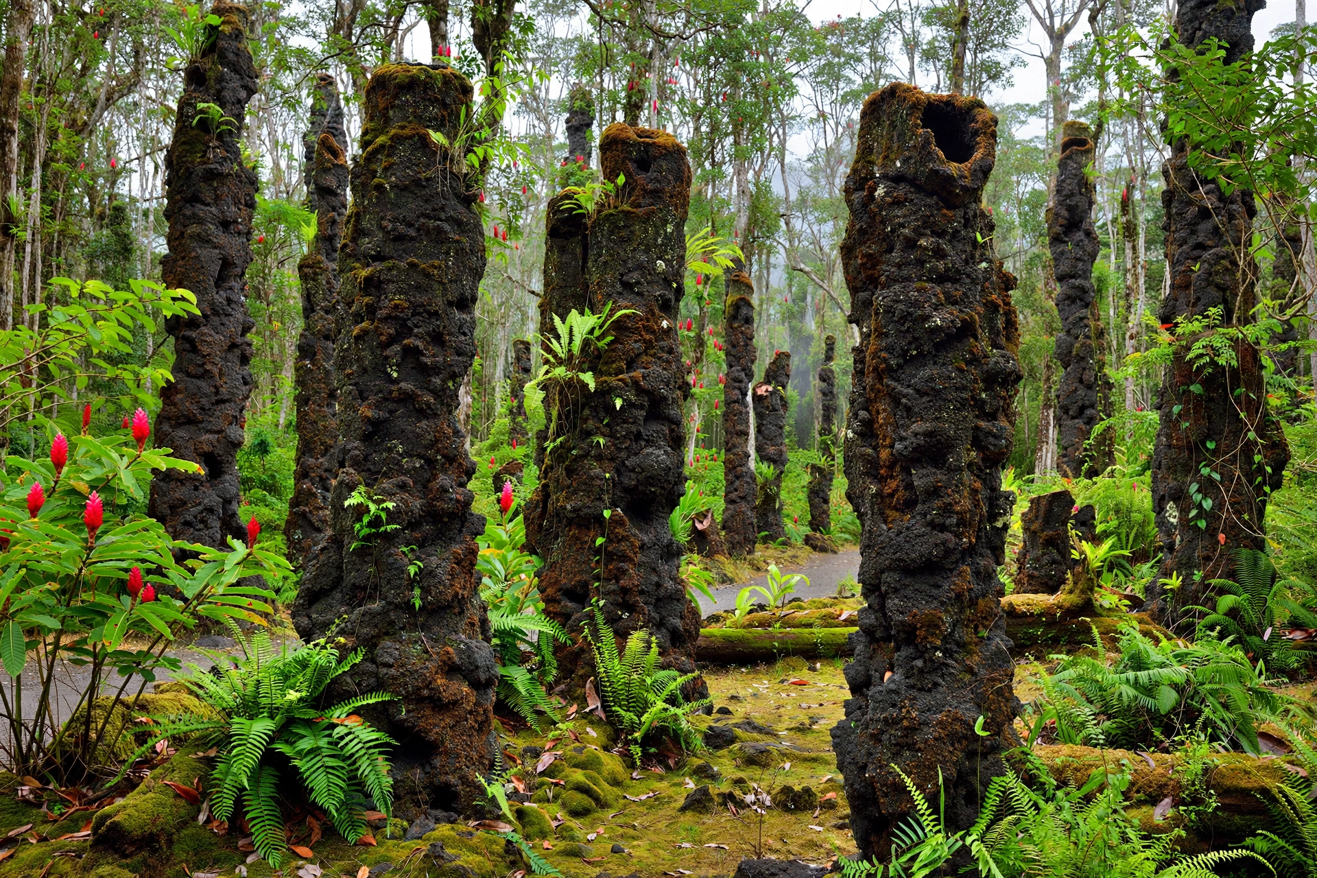
One of Puna’s signature stops, Lava Tree State Monument preserves a grove of lava tree molds: hollow stone pillars formed when a lava flow swept through a forest of ʻōhiʻa trees centuries ago. The molten rock coated the trunks, the wood burned away, and the cooled lava shells remained standing like a forest of stone. A short, easy loop trail winds through the molds beneath a canopy of regrown forest, and the whole visit takes less than an hour. It is otherworldly, accessible, and unlike anything else in the state.
Hot Springs and Warm Ponds
Puna’s geothermal activity creates warm water features found nowhere else in Hawaiʻi, but their status changes, so verify before you go. Ahalanui Park, also known as the Puna warm pond, has long been the district’s beloved ocean-fed hot pond, heated by volcanic activity to bathtub temperatures. The 2018 eruption dramatically altered the coastline around it, and access and conditions have changed since. Isaac Hale Beach Park at Pohoiki also has warm water features along its new shoreline. County parks post current status, and conditions can shift with surf and volcanic activity. Never enter water that looks or smells unusual, respect any posted closures, and understand that these are natural features, not managed spa facilities.
Pohoiki and the New Coastline
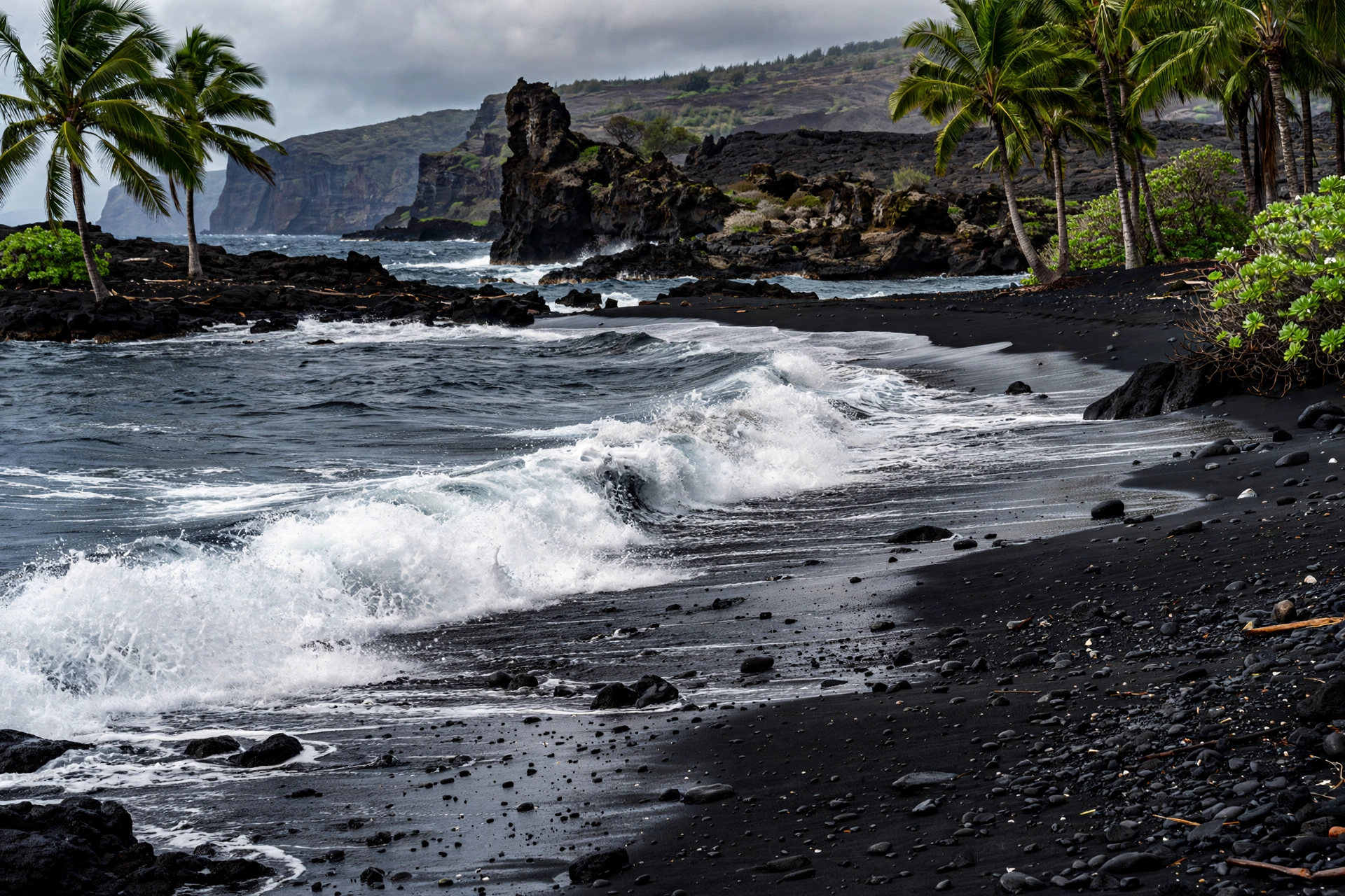
The 2018 eruption’s most visible gift is the new black sand beach at Pohoiki, built where lava met the sea at Isaac Hale Beach Park. The beach did not exist before 2018. Now it is a sweeping crescent of black sand with warm water, surf breaks, and views of the steaming new coastline. It is also a working harbor and a place of deep significance to local surfers and fishers. Go to swim, surf, or simply stand on land younger than your phone, but go with respect for the community that uses this place daily.
Kapoho Tide Pools
Before 2018, the Kapoho tide pools were among the finest snorkeling spots in the state: a network of shallow, crystal clear pools separated from the ocean by a natural lava rock barrier, full of coral and reef fish. The 2018 lava flows buried them completely. Their loss is still felt deeply by the community. This guide mentions them because older guidebooks and websites still list them, and visitors should know they no longer exist rather than driving out to look for them.
Steam Vents and Cracks
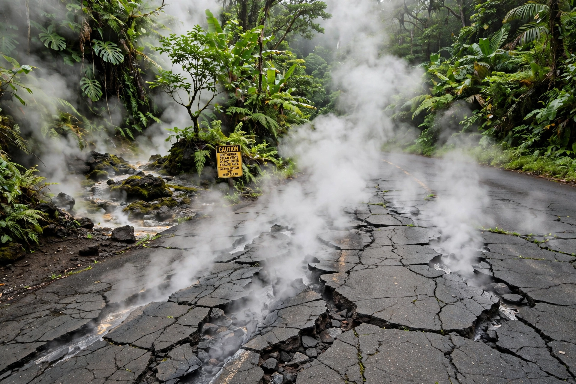
Throughout lower Puna, steam rises from cracks in the ground, particularly along the roads near the rift zone. Some roadside pullouts offer safe viewing of steaming ground, a vivid reminder that you are standing on one of the most volcanically active places on the planet. Stay on marked areas, never approach steam vents closely, and keep children and pets well back. Ground near vents can be unstable and dangerously hot.
Puna’s Beaches
Puna’s beaches are not the postcard white sand strands of Kona or Maui. They are black sand, lava rock, and wild ocean, and they demand more caution and reward more richly than the typical resort beach. There are no lifeguards at most Puna beaches. Surf and currents can be powerful, and conditions change with swell and weather. Swim only where locals swim, never turn your back on the ocean, and when in doubt, stay out.
Pohoiki / Isaac Hale Beach Park
The district’s headline beach is also its newest. The black sand beach at Pohoiki, formed by the 2018 eruption, offers swimming, surfing, and shoreline walking on land that did not exist a decade ago. The park has restrooms, parking, and a boat ramp, and it serves as a community gathering place. Warm water seeps into parts of the shoreline from geothermal activity. Respect the local surf lineup, keep the park clean, and remember you are a guest in a community space.
Keaukaha and Richardson Ocean Park
Just outside Hilo but often grouped with the Puna coast experience, Richardson Ocean Park is a black sand beach with tide pools, shade trees, and frequent sea turtle sightings. The sheltered cove is one of the more beginner friendly ocean entries on the east side, though there are no lifeguards and urchins hide in the rocky areas, so reef shoes are wise.
Honoliʻi and Other Surf Spots
Puna and the Hilo coast hold several surf breaks, including Honoliʻi Beach Park, that are central to local surf culture. These are not learn to surf beaches for visitors. If you surf, bring experience, local knowledge, and humility. If you do not surf, enjoy watching from shore.
A Word on Access
Coastline access in Puna has changed enormously since 2018, and some formerly popular spots are gone, altered, or on private land. Do not rely on old maps or pre-2018 guidebooks. Check current county park listings, respect all gates and signs, and never cross private property to reach the shore. Much of Puna’s coastline is privately owned, and access is a privilege the community extends, not a right.
Nature and Hiking
Puna’s rainforest is among the lushest in the state, fed by some of the highest rainfall totals on the island. Hiking here means mud, mosquitoes, and magnificence in roughly equal measure. Trails range from easy state park loops to rugged backcountry routes, and conditions can change fast. Bring rain gear no matter the forecast, wear shoes you do not mind destroying, and let someone know your plans on longer hikes.
Easy Walks
Lava Tree State Monument’s short loop is the district’s essential easy walk. The Pāhoa area also offers the short trails around the town’s outskirts, and the coastal walk at Isaac Hale Beach Park gives you new lava landscapes without any real hiking. For a slightly longer easy option, the trails at the nearby Hawaiʻi Volcanoes National Park, a reasonable day trip from Puna, offer everything from steam vent boardwalks to the multi-mile Kīlauea Iki loop.
MacKenzie State Recreation Area
This small coastal park preserves a grove of ironwood trees planted decades ago, with a rugged lava coastline and sea arch views. It is a quiet, uncrowded stop, good for a picnic and a short shoreline walk. The surf here is dangerous for swimming, so enjoy it from the rocks.
Malama Ki Forest Reserve and Back Roads
Puna’s interior holds forest reserves and unpaved roads that reward careful exploration. Some areas require high clearance vehicles, and many back roads cross private land. Stick to public routes, carry offline maps since cell service is unreliable, and never drive a rental car somewhere its contract forbids. Flash flooding can turn forest roads into rivers with little warning, so avoid them during heavy rain.
Wildlife
Puna’s forests hold native birds including ʻapapane and ʻamakihi, and the coastline hosts honu, Hawaiian green sea turtles, and occasional monk seals. Give seals at least 50 feet of space and turtles at least 10 feet. It is the law, and it is simple decency. Nēnē, the Hawaiian goose, are sometimes seen in the district’s higher elevations. Never feed any wild animal.
Where to Eat and Stay
Puna’s food scene punches far above its rural weight. Pāhoa’s main street holds health food stores, plate lunch spots, Thai and Filipino eateries reflecting the district’s plantation heritage, coffee shops, and bakeries. The farmers markets, particularly the weekend market in Pāhoa, are essential: tropical fruit, prepared foods, crafts, and a cross section of the community. For groceries, Pāhoa has supermarkets, but stock up before heading to the more remote corners of the district.
Lodging in Puna runs toward the independent and the alternative: vacation rentals, small bed and breakfasts, farm stays, and off-grid retreats. There are no large resorts in the district, which is precisely the point for most visitors who choose it. Book well in advance for holiday periods, read reviews carefully, and confirm exactly where a rental is located, since “Puna” covers a large area and some properties are far down rough roads. If you want resort amenities, base yourself in Hilo, about 20 to 30 minutes from upper Puna, and day trip into the district.
A practical note: Puna’s affordability relative to the rest of Hawaiʻi has made it a magnet for long term visitors and new residents. If you fall in love with the district, as many do, remember that housing pressure is a real and sensitive local issue. Visit lightly, spend locally, and leave the housing market to the people who live here.
Getting There and Around
Puna is reached by road from Hilo, about 20 to 30 minutes to Pāhoa and longer to the lower Puna coast. Most visitors fly into Hilo International Airport (ITO) on the east side or Kona International Airport (KOA) on the west side, roughly a two hour drive across the island via the Saddle Road. A rental car is effectively essential in Puna. There is no rideshare reliability in the district’s rural reaches, and the county bus, Hele-On, runs limited routes that will not get you to trailheads or beaches on a visitor’s schedule.
Driving in Puna demands attention. Rain is frequent and roads get slick. Some subdivisions have unpaved or poorly maintained roads. Lava rock will destroy a tire, so carry a spare and know how to use it. Gas up in Pāhoa or Hilo before exploring, since stations are sparse in lower Puna. And as always on the Big Island, never leave valuables visible in a parked car at trailheads or beaches.
Frequently Asked Questions
Where is Puna in Hawaiʻi?
Puna is a district on the eastern side of the Island of Hawaiʻi, the Big Island, stretching from the slopes of Kīlauea volcano down to the Puna coastline. Its main town is Pāhoa, about 20 to 30 minutes south of Hilo by car.
What happened in Puna in 2018?
Kīlauea’s East Rift Zone erupted in the Leilani Estates subdivision beginning May 3, 2018. Over three months, lava flows destroyed more than 700 homes, covered roads and farmland, filled Kapoho Bay, and created new land including the black sand beach at Pohoiki. Thousands of residents were displaced.
Is Puna safe to visit?
Yes, with normal volcanic landscape precautions. Check the USGS Hawaiian Volcano Observatory and Hawaiʻi County sources for current conditions, respect all closures and private property, stay on marked paths near steam vents and new lava, and never approach active volcanic features. The 2018 eruption zone is a residential recovery area, not a tourist attraction.
Can you still see lava in Puna?
That depends entirely on Kīlauea’s current activity, which changes. Sometimes lava is visible within Hawaiʻi Volcanoes National Park; sometimes there is no surface activity anywhere. Check the USGS Hawaiian Volcano Observatory for current eruption status before your trip, and do not expect guaranteed lava viewing.
What are the best beaches in Puna?
Pohoiki at Isaac Hale Beach Park, the new black sand beach formed in 2018, is the district’s standout. Richardson Ocean Park near Hilo offers calmer swimming and turtle sightings. Most Puna beaches have no lifeguards and demand ocean caution.
Are the Puna hot springs still open?
Status changes. Ahalanui Park’s warm pond and other geothermal features were affected by the 2018 eruption and coastal changes. Check Hawaiʻi County park listings for current access before going, and never enter water that looks or smells unusual.
How much time do you need in Puna?
A full day covers Pāhoa, Lava Tree State Monument, and Pohoiki. Two days lets you add the farmers market, coastal parks, and a slower pace. Many visitors base in Hilo and day trip; others stay in Puna vacation rentals for a deeper experience.
Do you need a rental car in Puna?
Effectively yes. Puna is rural and spread out, public transit is limited, and rideshares are unreliable in the district’s remoter areas. A rental car gives you access to beaches, trailheads, and towns on your own schedule.
Related Guides
- Where Is the Big Island in Hawaiʻi: position, regions, and airports for the whole island
- Hawaiʻi Volcanoes: Kīlauea, Mauna Loa, and visiting Hawaiʻi Volcanoes National Park
- Big Island Weather: seasons, microclimates, and what to pack
- Hawaiʻi Beaches: the statewide beach guide, from white sand to black sand
- Hāwī, Hawaiʻi: North Kohala’s historic plantation town
- Best Time to Visit Hawaiʻi: month by month planning guidance
- Hawaiʻi Map: the islands, districts, and driving orientation
A Final Note
Puna is Hawaiʻi at its most alive: a district where the ground is still being made, where rainforest and fresh lava sit side by side, and where a community rebuilt itself after one of the most destructive eruptions in the state’s modern history. It rewards visitors who come with curiosity, humility, and respect for both the land and the people who call it home. Drive its back roads slowly, swim where locals swim, buy your lunch in Pāhoa, and take a moment at the edge of the new coastline to consider what it means to stand on the newest land in the United States. Puna does not perform for visitors. It simply is, and that is exactly why it matters.