
Where Is Oʻahu Located in Hawaiʻi
On This Page
Quick Answer: Where Is Oʻahu?
Oʻahu sits in the North Pacific Ocean, about 2,400 miles southwest of California and roughly 2,000 miles from the nearest landmass in any direction, which makes Hawaiʻi the most isolated major island chain on Earth. Within the Hawaiian archipelago, Oʻahu is the third largest island by area and the most populated by far. It sits at the northwestern end of the main inhabited Hawaiian Islands, between Kauaʻi to the northwest and Molokaʻi to the southeast.
If you picture the Hawaiian chain as a long diagonal line running from southeast to northwest, Oʻahu occupies the middle of the inhabited group: Hawaiʻi Island (the Big Island) and Maui anchor the southeast end, while Oʻahu sits roughly 72 miles northwest of Maui’s western shore, with the islands of Molokaʻi and Lānaʻi filling the channel between them. Kauaʻi and Niʻihau lie beyond Oʻahu to the northwest.
Oʻahu’s coordinates center on approximately 21.5° N latitude and 157.9° W longitude. The island covers about 597 square miles, measures roughly 44 miles long and 30 miles wide at its broadest point, and is home to roughly one million residents, about 70 percent of the state’s entire population. Honolulu, the state capital and Hawaiʻi’s only major city, occupies the island’s southeastern shore. Most visitors arrive at Daniel K. Inouye International Airport (HNL), which sits on Oʻahu’s south shore just west of downtown Honolulu and serves as the state’s main aviation gateway.

Oʻahu in the Island Chain
The Hawaiian archipelago stretches more than 1,500 miles across the North Pacific, but the eight main inhabited islands cluster in the southeastern 400 miles of that line. Oʻahu is the third of these eight when traveling from southeast to northwest, after the Big Island and Maui County’s islands. This position is no accident. The islands formed one by one as the Pacific tectonic plate drifted northwest over a stationary volcanic hotspot, so the chain reads like a timeline: the youngest island (the Big Island, still growing) sits at the southeast end, and the oldest main islands (Kauaʻi and Niʻihau, around five million years old) sit at the northwest end. Oʻahu, at roughly three to four million years old, falls squarely in the middle of that story, and its deeply eroded mountain ranges show it. The jagged Koʻolau cliffs on the windward side are the eroded remains of a massive shield volcano whose eastern half collapsed into the sea in an ancient landslide.
Neighbors in Every Direction
To the northwest lies Kauaʻi, about 72 miles across the Kauaʻi Channel from Oʻahu’s northwestern tip at Kaʻena Point. On exceptionally clear days, Kauaʻi’s silhouette can be glimpsed from Oʻahu’s highest ridges, though the curvature of the Earth and trade wind haze usually keep it hidden. The channel between them is deep open ocean, and no ferry connects the two islands. All inter-island travel between Oʻahu and Kauaʻi happens by air.
To the southeast, the island of Molokaʻi sits about 26 miles across the Kaiwi Channel from Oʻahu’s southeastern shore. Molokaʻi is plainly visible from Oʻahu’s windward coast on clear days, its long flat profile rising across the channel. Beyond Molokaʻi lie Lānaʻi and Maui, and on the clearest mornings the summit of Haleakalā on Maui can be seen from Oʻahu’s eastern ridges, more than 100 miles away.
Oʻahu has no land borders, of course, and its nearest international neighbor is thousands of miles away in every direction. This isolation shaped everything about the island, from the unique species that evolved here to the voyaging culture that first settled it.
Size and Ranking
Oʻahu ranks third in area among the Hawaiian Islands, behind the Big Island (about 4,028 square miles) and Maui (about 727 square miles), and just ahead of Kauaʻi (about 552 square miles). But area tells only a fraction of the story. Oʻahu’s population of roughly one million dwarfs every other island: the Big Island holds about 200,000 residents, Maui about 165,000, and Kauaʻi about 73,000. This concentration makes Oʻahu the political, economic, and cultural center of the state, and it means the island’s infrastructure, from its international airport to its rail system, operates at a scale found nowhere else in Hawaiʻi.
Coordinates and Geography
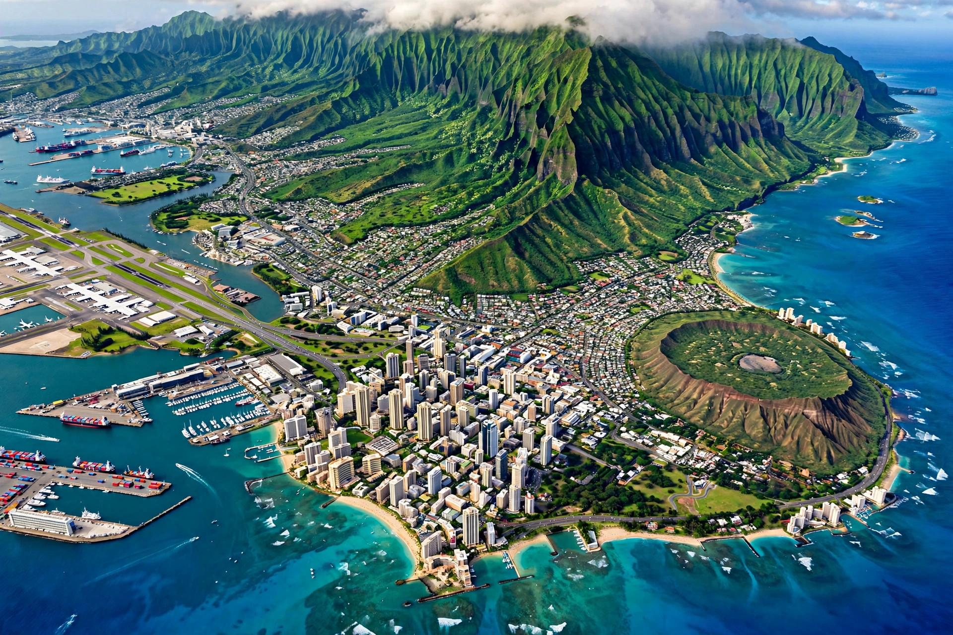
Oʻahu spans roughly 21.3° to 21.7° N latitude and 157.7° to 158.3° W longitude. Downtown Honolulu sits near 21.31° N, 157.86° W. These coordinates place the island firmly in the tropics but north of the equator by enough margin that Hawaiʻi experiences subtle seasons: a warmer, drier summer (roughly April through October) and a cooler, wetter winter (roughly November through March). Daytime highs in Honolulu average in the mid 80s Fahrenheit in summer and the upper 70s in winter, a narrow band that surprises many first-time visitors expecting equatorial heat.
Geographically, Oʻahu is defined by two parallel volcanic mountain ranges. The Koʻolau Range runs along the island’s eastern (windward) side, a wall of fluted green cliffs that catches the northeast trade winds and wrings out their moisture. The Waiʻanae Range runs along the western (leeward) side, older and drier, with Mt. Kaʻala (4,025 feet) as the island’s highest point. Between them lies the central Oʻahu plain, a broad agricultural plateau where pineapple and sugar once dominated and where the towns of Wahiawā and Mililani now sit.
The trade winds shape Oʻahu’s geography into two distinct faces. The windward (eastern) side, from Waimānalo through Kāneʻohe to the North Shore, is lush, rainy, and green. The leeward (western and southern) side, including Honolulu, Waikīkī, Kapolei, and the Waiʻanae Coast, sits in the rain shadow and is noticeably drier and sunnier. This is why Honolulu, the population center, grew where it did: a sunny, sheltered south shore with a natural harbor.
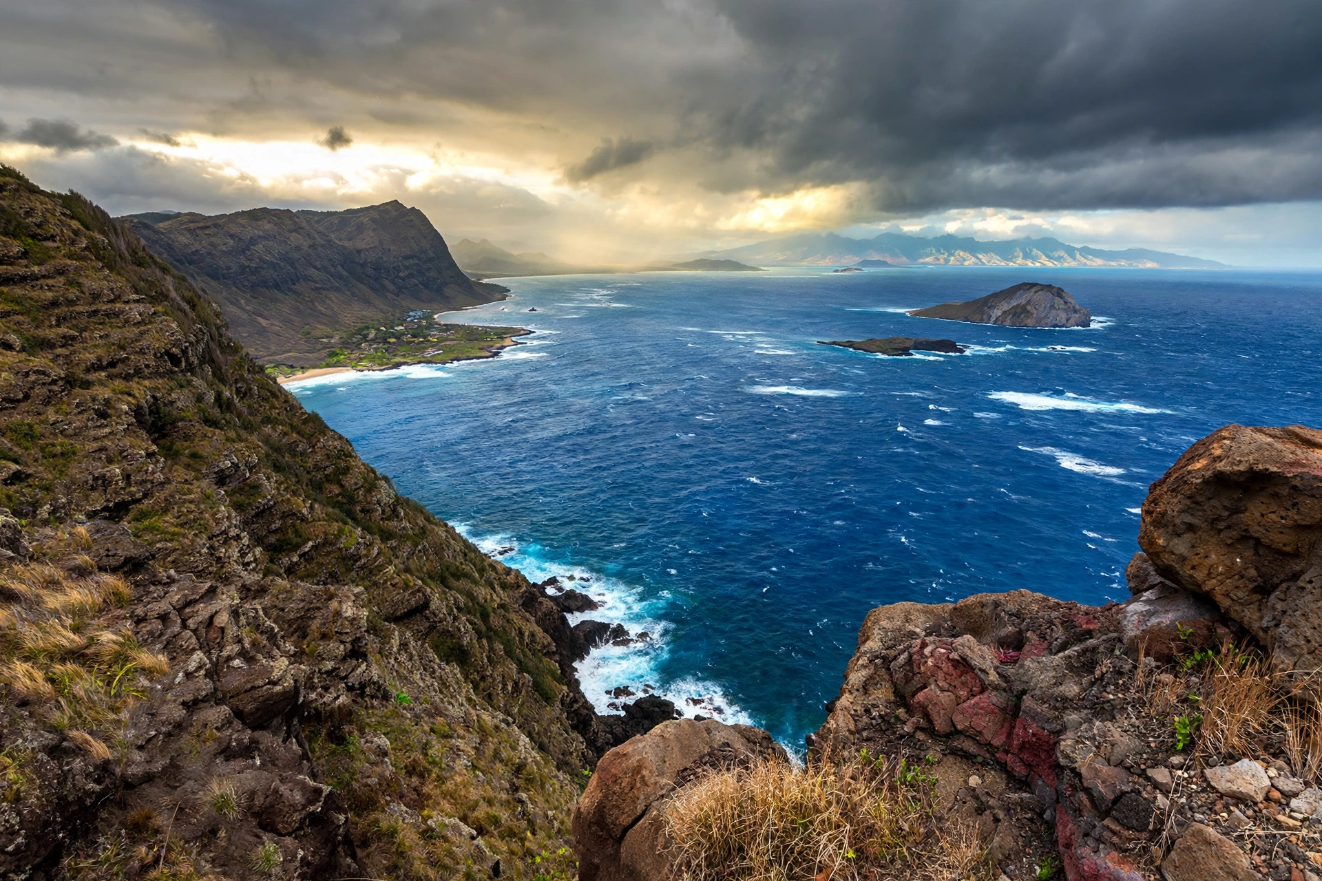
At the island’s extremes, the geography tells the story of its age. Kaʻena Point, the westernmost tip of Oʻahu, is a windswept natural area reserve where the Waiʻanae Range meets the sea in rugged cliffs and tide pools; it is reachable only on foot and feels far removed from the city. At the opposite corner, Makapuʻu Point on the southeastern tip holds a historic lighthouse and some of the island’s best whale watching lookouts in winter, with views across to Molokaʻi and, on the clearest days, Maui and Lānaʻi beyond. Between these points, the island’s coastline alternates between sandy beaches, rocky headlands, and the calm reef-protected lagoons of the leeward side.
Oʻahu’s reefs deserve mention in any geographic account. Much of the island’s shoreline is fringed by coral reefs that calm the surf and create the turquoise lagoons visitors associate with Hawaiʻi. The south shore’s famous breaks, from Waikīkī to Ala Moana, roll over reef shelves, while the windward side’s barrier reefs enclose Kāneʻohe Bay, the only true barrier reef system in the main Hawaiian Islands. These reefs are living geography, and they explain why Oʻahu’s beaches look and behave so differently from one coast to the next.
Visible Neighbors
From Oʻahu’s shores, the neighboring islands are part of the daily scenery. Molokaʻi’s long profile dominates the view from the windward coast and from eastern lookouts like Makapuʻu Point. Lānaʻi appears as a low silhouette beyond Molokaʻi on clear days. From the North Shore and Kaʻena Point, Kauaʻi occasionally emerges on the horizon at dawn when the air is clearest. These sightlines remind visitors that the Hawaiian Islands, while separated by deep channels, form a single visible family from Oʻahu’s high points.
Getting to Oʻahu
Nearly every visitor to Hawaiʻi arrives through Oʻahu first. Daniel K. Inouye International Airport (HNL) in Honolulu is the state’s primary aviation gateway, handling the vast majority of mainland and international flights. The airport sits on the island’s south shore, about 10 miles west of Waikīkī and immediately west of downtown Honolulu and Pearl Harbor. Most travelers bound for other islands connect through HNL to inter-island flights, which is one reason Oʻahu functions as the hub of the entire state’s transportation network.
Inter-island carriers connect HNL with every other major island’s airport: Kahului (OGG) on Maui, Līhuʻe (LIH) on Kauaʻi, Kona (KOA) and Hilo (ITO) on the Big Island, Hoʻolehua (MKK) on Molokaʻi, and Lānaʻi City (LNY) on Lānaʻi. Flights between Oʻahu and Maui or Kauaʻi take roughly 30 to 45 minutes. There is no ferry service between Oʻahu and any other island for passengers or vehicles; all inter-island travel to and from Oʻahu happens by air. The island’s harbors serve cruise ships, cargo, and military vessels, but no scheduled passenger ferry connects Oʻahu to its neighbors.
Once on Oʻahu, visitors find the state’s most developed ground transportation. TheBus, Honolulu’s public transit system, covers the island with extensive routes. The Skyline rail system connects East Kapolei through the airport toward downtown Honolulu. Rental cars are widely available at HNL and throughout Waikīkī, and the island’s highway system (H-1, H-2, H-3, and the Pali Highway) links every region. For a full breakdown, see our Oʻahu transportation guide and the statewide Hawaiʻi transportation guide.

Regions of Oʻahu
Oʻahu’s compact size makes it possible to experience several distinct regions in a single day, but each has its own character shaped by the island’s geography.
Honolulu and the South Shore
The south shore holds Honolulu, the state capital, along with Waikīkī, Pearl Harbor, and the airport. This is the urban heart of Hawaiʻi: high-rises, the state capitol building, ʻIolani Palace (the only royal palace on U.S. soil), museums, and the densest dining and shopping in the state. Waikīkī, technically a Honolulu neighborhood rather than a separate town, is the center of the visitor industry, with its famous beach framed by Diamond Head crater to the east. The south shore’s leeward position keeps it sunny most of the year.
Windward Coast
Across the Koʻolau Range lies the windward side: Kāneʻohe, Kailua, and Waimānalo. This is Oʻahu’s lush face, with the island’s most dramatic mountain scenery, offshore islets like the Mokulua Islands and Chinaman’s Hat (Mokoliʻi), and beaches like Lanikai and Kailua that regularly rank among the world’s best. The windward towns feel suburban and residential, a contrast to Honolulu’s density, and the drive over the Pali Highway or through the H-3 tunnels is itself one of the island’s great scenic transitions.
North Shore
Oʻahu’s North Shore, centered on the historic plantation town of Haleʻiwa, is legendary in surf culture. In winter, swells generated by North Pacific storms arrive at breaks like Pipeline, Waimea Bay, and Sunset Beach, drawing the world’s best surfers and the Vans Triple Crown competitions. In summer, the same ocean turns calm and swimmable. The North Shore’s country atmosphere, with its shrimp trucks, surf shops, and small-town pace, feels a world away from Honolulu despite being less than an hour’s drive.
Leeward and Waiʻanae Coast
West of Honolulu, the leeward side runs through Kapolei (Oʻahu’s fast-growing “second city”) to the Waiʻanae Coast. This is the driest part of the island, with sunny beaches like Ko Olina’s lagoons and Yokohama Bay. The Waiʻanae Range rises steeply behind the coast, and the far western tip at Kaʻena Point is a protected natural area reserve reached only on foot.
Central Oʻahu
The central plateau between the two mountain ranges holds former plantation lands, the towns of Wahiawā and Mililani, and working agricultural operations including the Dole Plantation. This region is the island’s breadbasket and a reminder of the sugar and pineapple economy that shaped modern Oʻahu before tourism took over.
What makes Oʻahu unusual among the Hawaiian Islands is how much of it is accessible in a single day. The island’s highway system crosses from Honolulu to the North Shore in under an hour, and the H-3 interstate cuts straight through the Koʻolau Range in a series of tunnels and viaducts that rank among the most scenic freeway drives in the United States. This compactness means a visitor can watch sunrise from Lanikai Beach, have lunch in Haleʻiwa, and be back in Waikīkī for dinner, experiencing three distinct climates and landscapes in between. Few places on Earth pack that much geographic variety into 597 square miles.
How Oʻahu Compares to Its Neighbors
Visitors often ask how Oʻahu differs from the other islands beyond just size. The Big Island is vast and volcanic, with active lava landscapes, snow-capped summits, and long driving distances between sights. Maui balances resort development with upcountry farms and the massive Haleakalā crater. Kauaʻi is the garden island, older, wetter, and more rugged, with the Nā Pali Coast and Waimea Canyon. Molokaʻi and Lānaʻi are small and quiet, with limited infrastructure. Oʻahu stands apart as the urban island, the only one with a true city, a rail system, and the full apparatus of a state capital. Its location in the middle of the chain makes it the connective tissue: every inter-island itinerary passes through Honolulu, and the island’s diversity, from world-class surf to royal palaces to quiet windward valleys, gives it a breadth the smaller islands cannot match.

Why Oʻahu’s Location Matters
Oʻahu’s position in the middle of the inhabited chain made it the natural center of gravity for the Hawaiian Kingdom, the territorial government, and the modern state. Honolulu’s sheltered harbor on the sunny south shore offered the best anchorage in the islands, and by the mid 19th century it had become the kingdom’s capital and busiest port. ʻIolani Palace, built in Honolulu in the 1880s, still stands as a monument to that era. When Hawaiʻi became a U.S. territory and later the 50th state in 1959, Honolulu remained the capital, and the concentration of government, business, and military on Oʻahu only deepened.
The island’s central location also made it strategically vital. Pearl Harbor, on Oʻahu’s south shore just west of Honolulu, became the headquarters of the U.S. Pacific Fleet, and the December 7, 1941 attack on the harbor thrust the United States into World War II. Today the Pearl Harbor National Memorial draws visitors from around the world, and the island still hosts major military installations across all services. Oʻahu’s position, roughly equidistant from the U.S. West Coast and East Asia, keeps it relevant to Pacific strategy more than eighty years later.
For travelers, Oʻahu’s location makes it the logical first stop. Its central position means the shortest inter-island flights in every direction, its airport offers the most flight options and usually the best fares, and its sheer density of accommodations, restaurants, and activities suits first-time visitors who want variety without island hopping. Many travelers split their trips between Oʻahu and one neighbor island, using Honolulu as the hub. Others spend their entire visit on Oʻahu alone and find its regions diverse enough to fill two weeks.
Oʻahu’s location also shapes its weather advantage. The island’s south shore sits in the lee of the Koʻolau Range, which is why Waikīkī and Honolulu enjoy sunshine while the windward side gets rain. And because Oʻahu sits in the middle of the chain, it avoids the Big Island’s volcanic vog more often than not, though Kona winds can occasionally carry haze northwest across the channels.
There is a deeper history embedded in Oʻahu’s position. Long before Western contact, the island’s central location made it a crossroads for inter-island voyaging. Hawaiian navigators traveling between Kauaʻi and Maui passed Oʻahu’s shores, and the island’s chiefs played pivotal roles in the archipelago’s politics. Kamehameha I, who would unite the islands, fought decisive battles on Oʻahu, including the Battle of Nuʻuanu in 1795, where his forces drove rival warriors over the Pali cliffs. The island’s location made it the prize worth winning, and it has remained the seat of power ever since.
In the modern era, Oʻahu’s mid-Pacific coordinates give it a significance that extends beyond tourism. The island sits roughly midway between North America and Asia, a geographic fact that underpins its military importance and its role as a cultural bridge. Honolulu hosts the East-West Center, founded to promote understanding between the United States and the Asia-Pacific region, and the city’s population reflects centuries of migration from China, Japan, Korea, the Philippines, Portugal, and beyond. Oʻahu’s location at the crossroads of the Pacific made it a meeting place long before airplanes existed, and the island’s food, festivals, and neighborhoods still show it.

Frequently Asked Questions
Where exactly is Oʻahu located?
Oʻahu is in the North Pacific Ocean at roughly 21.5° N, 157.9° W, about 2,400 miles southwest of California. Within the Hawaiian chain, it sits between Kauaʻi to the northwest and Molokaʻi to the southeast, at the northwestern end of the main inhabited islands.
Is Oʻahu the biggest Hawaiian island?
No. Oʻahu is the third largest by area (about 597 square miles), behind the Big Island and Maui. But it is by far the most populated, with roughly one million residents, about 70 percent of the state’s population.
Which islands are closest to Oʻahu?
Molokaʻi is the closest, about 26 miles southeast across the Kaiwi Channel and visible from Oʻahu’s windward coast. Kauaʻi lies about 72 miles northwest across the Kauaʻi Channel. Maui and Lānaʻi sit beyond Molokaʻi to the southeast.
Can you see other islands from Oʻahu?
Yes. Molokaʻi is clearly visible from Oʻahu’s east and southeast shores on most days. Lānaʻi appears as a distant silhouette on clear days, and Kauaʻi can occasionally be glimpsed from Oʻahu’s northwestern ridges at dawn when the air is exceptionally clear.
What airport do you fly into for Oʻahu?
Daniel K. Inouye International Airport (HNL) in Honolulu, on Oʻahu’s south shore. It is Hawaiʻi’s main gateway, handling most mainland and international flights plus all inter-island connections.
Is Honolulu on Oʻahu?
Yes. Honolulu occupies Oʻahu’s southeastern shore and is both the state capital and Hawaiʻi’s largest city. Waikīkī is a neighborhood within Honolulu, not a separate town.
How far is Oʻahu from Maui?
The islands are separated by the islands of Molokaʻi and Lānaʻi in between. By air, Honolulu to Kahului (Maui) is a roughly 30 to 45 minute flight. There is no ferry between Oʻahu and Maui; all inter-island travel from Oʻahu is by air.
Why do most visitors start their trip on Oʻahu?
Oʻahu’s central location, the state’s main airport, the most flight options, and the greatest density of hotels, restaurants, and activities make it the natural hub. Its position also means the shortest connecting flights to every other island.
Related Guides
- Oʻahu Travel Guide: the complete island overview
- Oʻahu Towns: Honolulu, Haleʻiwa, Kailua, and more
- Oʻahu Transportation: getting around the island
- Hawaiʻi Map: the full island chain at a glance
- Where Is the Big Island in Hawaiʻi?: Oʻahu’s southeastern neighbor
- Hawaiʻi Transportation: inter-island flights and ferries
- Best Time to Visit Hawaiʻi: planning your trip timing
A Final Note
Oʻahu’s location tells the story of Hawaiʻi in miniature. Its middle position in the island chain made it the meeting point of kingdom politics, plantation labor, military strategy, and modern tourism. The island you see today, with a million residents and visitors from every continent, grew from the same geographic logic that first drew Polynesian voyagers, then whalers, then sugar barons to its sheltered south shore. Understanding where Oʻahu sits is the first step to understanding how the islands fit together, and it makes every view across the Kaiwi Channel toward Molokaʻi feel like a connection rather than a distance.