
Oʻahu Map
On This Page

Oʻahu at a Glance
Oʻahu is the island most visitors meet first, and for good reason. It holds roughly two thirds of the state’s population, the capital city of Honolulu, the international airport, the busiest harbor, the largest university, and the densest concentration of historic sites in Hawaiʻi. The nickname is the Gathering Place, and the map explains why: nearly every road worth driving on the island eventually connects back to Honolulu, yet within an hour in any direction the scenery changes completely, from city towers to pineapple fields, from turquoise bays to the pounding surf of the North Shore.
Geographically, Oʻahu is the third largest island in the chain at roughly 597 square miles, about 44 miles long and 30 miles wide at its broadest points. It is a volcanic island built from two shield volcanoes that are now extinct. The Waiʻanae Range runs along the western side, with Mt. Kaʻala, the island’s highest peak at 4,025 feet, standing at its northern end. The Koʻolau Range forms the dramatic green wall along the eastern side, rising almost vertically behind Honolulu and the Windward towns. Between the two ranges lies the central plateau, historically the home of pineapple and sugar plantations, now a mix of farmland, military installations, and suburbs. This mountain-and-valley anatomy is the key to reading any Oʻahu map: the ranges dictate where the highways go, where the rain falls, and where the beaches face.
The name Oʻahu carries its own story. According to Hawaiian tradition, it means “the gathering place,” a fitting description for an island that has drawn people together for centuries. It was here that Kamehameha I secured control of the islands after the Battle of Nuʻuanu in 1795, and it was here that Honolulu grew from a modest harbor town into the political and commercial center of the Hawaiian Kingdom, the Republic, and then the state. ʻIolani Palace, the only official royal residence in the United States, still stands in downtown Honolulu, a reminder that Oʻahu has been the seat of government for the entire archipelago for more than two centuries.
Population is what separates Oʻahu most sharply from its neighbors. About one million people live on the island, compared with roughly 200,000 on the Big Island, 165,000 on Maui, and 73,000 on Kauaʻi. For travelers, that means Oʻahu offers the deepest bench of restaurants, shops, museums, and services, along with the only true freeway system in the islands and the most extensive public transit. It also means traffic. The morning and afternoon rush hours on the H-1 freeway are real, and smart trip planning on Oʻahu means thinking about when you drive, not just where.
Climate follows the familiar Hawaiian pattern, with a twist that the mountains make visible. The Windward (east) side, facing the trade winds, is lush, green, and rainy. The Leeward (west) side sits in the rain shadow and is noticeably drier and hotter. Honolulu and Waikīkī, on the south shore, enjoy some of the most reliably sunny weather in the islands, with daytime highs usually in the 80s Fahrenheit in summer and the high 70s in winter. Rain is most common from November through March, and brief showers are part of daily life even in dry areas. Ocean conditions flip by season: the North Shore swells to world famous surf in winter while the South Shore goes calm, and in summer the pattern reverses.
This page is organized as a map first and a guide second. Read it to understand where things are in relation to each other, which is the single most useful skill for planning days on Oʻahu. For deep detail on beaches, trails, and snorkeling, the dedicated guides linked at the end go further than a map page should.
Map: Oʻahu’s Regions and Districts
Oʻahu divides naturally into five regions, and once you learn them you can place almost any attraction on the map in seconds. The boundaries follow the mountain ranges and the highway system, so they are geographic realities rather than marketing labels.
Honolulu and the Southeast
Honolulu occupies the southeastern corner of the island, spreading from Pearl Harbor east to Diamond Head and beyond to Hawaiʻi Kai. This is the urban heart: downtown Honolulu with its government buildings and historic district, the Waikīkī resort zone along two miles of beach, the neighborhoods of Kaimukī and Kapahulu inland, and the residential ridges of Mānoa and Pālolo climbing toward the Koʻolau Range. Diamond Head, known in Hawaiian as Lēʻahi, marks the eastern edge of Waikīkī and is visible from almost everywhere in the city. Most visitors spend at least their first and last nights here, and Honolulu is the natural base for Pearl Harbor, the museums, and the south shore beaches.
The Windward Coast
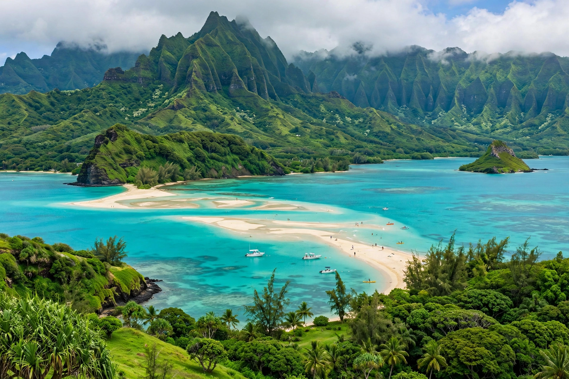
The Windward Coast runs along the island’s eastern side beneath the Koʻolau cliffs, from Kāneʻohe in the north to Waimānalo in the south. This is the lush, green Oʻahu: neighborhoods tucked against near vertical emerald mountains, offshore islets like the Mokulua Islands off Lanikai, and the sweeping curve of Kāneʻohe Bay, the largest sheltered body of water in the main Hawaiian Islands. The main towns are Kāneʻohe, a commercial and residential center, and Kailua, famous for its twin beaches. Waimānalo stretches south toward Makapuʻu Point, where the Windward Coast ends and the Southeast region begins at the island’s easternmost tip. Rainfall is higher here than anywhere else on Oʻahu except the mountain summits, which is exactly why it looks the way it does.

The North Shore
The North Shore is a country district rather than a city, a roughly 17 mile stretch of coastline from Kaʻena Point in the west to Kahuku in the east. Its anchor is Haleʻiwa, a historic plantation town that now serves as the North Shore’s commercial and dining hub. The coastline itself is legendary in winter, when swells generated by North Pacific storms produce some of the largest rideable waves on earth at spots like Waimea Bay, Sunset Beach, and the Banzai Pipeline. In summer, those same beaches go glassy calm and become some of the island’s best swimming and snorkeling spots, which surprises many first time visitors. The North Shore is largely rural: shrimp trucks, roadside stands, small galleries, and the long beaches are the character of the place.
The Leeward Coast
The Leeward Coast, also called the West Side, runs from Kaʻena Point south to Barber’s Point and ʻEwa. Sitting in the rain shadow of the Waiʻanae Range, it is the driest and sunniest part of the island, and also the least visited by tourists. The main communities are Waiʻanae, Nānākuli, and Mākaha along the coast, with the master planned resort community of Ko Olina, known for its lagoons, sitting farther south near Kapolei. The second city of Kapolei is growing fast as a commercial center for the western half of the island. Travelers come to the Leeward Coast for sunny beaches, dolphin and whale watching departures from Waiʻanae, and a side of the island that feels far removed from Waikīkī.
Central Oʻahu
Central Oʻahu is the broad plateau between the two mountain ranges, running from Pearl City and Mililani in the south to Wahiawā in the north. This was plantation country for most of the 20th century, and pineapple and sugar shaped everything about it. Today the landscape is a patchwork of former plantation towns, military installations including Schofield Barracks and Wheeler Army Airfield, suburban communities, and working farmland. Wahiawā, the northern anchor of the plateau, is home to the Dole Plantation visitor stop. Central Oʻahu matters to visitors mostly as the corridor they drive through: the H-2 freeway runs straight up the middle of the plateau, connecting Honolulu to the North Shore in about 45 minutes when traffic cooperates.
How the Regions Connect
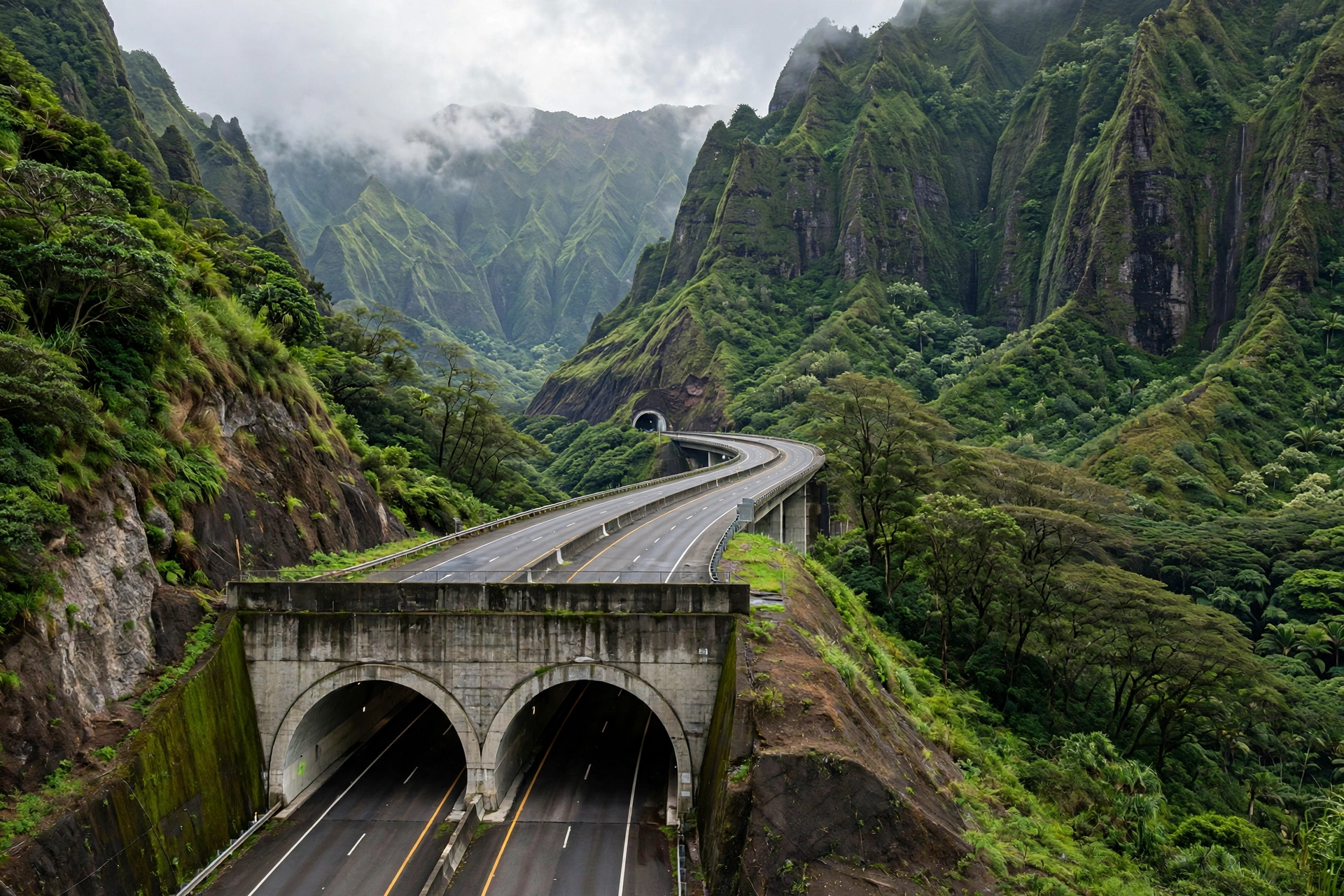
The five regions meet at natural chokepoints that every Oʻahu driver learns. The H-3 freeway tunnels through the Koʻolau Range connecting Honolulu to Kāneʻohe on the Windward side. The Pali Highway crosses the range farther south at the Nuʻuanu Pali lookout, joining Honolulu to Kailua. Kamehameha Highway wraps the island’s perimeter, running from Kāneʻohe up the Windward Coast, across the North Shore, and down the Leeward Coast to join the freeway system at Pearl City. Farrington Highway handles the far Leeward Coast to Kaʻena Point, where the road simply ends and the wilderness begins. Understanding these connections is what turns an Oʻahu map from decoration into a planning tool.
Key Towns and Areas
Oʻahu’s towns each have a distinct personality, and choosing where to stay and how to spend your days usually comes down to understanding a handful of them.
Honolulu
Honolulu is the capital of Hawaiʻi and by far the largest city in the state, home to roughly a third of Oʻahu’s population within the city limits and far more in the surrounding metro area. Downtown Honolulu holds the historic core: ʻIolani Palace, the State Capitol, Kawaiahaʻo Church, and the Hawaiʻi State Art Museum sit within a few walkable blocks. The Chinatown district, just west of downtown, is one of the oldest in the United States and is now a center for food and arts. Honolulu is also where the island’s major museums live, including the Bishop Museum, the premier institution for Hawaiian and Pacific history, and the Honolulu Museum of Art. For travelers, downtown Honolulu works best as a day trip destination from a Waikīkī base rather than as a place to stay.
Waikīkī
Waikīkī is the resort district within Honolulu, a compact neighborhood roughly two miles long and a half mile wide, bounded by the Ala Wai Canal on the mauka (mountain) side and the beach on the makai (ocean) side. Kalākaua Avenue runs along the beach, lined with hotels, shops, and restaurants, while Kūhiō Avenue one block inland is the local commercial strip. The beach itself is a series of connected sections: Kūhiō Beach and Queen’s Surf near the center, the Royal Hawaiian stretch, and the quieter Fort DeRussy area at the western end. Diamond Head anchors the eastern end of the neighborhood. Waikīkī is where the majority of Oʻahu’s hotel rooms are concentrated, and its walkability is unmatched anywhere else in the islands. A dedicated walking guide covers its routes in detail at /waikiki-walking-map/.
Kāneʻohe
Kāneʻohe is the commercial center of the Windward side, a town of about 35,000 people set against the Koʻolau cliffs at the head of Kāneʻohe Bay. It is primarily a residential and shopping hub for windward residents rather than a tourist destination, but it matters to visitors as the gateway to several major sights: the Hoʻomaluhia Botanical Garden, the Byodo-In Temple in the Valley of the Temples, and the sandbar tours that depart into Kāneʻohe Bay. The town sits at the Windward end of the H-3 freeway and the Likelike Highway, making it about 20 minutes from Honolulu in light traffic.
Kailua
Kailua, just south of Kāneʻohe on the Windward Coast, is Oʻahu’s most popular beach town. Kailua Beach Park stretches for two and a half miles of fine white sand, and adjacent Lanikai Beach is regularly ranked among the most beautiful beaches in the world, with its offshore Mokulua islets and calm turquoise water. The town itself has a walkable center with restaurants, shops, and a famous farmers market. Kailua works well as an alternative base to Waikīkī for travelers who want a quieter, more residential feel with world class beaches on foot. The drive from Honolulu takes about 20 to 25 minutes over the Pali Highway or via the H-3.
Haleʻiwa
Haleʻiwa is the heart of the North Shore, a former plantation town of about 4,000 people that now functions as the area’s main street for dining, shopping, and surf culture. The town is listed on the National Register of Historic Places, and its plantation era storefronts house shave ice shops, galleries, and boutiques. Haleʻiwa sits at the mouth of the Anahulu River near Haleʻiwa Aliʻi Beach Park, and it is the natural stop for anyone driving the North Shore, whether for winter surf watching or summer swimming. From Waikīkī, the drive via the H-2 and Kamehameha Highway takes about 45 minutes to an hour.
Other Notable Areas
Several other places round out the map. Hawaiʻi Kai, at the southeastern tip beyond Diamond Head, is a residential marina community and the launching point for Hanauma Bay, Koko Head, and Makapuʻu. Kapolei, on the Leeward side, is the island’s designated second city, with growing shopping, dining, and the Ko Olina resort lagoons nearby. Wahiawā, in Central Oʻahu, is the gateway to the Dole Plantation and the trailheads of the central plateau. Lāʻie, on the northeastern coast, is home to the Polynesian Cultural Center and Brigham Young University’s Hawaiʻi campus. Each of these sits on the main highway loops, so none requires going out of your way.
Driving Routes and Distances
Oʻahu has the only interstate highway system in Hawaiʻi, and learning its handful of roads is the fastest way to become confident on the island. Traffic is the main variable: a drive that takes 20 minutes at midday can take an hour at rush hour, so the times below assume light to moderate traffic.
The Freeways: H-1, H-2, and H-3
The H-1 freeway is the island’s main artery, running east to west from Hawaiʻi Kai through Honolulu, past Pearl Harbor, and out to Kapolei and the Leeward side. Nearly every trip that starts in Waikīkī or Honolulu uses the H-1 for at least part of the journey. The H-2 branches north from the H-1 near Pearl City, running straight up the central plateau through Mililani to Wahiawā and connecting to Kamehameha Highway toward the North Shore. The H-3 is the engineering marvel: it crosses the Koʻolau Range through the Tetsuo Harano tunnels, connecting the H-1/H-2 interchange area near Hālawa to Kāneʻohe on the Windward side in about 20 minutes. All three are true freeways with multiple lanes, and all three are subject to Honolulu’s rush hours, roughly 6:00 to 8:30 in the morning and 3:30 to 6:30 in the afternoon on weekdays.
The Cross-Island Highways
Two older highways cross the Koʻolau Range and are worth knowing for both their utility and their scenery. The Pali Highway (Route 61) climbs from downtown Honolulu through Nuʻuanu Valley to the Nuʻuanu Pali Lookout, a windswept gap in the mountains with sweeping views of the Windward side, then descends to Kailua. It is the most direct route from Honolulu to Kailua when the H-3 is congested. The Likelike Highway (Route 63) runs a few miles north of the Pali, passing through the Wilson Tunnel to Kāneʻohe. Both are two lane roads in places, both are beautiful, and both close occasionally during severe weather, so checking conditions before relying on them matters.
The Perimeter: Kamehameha and Farrington Highways
Kamehameha Highway (Route 83) is the scenic ring road for the northern two thirds of the island. Starting in Kāneʻohe, it follows the Windward Coast past Kualoa, curves around the northeastern tip at Kahuku, runs the full length of the North Shore through Haleʻiwa, and continues down the Leeward Coast through Waiʻanae before becoming Farrington Highway (Route 93) toward Kaʻena Point, where the paved road ends. This is the road for the classic Oʻahu circle island drive. Farrington Highway also runs east from the H-1 through Kapolei to the Leeward Coast. Together these highways make a nearly complete loop of the island, broken only at Kaʻena Point, which can only be reached on foot.
Distances and Drive Times
| Route | Distance | Drive Time (Light Traffic) |
|---|---|---|
| Waikīkī to Honolulu International Airport | 10 miles | 20 to 30 minutes |
| Waikīkī to Pearl Harbor | 13 miles | 25 to 35 minutes |
| Waikīkī to Diamond Head | 4 miles | 10 to 15 minutes |
| Waikīkī to Hanauma Bay | 10 miles | 20 to 25 minutes |
| Waikīkī to Kailua | 12 miles | 20 to 30 minutes |
| Waikīkī to Kāneʻohe | 14 miles | 20 to 30 minutes |
| Waikīkī to Haleʻiwa (North Shore) | 35 miles | 50 to 70 minutes |
| Waikīkī to Ko Olina | 25 miles | 35 to 50 minutes |
| Waikīkī to Polynesian Cultural Center | 35 miles | 60 to 75 minutes |
| Haleʻiwa to Kāneʻohe (North Shore drive) | 28 miles | 45 to 60 minutes |
A few practical notes make these numbers more useful. Morning traffic flows toward Honolulu and afternoon traffic flows away from it, so plan North Shore and Windward day trips to leave Waikīkī by 8:00 in the morning and return after 6:30 in the evening, or accept the slowdown. Parking at popular trailheads and beaches fills early, especially on weekends, so the early departure pays twice. Gas stations are plentiful in Honolulu and the suburbs but sparse on the North Shore and Windward Coast, so fill up before the circle drive. And on the North Shore in particular, the two lane Kamehameha Highway moves at the speed of its slowest vehicle, which is part of the charm and part of the planning.
Top Attractions by Region
Placing the major sights on the regional map shows how naturally they group into day trips. Each cluster below can fill most of a day on its own.
Honolulu and Southeast: History and Icons
Pearl Harbor sits on the south shore just west of downtown Honolulu, and the Pearl Harbor National Memorial is the island’s most visited historic site. The memorial includes the USS Arizona Memorial, which spans the sunken battleship, the Battleship Missouri Memorial, the USS Bowfin submarine museum, and the Pearl Harbor Aviation Museum, spread across the harbor and Ford Island. Reservations for the USS Arizona Memorial program are released in advance and often sell out, so booking ahead through the official recreation reservation system is essential. Plan at least half a day, and pair the visit with downtown Honolulu’s historic district since they sit on the same side of the city. A dedicated locator guide covers the memorial’s position in detail at /where-is-pearl-harbor-on-a-map/.
Diamond Head State Monument anchors the eastern end of Waikīkī. The hike to the 761 foot summit takes about 40 to 60 minutes round trip via a trail that includes stairs, a tunnel, and a spiral staircase, ending at a former military lookout with panoramic views of Waikīkī and the south shore. Nonresidents need advance reservations for both entry and parking, and sunrise slots are the most requested. Just east of Diamond Head, Hanauma Bay Nature Preserve occupies a flooded volcanic crater and is one of the island’s most famous snorkeling spots. Entry requires a reservation for nonresidents, and the bay is closed on Mondays and Tuesdays to let the reef rest. Farther east, the Koko Head crater hike and the Makapuʻu Point Lighthouse Trail offer two of the island’s best coastal walks. Trail details for all of these live in /oahu-hikes/.
Windward Coast: Gardens, Temples, and Bays
The Windward side’s headline sights cluster around Kāneʻohe and Kailua. The Hoʻomaluhia Botanical Garden, a 400 acre garden set against the Koʻolau cliffs, is free to enter and one of the most photogenic spots on the island. Nearby, the Byodo-In Temple in the Valley of the Temples is a scale replica of a 900 year old Japanese temple, set among koi ponds with the mountains as a backdrop. Kāneʻohe Bay’s famous sandbar, a shallow stretch of sand in the middle of the bay, is reachable only by boat through licensed tour operators departing from the bay’s marinas. On the Kailua end, the Lanikai Pillbox hike climbs the ridge above Lanikai Beach for the classic postcard view of the Mokulua islets. Kualoa Ranch, the sprawling private nature reserve on the coast north of Kāneʻohe, offers guided tours through valleys used as filming locations for generations of movies.
North Shore: Surf Culture and Country
The North Shore’s attractions are its beaches and its towns, and the map is the itinerary. Starting from the east, the Polynesian Cultural Center in Lāʻie sits just off Kamehameha Highway and presents the cultures of six Pacific island nations through villages, performances, and an evening show. It is the island’s largest paid attraction by area and easily fills a full day. Continuing west, Turtle Bay’s coastline, Waimea Valley with its botanical garden and waterfall swim, and the surf beaches of Sunset Beach, the Banzai Pipeline, and Waimea Bay line up along the highway in sequence. Waimea Bay deserves a special note: in winter it hosts some of the biggest surf on the planet, and in summer it becomes a calm swimming beach with a famous rock for jumping. Haleʻiwa town ties the district together as the place to eat, shop, and regroup between stops.
Central and Leeward: Plantations and Lagoons
Central Oʻahu’s main visitor stop is the Dole Plantation in Wahiawā, a roadside attraction built around the pineapple heritage of the plateau, with a garden maze, a train ride through the fields, and the obligatory pineapple soft serve. It sits right on Kamehameha Highway between Honolulu and the North Shore, making it a natural 45 minute stop on the drive north. On the Leeward side, the Ko Olina resort area’s four man made lagoons offer calm swimming on the island’s sunniest coast, and the nearby town of Kapolei has the area’s main shopping and dining. The Waiʻanae Coast beyond is wilder: Mākaha Beach, Yokohama Bay at the end of the road, and boat departures from Waiʻanae Harbor for dolphin watching and seasonal whale watching.

Beaches by Coast
Oʻahu’s beaches sort neatly by coast, and the seasonal pattern is the single most important thing on this map. In winter, the North Shore gets the big swells and the South Shore goes calm. In summer, the pattern reverses. The Windward and Leeward coasts are more consistent year round. This is a geographic summary; the full beach guide with detailed reviews lives at /oahu-beaches/.
South Shore Beaches
The South Shore runs from Pearl Harbor east to Makapuʻu and holds the island’s calmest, most swimmable beaches in winter. Waikīkī’s connected beaches are the center of gravity, with gentle waves that make them ideal for first time surfers and swimmers. Ala Moana Beach Park, just west of Waikīkī, is the locals’ favorite: a long sandy beach fronting a large park with calm, reef protected water. Farther east, Hanauma Bay offers the island’s most famous snorkeling in a protected marine preserve, while the small pocket beaches below Diamond Head, like Diamond Head Beach Park, reward explorers willing to walk. Sandy Beach, near Makapuʻu, is the exception on this coast: its powerful shorebreak makes it a bodysurfing beach for experts only, not a swimming beach.
Windward Coast Beaches
The Windward Coast holds Oʻahu’s most classically beautiful beaches. Kailua Beach Park and Lanikai Beach share a long stretch of powdery white sand with views of the Mokulua islets, and both are excellent for swimming, kayaking, and windsurfing when the trades are up. Waimānalo Beach Park stretches for miles to the south with a more local feel and equally fine sand. These beaches face east into the trade winds, so mornings are usually calmer than afternoons, and the water stays swimmable in most conditions year round.
North Shore Beaches
The North Shore’s beaches transform with the seasons, which is why the map matters more here than anywhere. In winter, from roughly November through February, beaches like Waimea Bay, Sunset Beach, and the Banzai Pipeline produce massive surf for experts and become spectator beaches for everyone else; swimming is dangerous and often impossible. In summer, the same beaches go flat and calm, and Waimea Bay, Sharks Cove, and Three Tables become some of the island’s best snorkeling spots. Haleʻiwa Aliʻi Beach Park and Chun’s Reef fill in the middle ground. The rule is simple: check the surf forecast before choosing a North Shore beach on any given day, and never turn your back on the ocean in winter.
Leeward Coast Beaches
The Leeward Coast is the sunniest beach zone on Oʻahu and the least crowded. The four lagoons at Ko Olina are man made, calm, and ideal for families. Farther up the coast, Mākaha Beach offers a wide sandy beach with good surfing and a local scene, while Yokohama Bay at the end of Farrington Highway feels like the edge of the world, with Keawaʻula Beach’s long curve of sand backed by the Waiʻanae Range. This coast gets the least rain on the island, which makes it a reliable choice when clouds sit over the mountains elsewhere.
Airport and Getting Around
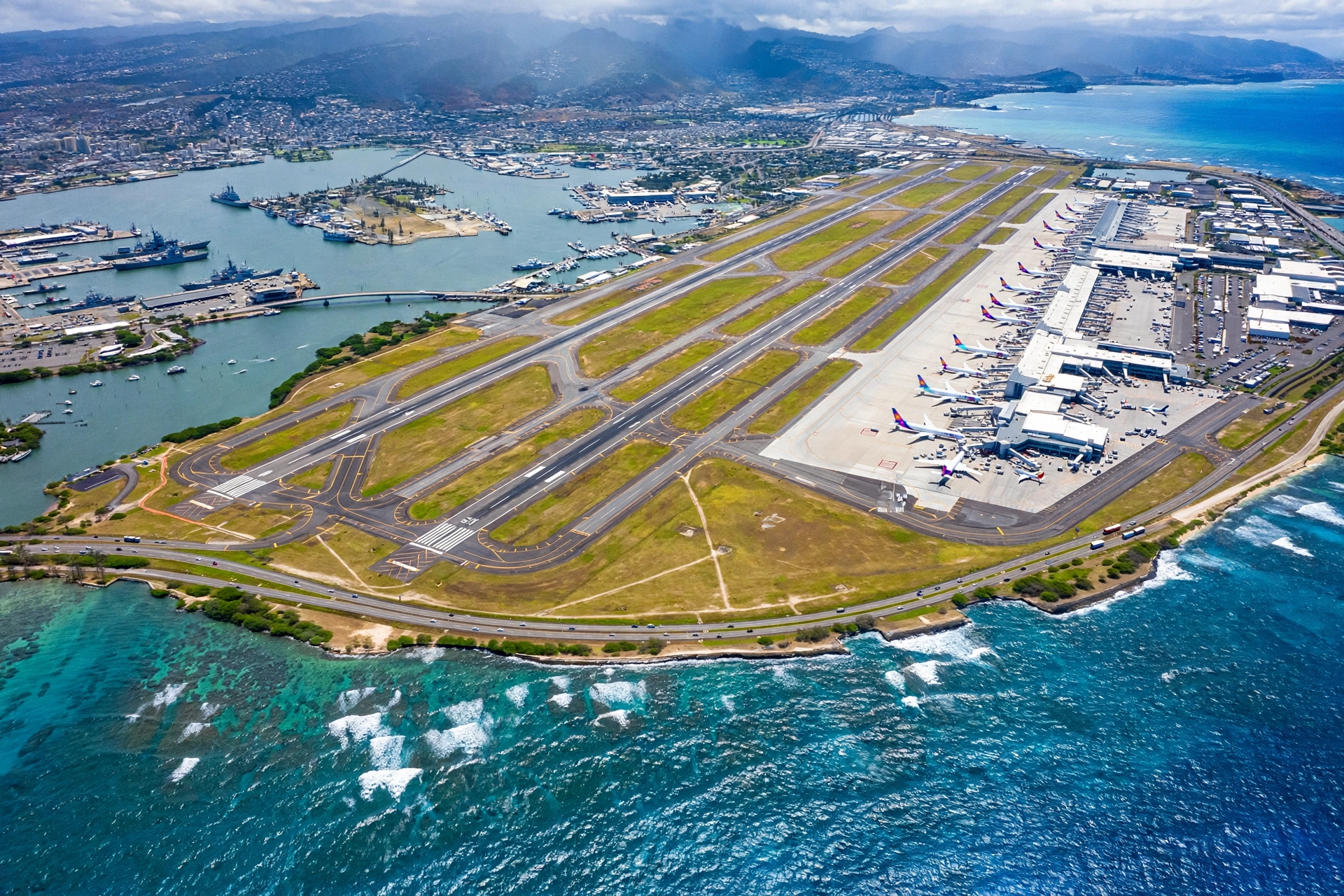
Daniel K. Inouye International Airport (HNL) sits on the south shore about 10 miles west of Waikīkī, between Pearl Harbor and downtown Honolulu. It is the main gateway to Hawaiʻi, handling the vast majority of transpacific flights and most interisland connections. The airport has three main terminal areas for domestic, international, and interisland flights, connected by a Wiki Wiki shuttle bus. The drive to Waikīkī takes 20 to 30 minutes in light traffic via the H-1 freeway, and rental car facilities are consolidated in a dedicated center with shuttle service from the terminals.
Getting around Oʻahu without a car is more feasible here than on any other island, but a rental car still unlocks the most. TheBus, the island’s public transit system, covers the island with routes that reach the North Shore, Windward Coast, and Leeward side, though frequencies drop outside Honolulu and a cross island trip can take two hours or more. Skyline, the elevated rail line, currently runs from East Kapolei to the stadium area with extensions toward the airport and downtown under construction. Taxis, rideshares, and hotel shuttles fill the gaps in the urban core. For most visitors, the practical formula is a rental car for the full stay or at least for the days with North Shore, Windward, or Leeward plans, with walking and TheBus covering Waikīkī and Honolulu itself.
Frequently Asked Questions
Where is Oʻahu located in the Hawaiian island chain?
Oʻahu is the third island from the northwest end of the main Hawaiian Islands, sitting between Kauaʻi to the northwest and Molokaʻi and Maui to the southeast. It is roughly 2,500 miles southwest of California, and Honolulu’s position near the middle of the North Pacific is what made it a natural crossroads for ships and later for aircraft.
How big is Oʻahu compared to the other islands?
Oʻahu covers about 597 square miles, making it the third largest island after the Big Island (about 4,028 square miles) and Maui (about 727 square miles). It is slightly larger than Kauaʻi (about 562 square miles). What it lacks in size it makes up in population: about one million residents, roughly two thirds of the state’s total.
What are the five regions of Oʻahu?
The island divides into Honolulu and the Southeast (the urban core and Waikīkī), the Windward Coast (the lush eastern side with Kāneʻohe and Kailua), the North Shore (the rural surf country around Haleʻiwa), the Leeward Coast (the dry western side with Waiʻanae and Ko Olina), and Central Oʻahu (the plantation plateau between the mountain ranges). Each region has its own weather, character, and set of attractions.
How long does it take to drive around Oʻahu?
A full circle island drive on Kamehameha and Farrington Highways covers roughly 120 miles and takes about 4 to 5 hours of driving time without stops. With stops at the Polynesian Cultural Center, Waimea Valley, Haleʻiwa, and the Windward lookouts, most travelers turn it into a full day of 8 to 10 hours. Starting early avoids both traffic and full parking lots.
Is it better to stay in Waikīkī or somewhere else on Oʻahu?
Waikīkī suits first time visitors who want walkability, dining variety, and easy access to tours, with the tradeoff of crowds and higher prices. Kailua suits beach lovers who want a quieter town with world class sand on foot. The North Shore suits surf culture fans and repeat visitors, with the tradeoff of longer drives to Honolulu sights. Ko Olina suits resort focused travelers who want guaranteed sunshine. Most visitors choose Waikīkī for a first trip and branch out on later ones.
Do I need a rental car on Oʻahu?
A rental car is strongly recommended for any itinerary that goes beyond Waikīkī and Honolulu. The North Shore, Windward Coast, and Leeward Coast are difficult to reach efficiently by bus, and the freedom to chase good weather across the island’s microclimates is one of the best parts of an Oʻahu trip. If your entire stay is Waikīkī plus one or two guided tours, you can manage without one.
When is the best time to visit the North Shore?
It depends on what you want. Winter, roughly November through February, brings the giant surf that made the North Shore famous, which is spectacular to watch but dangerous for swimming. Summer brings calm, clear water that is excellent for snorkeling and swimming at the same beaches. Spring and fall offer a mix. Check the surf forecast before any North Shore beach day regardless of season.
How far is Pearl Harbor from Waikīkī?
Pearl Harbor is about 13 miles west of Waikīkī, a 25 to 35 minute drive via the H-1 freeway in light traffic. The Pearl Harbor National Memorial includes the USS Arizona Memorial, the Battleship Missouri, the USS Bowfin, and the aviation museum, and most visitors spend at least half a day there. Advance reservations for the USS Arizona Memorial program are strongly recommended.
Can you see other islands from Oʻahu?
Yes. On clear days, Molokaʻi is visible from Oʻahu’s eastern and southeastern shores, including from the Makapuʻu Point Lighthouse Trail and parts of the Windward Coast. Lānaʻi is sometimes visible beyond Molokaʻi from high vantage points. Maui’s Haleakalā can occasionally be glimpsed from the highest ridges in exceptional conditions, though this is rare.
What is the rainiest part of Oʻahu?
The summit areas of the Koʻolau Range are among the wettest spots on earth, but for inhabited areas, the Windward Coast from Kāneʻohe to Waimānalo gets the most rain. The Leeward Coast around Waiʻanae and Kapolei gets the least. Honolulu and Waikīkī sit in between, with most rain falling in brief winter showers. This is why the Windward side is lush green and the Leeward side is dry and sunny.
Related Guides
- Oʻahu Beaches: detailed reviews of the island’s best beaches by coast and season
- Oʻahu Hikes: the island’s best trails, from Diamond Head to the Koʻolau ridges
- Waikīkī Walking Map: walking routes, districts, and landmarks in the resort zone
- Where Is Pearl Harbor on a Map: locating the memorial and planning the visit
- Hawaii Beach Map: how Oʻahu’s beaches fit into the statewide picture
- Hawaii Snorkeling: where Oʻahu’s reefs fit among the islands’ best snorkeling
- Hawaii Map: the full Hawaiian island chain in one reference
Reading Oʻahu Like a Local
The visitors who get the most out of Oʻahu are the ones who stop thinking of it as a single destination and start reading it as five small regions sharing one island. A morning can start with sunrise over the Mokulua islets in Lanikai, continue with shave ice in Haleʻiwa at midday, and end with sunset from a Waikīkī catamaran, and none of those drives is longer than an hour. The mountains in the middle are not an obstacle; they are the reason the island works this way, sorting rain, sun, surf, and towns into the pattern you now have on this map. Keep the regions in mind, watch the clock for traffic, check the surf before the North Shore, and Oʻahu will feel less like a place you visit and more like a place you navigate with confidence.