
Where Waikōloa Sits on the Map
Waikōloa sits on the Kohala Coast in South Kohala, on the dry leeward side of the Big Island of Hawaiʻi. If you picture the island as a rough triangle, Waikōloa occupies the west-facing shoreline about two thirds of the way up the western edge, roughly 18 miles north of Kailua-Kona and 12 miles north of Kona International Airport at Keāhole. To its north, the coast continues toward Hāpuna Beach, the Mauna Kea Resort area, and Kawaihae. To its south, the Queen Kaʻahumanu Highway runs back down through old lava fields toward the airport and Kona. Inland and uphill to the east, the land rises toward Waimea and the green ranch country of the Kohala Mountains.
The name Waikōloa covers two distinct places, and keeping them straight makes the map much easier to read. Waikōloa Beach Resort is the coastal resort district, a planned community built on old lava fields right at the shoreline, centered on ʻAnaehoʻomalu Bay. Waikōloa Village is a separate residential community set uphill and inland, about seven miles from the coast along Waikōloa Road, where most of the area’s year-round residents live. Visitors almost always mean the Beach Resort when they say Waikōloa, but the village matters because it holds the area’s everyday services: the supermarket, schools, medical offices, and a second golf course.
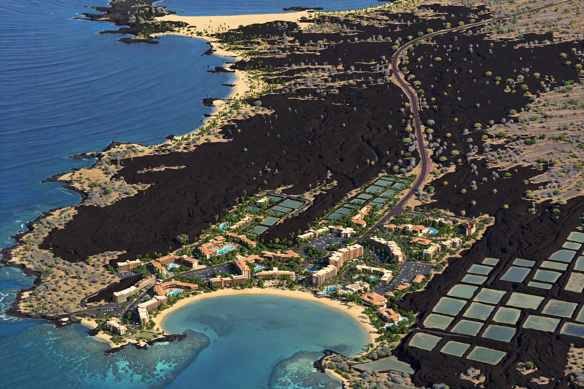
Geography shapes everything here. Waikōloa lies in the rain shadow of the Kohala Mountains and Mauna Kea, so it is one of the driest and sunniest stretches of the island, with annual rainfall often under ten inches at the coast. The resort itself was built on relatively young lava flows from Mauna Loa, including rock from the 1859 eruption that reached the sea nearby, which is why the ground under the hotels and shops is dark, rough ʻaʻā lava broken only by landscaping and pockets of native dry forest. That volcanic setting is part of the area’s character: black lava, white sand beaches, and bright blue water side by side.
On a Big Island road map, Waikōloa is easy to find because the coastal highway makes a long, nearly straight run along this part of the island. Look for the cluster of resort development between the airport to the south and Hāpuna Beach State Recreation Area to the north. The turnoff from the highway is Waikōloa Beach Drive, which drops toward the ocean and becomes the resort’s main street. Everything a visitor needs radiates from that one road.
The Resort Area, Laid Out
Waikōloa Beach Resort is a planned resort community, which means its layout is orderly in a way that older Hawaiian towns are not. Waikōloa Beach Drive is the spine. Coming from the Queen Kaʻahumanu Highway, the drive descends toward the sea, passing the turnoffs for the golf courses and residential neighborhoods before reaching the commercial heart of the resort: two open-air shopping centers, Kings’ Shops and Queens’ Marketplace, set on opposite sides of the road. These hold the area’s restaurants, shops, and services. They are ordinary commercial centers rather than attractions in themselves, but their position makes them the natural landmark for giving directions: nearly everything in the resort is described as mauka (toward the mountains) or makai (toward the sea) of this central point.
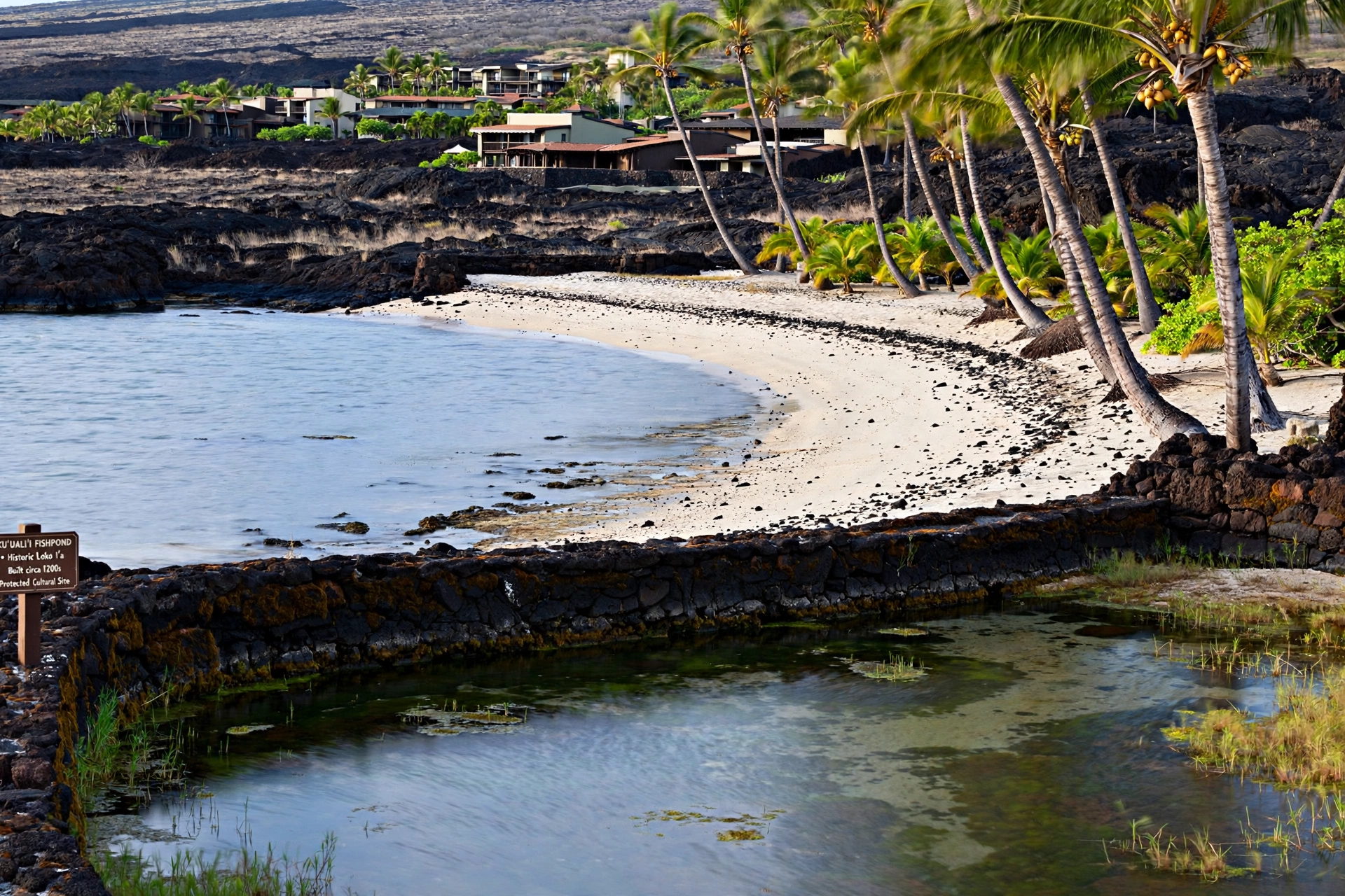
Makai of the shopping centers, the road continues to ʻAnaehoʻomalu Bay, universally called A-Bay, which is the geographic and social center of the resort. The bay curves in a gentle crescent, and its shoreline holds a public beach park with restrooms, showers, and shaded pavilions. Behind the beach stand two of the bay’s most historically significant features: the ancient Hawaiian fishponds of Kuʻualiʻi and Kahapapa. These royal fishponds were built centuries ago to raise fish for chiefs, and their low rock walls are still visible in the shallows. They are historic sites, not swimming spots, and visitors should admire them from the shore without walking on the walls or disturbing the water.
Resort hotels and condominium complexes line the shore north and south of A-Bay along the coastline. The shoreline between them is connected by a public coastal walkway, so it is possible to stroll along the water past the properties without trespassing. This walkway is one of the resort’s best features for non-guests: it links A-Bay with the quieter coves to the north and gives everyone access to the coast regardless of where they are staying.
Inland from the bay, the resort spreads across the lava fields in a grid of residential neighborhoods, two golf courses, and the Waikōloa Dry Forest Preserve, a protected remnant of the native dry forest that once covered this coast. The preserve is a reminder of what the landscape looked like before development, with native wiliwili trees and other dryland species surviving among the lava. Access is limited and managed for conservation, so check current guidance before visiting.
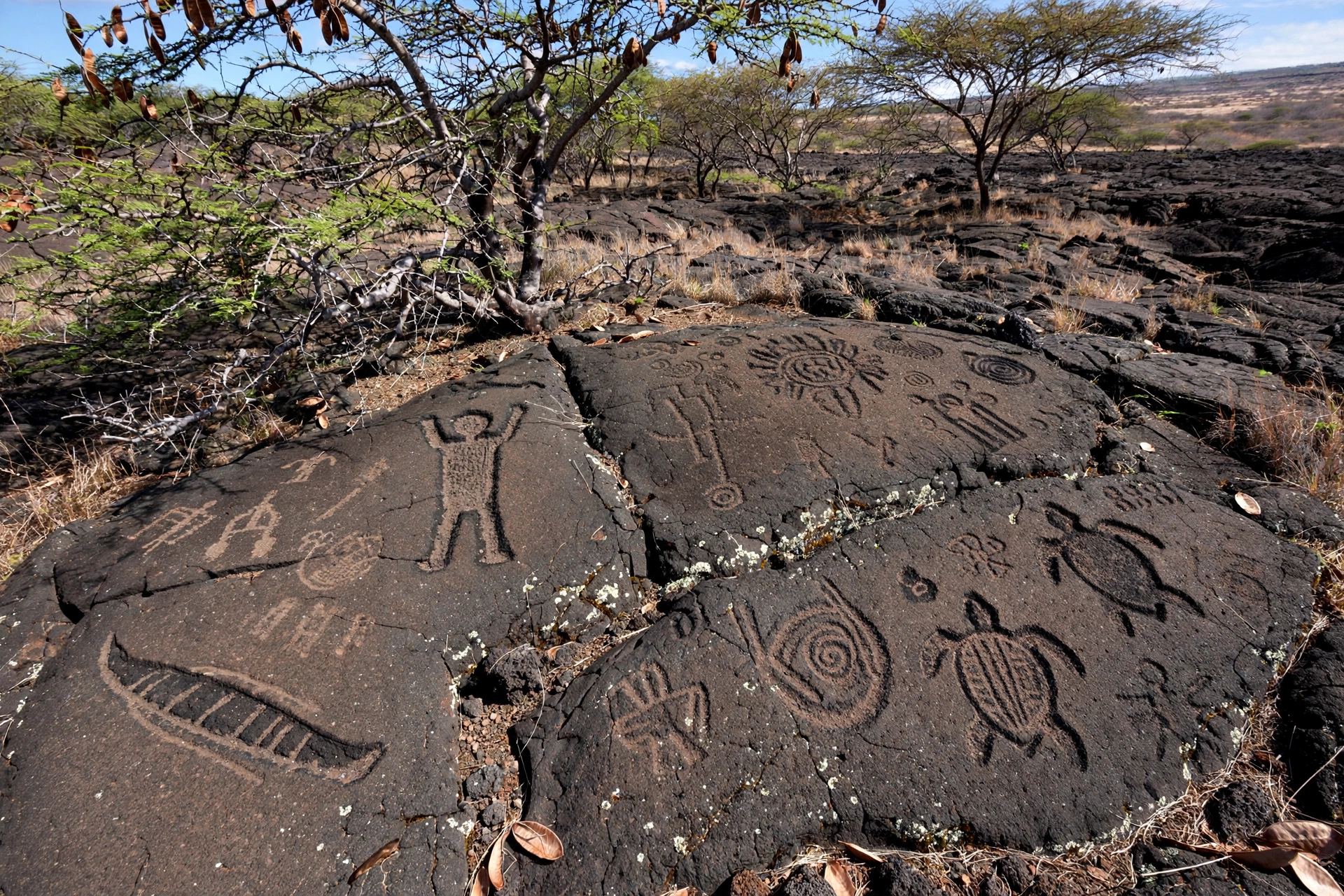
Just south of the resort, near the Mauna Lani area, the Puakō Petroglyph Archaeological Preserve protects more than a thousand ancient rock carvings reached by the Malama Trail, a short loop through a kiawe forest. The petroglyphs are one of the densest concentrations of ancient Hawaiian rock art on the island. Visitors should stay on the marked trail, never touch or trace the carvings, and bring water and sun protection because the trail is fully exposed.
Segments of the historic coastal trail known as the Ala Kahakai also pass through this shoreline, following routes that Hawaiians used for centuries before roads existed. Where the trail crosses resort land it is generally walkable, and it offers a completely different experience from the manicured resort grounds: rough lava, ocean spray, and long empty stretches of coast.
Beaches on the Map
The beach at ʻAnaehoʻomalu Bay is the home beach of the resort and the easiest sand to reach. It is a calm, protected crescent, good for swimming, stand-up paddling, and snorkeling along the rocky edges of the bay. Because the bay faces west and is sheltered, the water is usually gentle, though winter swells can still bring surf. The beach park has the practical things visitors need: parking, restrooms, outdoor showers, and shade from palm trees and pavilions. Arrive before mid-morning for the easiest parking, especially on weekends and holidays when local families join the visitors.
Five miles north of the resort, Hāpuna Beach State Recreation Area holds what many consider the finest white-sand beach on the Big Island. Hāpuna is a broad, half-mile crescent of light sand with clear water, lifeguards, restrooms, showers, picnic pavilions, and a concession area. It is a state park, so it has set hours and a parking fee for non-residents, and the lot can fill on busy days. The beach is beautiful but deserves respect: shorebreak can be powerful, especially during high surf, and swimmers should check conditions and stay near the lifeguard towers.
About ten miles north of Waikōloa, Kaunaʻoa Bay at the Mauna Kea Resort area is another famous crescent of white sand, consistently ranked among the world’s best beaches. Public access exists but is limited: the resort controls a small number of public parking passes issued each day at the gate, and once they are gone, visitors are turned away. The practical lesson is to arrive very early or have a backup plan, with Hāpuna as the reliable alternative just down the coast.
South of the resort, the coast toward the airport is mostly rocky lava shoreline with small pocket beaches rather than long stretches of sand. These coves can be lovely for snorkeling when the ocean is calm, but entries are over rock and urchins, so reef shoes and caution are wise. None of these spots have lifeguards or facilities, which makes them better for experienced ocean-goers than for casual swimming.
Ocean safety applies everywhere on this coast. There are no lifeguards at most beaches outside Hāpuna and the main resort swimming areas. Winter brings larger swells to west-facing shores, and even calm-looking water can have strong currents. Check the daily surf and ocean safety forecasts before swimming, never swim alone, and keep children within arm’s reach. For a fuller rundown of the island’s beaches, see the Big Island beaches guide.
Key Roads and Routes
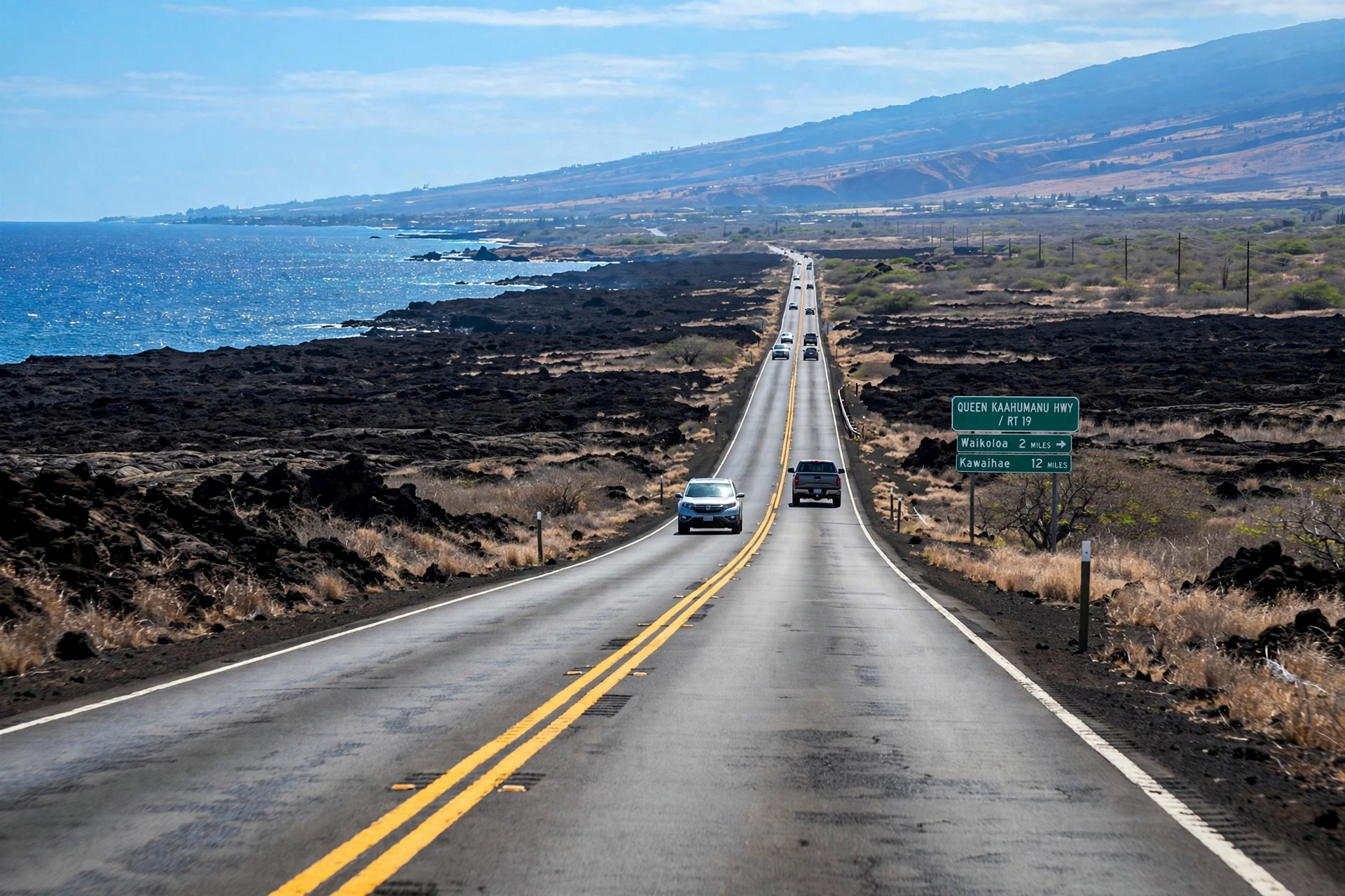
The Queen Kaʻahumanu Highway, Highway 19, is the road that defines this coast. It runs north-south along the shoreline from Kailua-Kona all the way to Kawaihae, passing the airport, Waikōloa, Hāpuna, and the Mauna Kea Resort turnoffs along the way. Almost every trip in the area starts or ends on this highway. It is a good divided highway for most of its length, with a 55 mph speed limit on the open stretches, and it moves quickly outside of rush hours. The main hazard is not traffic but distraction: the ocean views are spectacular, so use the signed scenic pullouts rather than slowing in the travel lane.
Waikōloa Beach Drive is the resort’s front door. It leaves Highway 19 at a signaled intersection, runs makai past the golf courses and residential areas, and ends at ʻAnaehoʻomalu Bay. Along the way it passes Kings’ Shops and Queens’ Marketplace, making it the single road visitors will use most. Paniolo Avenue branches off Waikōloa Beach Drive toward the residential neighborhoods and connects with Waikōloa Road, which climbs seven miles uphill to Waikōloa Village.
Waikōloa Road continues past the village and meets Highway 190, the Māmalahoa Highway, which is the upper route between Waimea and the Kona side. This gives drivers two ways to reach Waimea: the faster Highway 19 to Kawaihae and then up Highway 270, or Waikōloa Road to Highway 190, which is shorter in miles but slower and more winding. For trips to Hilo or Hawaiʻi Volcanoes National Park, most drivers take Highway 19 south to the airport junction and then follow Highway 200, the Saddle Road, across the island, which is the fastest cross-island route.
Distances from Waikōloa Beach Resort are straightforward. Kona International Airport is about 12 miles south, roughly a 20-minute drive. Kailua-Kona is about 18 miles south, around 25 to 30 minutes. Waimea is about 16 miles northeast, roughly 25 minutes. Hāpuna Beach is about five miles north. Hilo is about 75 miles via Saddle Road, roughly an hour and 45 minutes, and Hawaiʻi Volcanoes National Park is about 100 miles, roughly two and a half hours. Fuel up before long drives: the resort area has gas stations, but the stretches of highway in both directions have few services.
Nearby Areas Worth Knowing
Hāpuna and the North Kohala Coast
North of Waikōloa, the coast stays dry and sunny past Hāpuna Beach State Recreation Area to the Mauna Kea Resort area and on to Kawaihae, a small harbor town with deep historical roots. Kawaihae is the gateway to Puʻukoholā Heiau National Historic Site, the massive stone temple Kamehameha the Great built in the 1790s before unifying the islands. The heiau is a short drive from the harbor, and the national park site includes a visitor center that explains its history. This stretch of coast rewards drivers who continue past the resort zone: the beaches get quieter and the history gets older.
Waimea and Paniolo Country
Inland from Waikōloa, Waimea (also called Kamuela) sits at about 2,700 feet elevation and feels like a different island entirely: green pastures, cool air, and the paniolo (Hawaiian cowboy) culture centered on Parker Ranch, one of the largest cattle ranches in the United States. Waimea is the practical stop for visitors based in Waikōloa: it has the island’s best-stocked supermarkets, a Saturday farmers market, and a concentration of restaurants. The drive up from the coast takes about 25 minutes and climbs through changing vegetation zones, which is a scenic trip in itself. See the Kohala guide for more on the region.
Kailua-Kona to the South
South along Highway 19, Kailua-Kona is the historic seaside town that serves as the commercial center of the west side. It holds the area’s largest concentration of shops, restaurants, and services, plus historic sites like Huliheʻe Palace and the Mokuʻaikaua Church. Many visitors split their time between Waikōloa’s beaches and Kona’s town life, and the 25-minute drive between them is easy. The airport sits between the two, which makes Waikōloa slightly closer to arriving flights than Kona town itself.
Puakō and Mauna Lani
Immediately south of Waikōloa Beach Resort, the shoreline continues through Puakō, a quiet residential beach community, and the Mauna Lani resort area. Puakō’s coast is rocky with excellent snorkeling when calm, and the petroglyph preserve sits just inland. This area is worth knowing because it extends the walkable and drivable coastline south of the resort without requiring a highway trip, and it holds some of the island’s best shore snorkeling on calm summer mornings.
Navigating Waikōloa Day to Day
A rental car is effectively required. The resort area is spread out, the beaches and attractions lie miles apart along the highway, and public bus service is limited. Book the car with your flights, because the airport rental lots can sell out during busy periods. Once you have it, navigation is simple: Highway 19 is the north-south axis, Waikōloa Beach Drive is the spur to the resort, and everything else branches from those two.
Parking is free and generally plentiful at the resort’s public beach parks, though ʻAnaehoʻomalu Bay’s lot fills on weekends and holidays. The shopping centers have large free lots. At Hāpuna, arrive early or be prepared to wait for the state park lot to turn over. At Kaunaʻoa Bay, the limited public passes mean an early arrival is not optional but necessary.
The sun is the main environmental factor to plan around. This is one of the sunniest coasts in the state, and the lava landscape reflects heat. Carry water on every outing, wear reef-safe sunscreen, and plan hikes and walks for the morning. The petroglyph trail, the coastal walkway, and the Ala Kahakai segments have little to no shade. Afternoon clouds sometimes build over the mountains and drift toward the coast, but they cannot be counted on.
Within the resort, walking and biking are pleasant. The coastal walkway links the bay with the shoreline neighborhoods, and the resort’s internal roads have sidewalks. Bicycles can be rented in the shopping centers for getting around without moving the car. For anything beyond the resort, including Hāpuna, Waimea, and Kona, driving is the only practical option.
Frequently Asked Questions
Where is Waikōloa in Hawaiʻi?
Waikōloa is on the Kohala Coast in South Kohala, on the west side of the Big Island of Hawaiʻi, about 18 miles north of Kailua-Kona and 12 miles north of Kona International Airport. It sits on the dry, sunny leeward coast between the airport to the south and Hāpuna Beach to the north.
Is Waikōloa a town?
Not exactly. Waikōloa Beach Resort is a planned resort community, and Waikōloa Village is a separate residential community about seven miles inland. Neither is an incorporated town in the mainland sense. The area functions as a resort district rather than a traditional Hawaiian town like Hāwī or Honokaʻa.
How far is Waikōloa from the Kona airport?
About 12 miles, roughly a 20-minute drive north on the Queen Kaʻahumanu Highway (Highway 19). It is one of the closest resort areas to the airport on the island.
What is there to do in Waikōloa besides the beach?
The area has two golf courses, the Puakō petroglyph preserve nearby, the historic fishponds at ʻAnaehoʻomalu Bay, a coastal walkway, shopping and dining at Kings’ Shops and Queens’ Marketplace, and easy day trips to Waimea, Puʻukoholā Heiau, and Hāpuna Beach. Snorkeling, stand-up paddling, and outrigger canoe paddling are popular on calm mornings.
Which beach near Waikōloa is best for swimming?
ʻAnaehoʻomalu Bay is the calmest and most convenient, right in the resort. For the finest sand and clearest water, Hāpuna Beach State Recreation Area five miles north is the standout, with lifeguards and full facilities. Kaunaʻoa Bay is equally beautiful but has very limited public parking.
What is the difference between Waikōloa Beach Resort and Waikōloa Village?
The Beach Resort is the coastal resort district with hotels, condos, beaches, golf, and shopping. The Village is a residential community about seven miles inland and uphill, where most local workers live, with a supermarket, schools, and everyday services. Visitors stay at the Beach Resort; the Village is useful for groceries and local-priced services.
Can you get around Waikōloa without a car?
Within the resort itself, yes: the area is walkable and bikeable, with a coastal walkway and sidewalks. But reaching Hāpuna, Waimea, Kona, the airport, or anywhere else on the island requires a car. Public transit is limited, so a rental car is effectively essential for a Waikōloa-based trip.
Is Waikōloa a good base for exploring the Big Island?
It is an excellent base for the west side: beaches, Kohala, Waimea, and Kona are all within 30 minutes, and the airport is 20 minutes away. For the east side, including Hawaiʻi Volcanoes National Park and Hilo, expect drives of two hours or more each way, so plan those as full-day trips or overnight stays.
Related Guides
- Where Is Kohala in Hawaiʻi
- Where Is the Big Island in Hawaiʻi
- Big Island Hawaiʻi Beaches
- Hawaiʻi Map
- Big Island Hawaiʻi Weather
- Best Time to Visit Hawaiʻi
A Final Note on Reading the Waikōloa Map
Waikōloa rewards visitors who understand its layout before they arrive. The resort, the village, the highway, and the neighboring coasts each play a different role, and the map makes sense once those pieces are in place: one coastal highway, one resort spur road, beaches strung along the shore to the north, ranch country rising inland to the east. With that picture in mind, the area is easy to navigate and hard to get wrong. The lava fields that look empty on the map hold a thousand years of Hawaiian history, from fishponds to petroglyphs to the trails that connected it all, and the modern resort sits lightly on top of that older landscape. Knowing both layers is what turns a beach stay into an understanding of the place.