
Hawaiʻi Kai on the Map
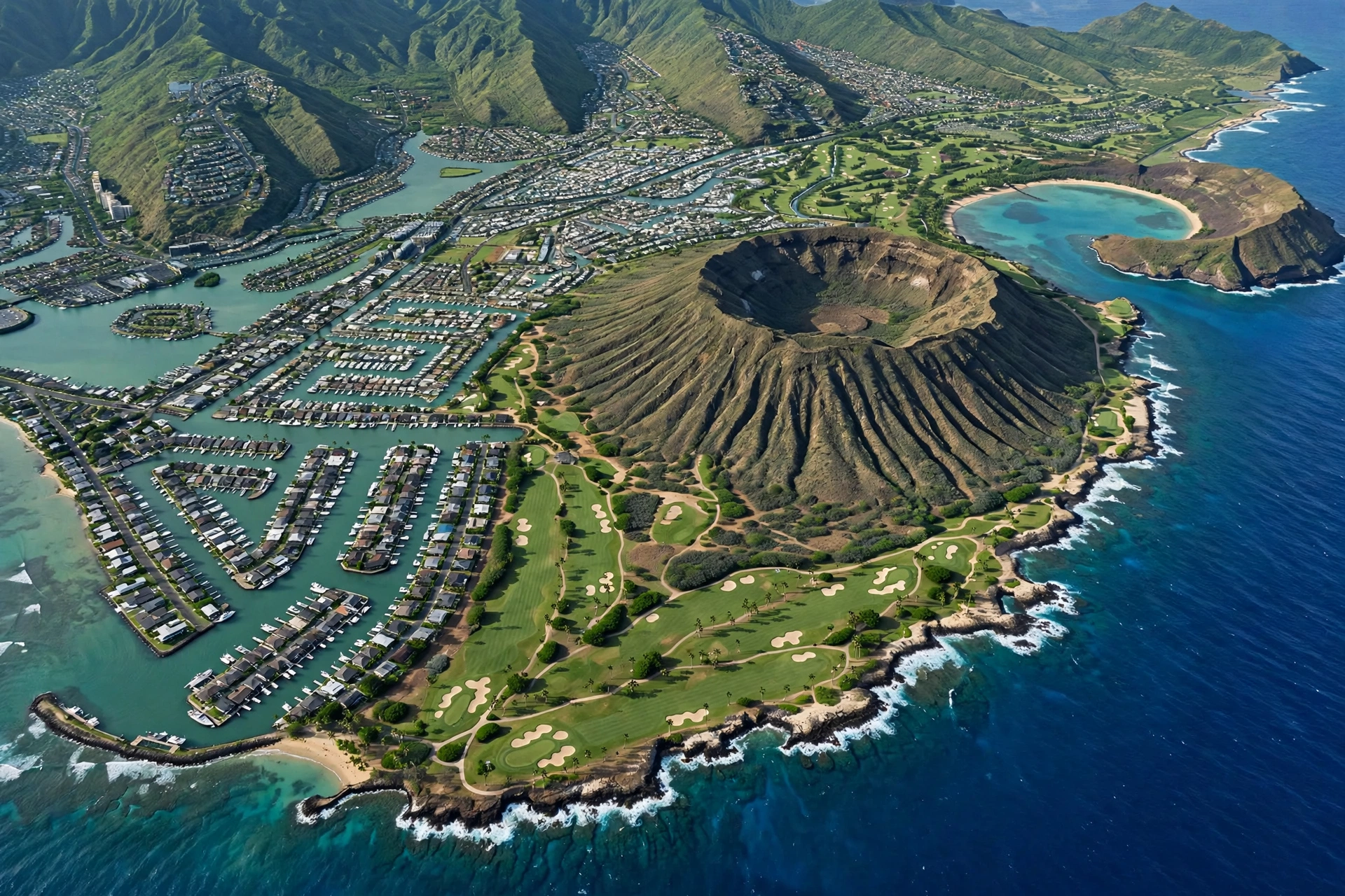
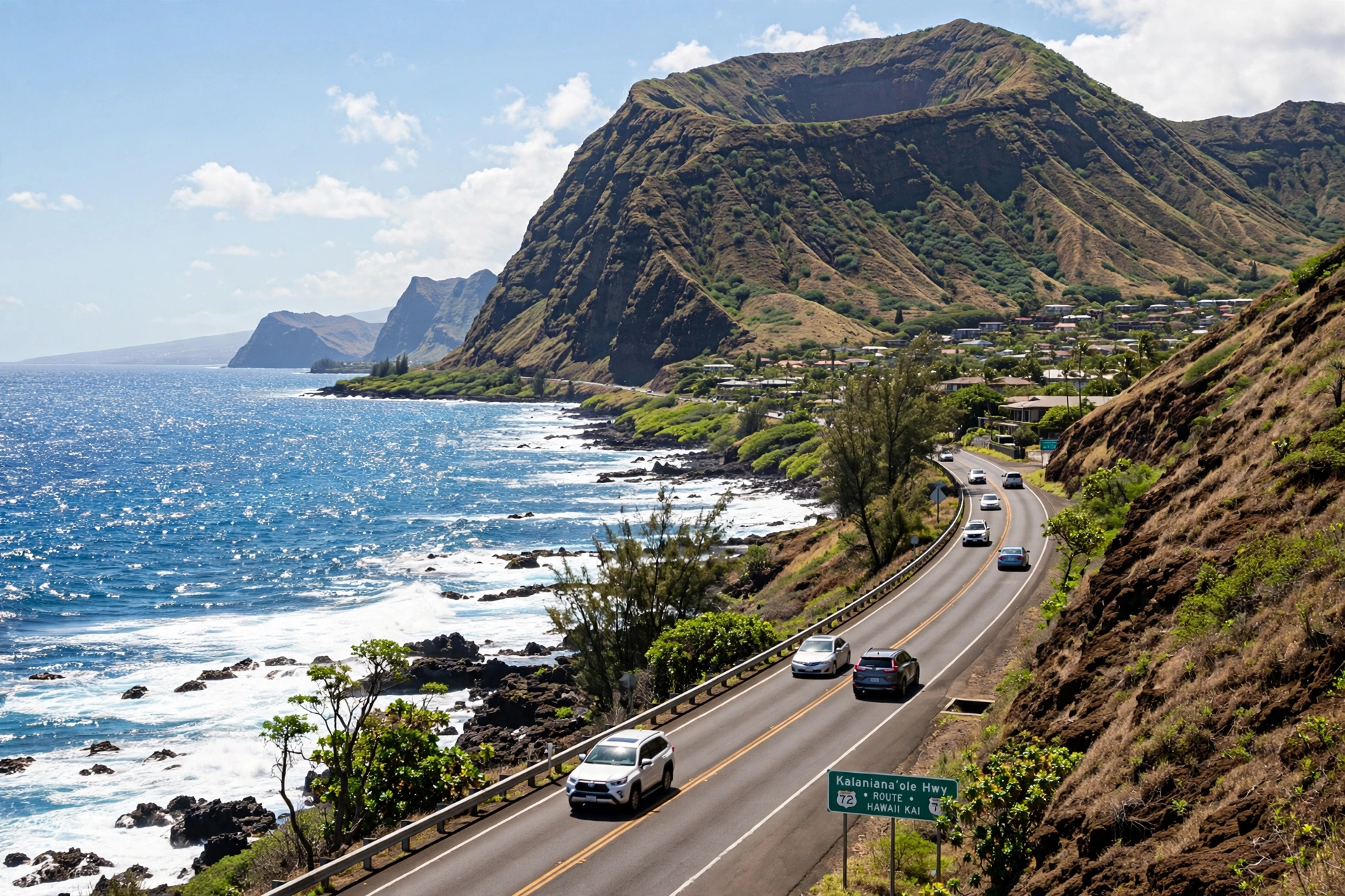
Hawaiʻi Kai sits on the southeastern coast of Oʻahu, in East Honolulu, roughly 13 miles east of Waikīkī along the Kalanianaʻole Highway. It is the last major residential community before the highway climbs toward Makapuʻu Point and the island’s windward side, which makes it a natural landmark on any map of southeastern Oʻahu. To the west lies ʻĀina Haina and Niu Valley; to the east, the highway passes Hanauma Bay, then continues past Sandy Beach Park and Makapuʻu toward Waimānalo. Behind the neighborhood to the north rise the Koʻolau mountains, and the prominent volcanic cone of Koko Crater, often called Koko Head, anchors the eastern edge of the community.
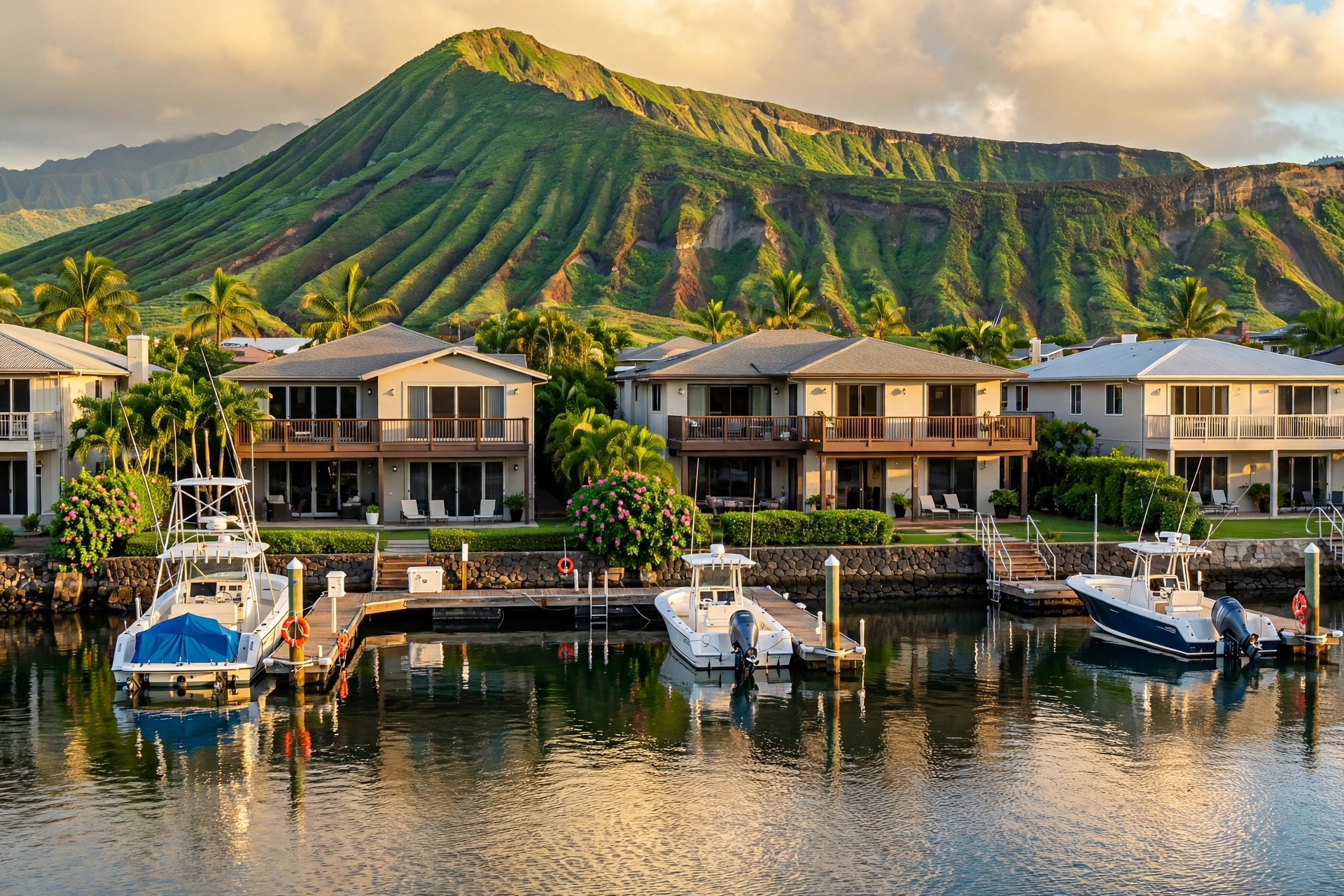
On a map, Hawaiʻi Kai is easy to recognize by its marina. The Hawaiʻi Kai Marina is a dredged inland waterway lined with waterfront homes, and it gives the neighborhood its distinctive shape. The community spreads from the marina toward the mountains in a series of valleys and ridges: Kalama Valley to the west, and the Queen’s Gate, Mariners Ridge, and Kamilo Nui areas climbing the slopes behind. The Hawaiʻi Kai Golf Course occupies the eastern portion of the neighborhood, tucked against the base of the Makapuʻu ridge and the sand dunes behind the Kaʻiwi shoreline, between the marina district and Sandy Beach Park.
The area’s geography explains why it became both a residential community and a golf destination. The land between the marina and the Kaʻiwi coast was once the Kuapā fishpond, one of the largest ancient Hawaiian fishponds, covering more than 500 acres. In the 1960s, developer Henry J. Kaiser transformed the area, dredging the marina and building the residential community that exists today. The golf course, which opened in 1973, was laid out on the eastern flats where the terrain offered enough room for a full championship layout with mountain and ocean views in nearly every direction.
For visitors reading a map of Oʻahu, Hawaiʻi Kai’s position is practical to understand. It sits roughly halfway between Waikīkī and the island’s southeastern attractions. Hanauma Bay is about ten minutes east by car. Koko Crater and its famous stair hike are within the neighborhood itself. The drive from Honolulu International Airport takes about 30 to 40 minutes depending on traffic, and the route follows the H-1 freeway east until it becomes the Kalanianaʻole Highway. Because the highway continues all the way around Makapuʻu to Waimānalo and Kailua, Hawaiʻi Kai works well as a starting point for a full day exploring the island’s southeast and windward coasts.
The Golf Courses
The Hawaiʻi Kai Golf Course, located at 8902 Kalanianaʻole Highway in Honolulu, is a public facility with two distinct courses: the Championship Course and the Executive Course. Both sit on the same property at the eastern end of the Hawaiʻi Kai neighborhood, and together they make the facility one of the more versatile public golf options on Oʻahu. The course is open to the public, and its coastal setting gives it a character quite different from the resort courses on the island’s leeward side.
The Championship Course
The Championship Course is an 18-hole, par 72 layout designed by William Bell, the architect behind a number of well-known Hawaiʻi courses. It opened in 1973 and measures roughly 6,500 yards from the blue tees, with additional tee options at about 6,200 and 5,600 yards. The course carries a rating of 71.4 and a slope of 123 from the back tees, which places it in the moderately challenging range for a public course.
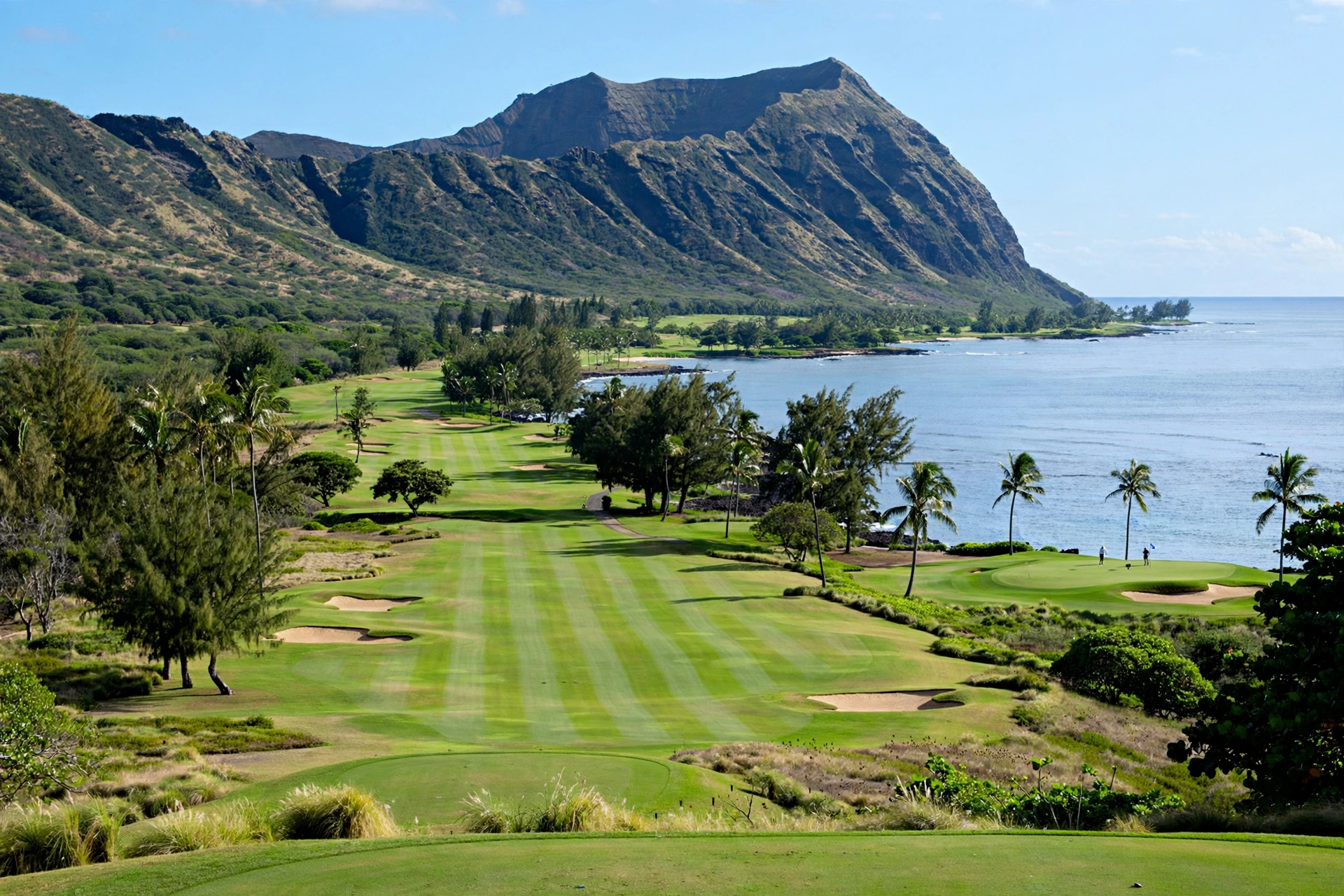
The layout takes advantage of its setting at the base of the Makapuʻu ridge. Elevation changes run through the round, and several dogleg holes ask golfers to shape shots around the terrain rather than simply hitting straight. The greens are Bermuda grass, as are the fairways, which is standard for Hawaiʻi courses and plays firm and fast in the dry southeastern climate. Water comes into play on several holes, and deep bunkers guard the approaches to many greens. The course is known for having particularly large greens, which rewards confident putting but can punish a misread.
Wind is the defining feature of the Championship Course. The trade winds sweep across the Kaʻiwi shoreline and the open eastern holes, and they can change a hole’s character completely from one day to the next. Golfers playing into the wind routinely need more club than the yardage suggests, and the exposed holes near the coast demand low, controlled ball flights. The inland holes, tucked closer to the ridge, offer some shelter but still catch gusts funneled through the valleys.
The views are the course’s signature. From the elevated holes, golfers look out across the Pacific toward Molokaʻi and, on clear days, Lānaʻi on the horizon. The Makapuʻu ridge rises directly behind several fairways, and Koko Crater is visible from much of the property. The highest point on the course offers a sweeping panorama of the coastline stretching from Sandy Beach Park toward Makapuʻu Point. These views are part of why the course has remained popular for more than five decades despite its no-frills, local character.
The Executive Course
The Executive Course is an 18-hole par 3 layout designed by Robert Trent Jones, one of the most influential golf architects of the twentieth century. It was created for beginning golfers, juniors, and anyone wanting to sharpen iron and short-game skills in a relaxed setting. The course overlooks the eastern shoreline, with views toward the Makapuʻu lighthouse and the ocean beyond.
Because every hole is a par 3, a round on the Executive Course takes considerably less time than a full championship round, which makes it a practical option for families, new golfers, or anyone fitting golf into a busy sightseeing day. The shorter holes still demand real shot-making: the greens are genuine targets, the wind affects every shot, and the layout was designed by an architect who understood that a short course should be interesting rather than trivial.
Facilities and Practical Details
The facility includes a driving range and short-game practice areas, a pro shop, a clubhouse with a restaurant and bar, and banquet facilities used for events. Golf carts are available, and club rentals are offered on site. The dress code calls for proper golf attire, and only soft-spike shoes are permitted on the courses. Yardage markers on the Championship Course use hibiscus trees at the 150-yard points, a small local touch.
Golfers planning a visit should know that the course operates as a busy public facility popular with local players, so weekend mornings fill early. The phone number for the pro shop is (808) 395-2358, and tee times are generally recommended, especially for the Championship Course. Walking is not the norm here; most play is by cart. The dry, sunny climate of southeastern Oʻahu means sunscreen and water are essential, and morning rounds offer the calmest wind conditions.
The Hawaiʻi Kai Neighborhood
Hawaiʻi Kai is primarily a residential community, and understanding the neighborhood helps visitors read the map around the golf course. The community was developed beginning in the 1960s by Henry J. Kaiser, whose company dredged the marina from the ancient Kuapā fishpond and built the waterfront neighborhoods, shopping areas, and roadways that define the area today. Before development, the Kuapā fishpond was among the largest in Hawaiʻi, a walled coastal fishpond whose stone walls enclosed hundreds of acres of shallow water used for raising fish.
Today the neighborhood is one of East Honolulu’s most established residential areas, with a mix of waterfront homes along the marina, townhome communities, and hillside neighborhoods climbing toward the Koʻolau range. The commercial heart of the area sits along Keahole Street and the Kalanianaʻole Highway, where shopping centers, grocery stores, and restaurants serve the local population. The Hawaiʻi Kai Towne Center and nearby Koko Marina Center are the main retail hubs.
The marina itself remains central to the neighborhood’s identity. It is a working small-boat harbor where residents keep boats, and the marina’s channels connect to Maunalua Bay through an ocean entrance. Paddlers and boaters use the marina, and the waterfront pathways are popular with walkers and joggers. For visitors, the marina area offers a glimpse of everyday life in East Honolulu that feels far removed from the resort corridors of Waikīkī.
Several distinct residential pockets make up the wider Hawaiʻi Kai area. Kalama Valley, at the western edge, holds a mix of older homes and newer development. The ridges above the marina, including Mariners Ridge and Hawaiʻi Loa Ridge, offer panoramic views across Maunalua Bay toward Diamond Head and the Waianae range. Queen’s Gate and Kamilo Nui sit closer to the golf course on the eastern side. Each area has its own character, but all share the neighborhood’s defining traits: ocean proximity, mountain views, and a suburban pace.
Visitors should understand that Hawaiʻi Kai is not a tourist district. There are no large resort hotels in the neighborhood, and the dining and shopping scene caters mainly to residents. That is part of its appeal for travelers who want to see how people live on Oʻahu beyond the visitor zones. The neighborhood’s parks, waterfront paths, and local eateries offer an unhurried counterpoint to busier parts of the island.
Nearby Attractions
One of Hawaiʻi Kai’s greatest advantages on the map is its position near some of Oʻahu’s most visited natural attractions. Within a short drive in either direction, visitors can reach beaches, hikes, and scenic lookouts that rank among the island’s best. What makes the area unusual is the density of these attractions: within roughly fifteen minutes of the golf course clubhouse, a visitor can stand on a volcanic crater rim, snorkel a protected reef, watch shorebreak pound a famous beach, and scan the horizon for whales. Few neighborhoods on Oʻahu pack this much variety into such a compact stretch of coastline, and the Kalanianaʻole Highway ties them all together in a single scenic corridor that is easy to navigate even for first-time visitors.
Hanauma Bay Nature Preserve
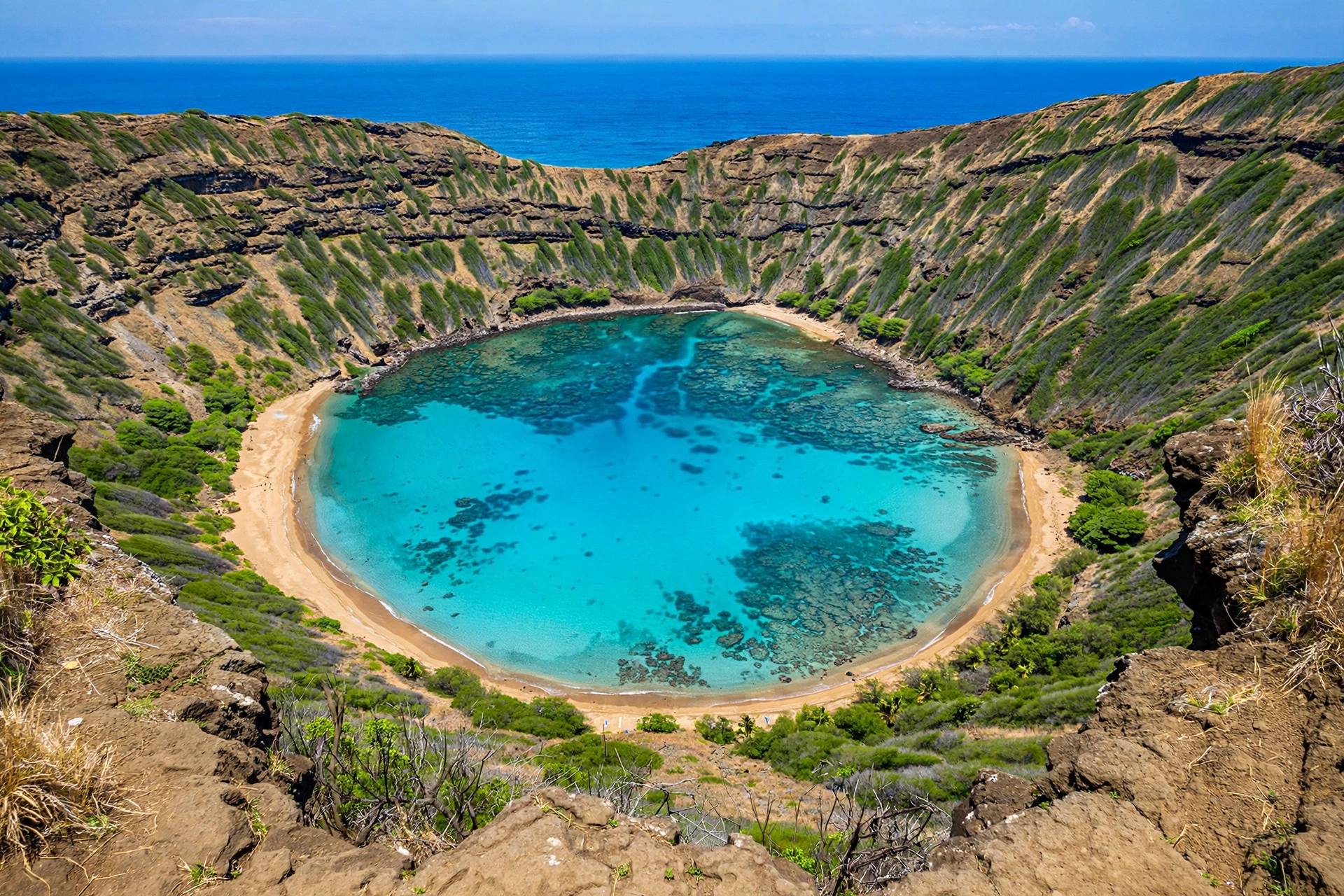
About ten minutes east of the golf course along the Kalanianaʻole Highway lies Hanauma Bay, Oʻahu’s most famous snorkeling destination. The bay is a flooded volcanic crater whose curved beach and clear, shallow reef make it ideal for observing marine life. It is a protected nature preserve, and all visitors watch an orientation video about reef conservation before entering. Reservations are required and the bay is closed certain days of the week, so visitors should check current rules with the City and County of Honolulu before planning a trip. The preserve’s popularity means parking and entry slots fill early.
Koko Crater and the Koko Head Stairs
Rising directly within the Hawaiʻi Kai area, Koko Crater is the neighborhood’s most prominent landmark. The Koko Head Stairs, sometimes called the Koko Crater Railway Trail, climb the crater’s slope along an old military railway tramway: more than a thousand railroad ties form a steep staircase to the summit. The hike is strenuous and fully exposed to the sun, with no shade and no water along the route. From the top, hikers earn panoramic views across Hanauma Bay, the Hawaiʻi Kai coastline, and on clear days the neighboring islands. The trailhead sits within the Koko Head District Park, and the hike is free.
Sandy Beach Park
Just east of the golf course, past the end of the residential area, Sandy Beach Park is one of Oʻahu’s most famous bodyboarding and bodysurfing beaches. The beach is known for powerful shorebreak waves that break close to shore, which makes it exciting to watch but dangerous for casual swimming. Strong currents and the pounding shorebreak have earned it a serious reputation, and lifeguards staff the beach. Visitors who do not bodyboard often come simply to watch skilled local riders. The park has restrooms, showers, and picnic areas, and its location right off the highway makes it an easy stop.
Makapuʻu Point and the Lighthouse Trail
Continuing east past Sandy Beach, the highway climbs toward Makapuʻu Point, the island’s easternmost tip. The Makapuʻu Point Lighthouse Trail is a paved, family-friendly path that climbs to a lookout above the historic lighthouse, which was built in 1909 and remains an active aid to navigation. From the trail’s viewpoints, visitors can see the offshore islets of Mānana, known as Rabbit Island, and Kaohikaipu. During the winter months, the lookout is one of Oʻahu’s best land-based whale-watching spots. Tide pools at the base of the cliffs are reachable by a rough side trail, but ocean conditions there can be dangerous.
Halona Blowhole and the Kaʻiwi Shoreline
Between Hanauma Bay and Sandy Beach, the Halona Blowhole lookout sits atop the lava cliffs of the Kaʻiwi shoreline. When surf surges into the lava tube below, water erupts through the blowhole in dramatic plumes. The adjacent Halona Beach Cove, a small pocket beach below the lookout, is a popular swimming and snorkeling spot when conditions are calm. The Kaʻiwi State Scenic Shoreline preserves the open coastal landscape between the golf course and Makapuʻu, and its trails offer quiet walks along the cliffs with sweeping ocean views.
Getting There
Reaching Hawaiʻi Kai and its golf course is straightforward. From Waikīkī, drivers take the H-1 freeway east, which becomes the Kalanianaʻole Highway (Route 72) after the ʻĀina Haina area. The golf course sits on the right side of the highway at 8902 Kalanianaʻole Highway, just before the road continues toward Hanauma Bay and Sandy Beach. The drive from Waikīkī takes about 25 to 35 minutes in normal traffic, though rush-hour congestion on the H-1 can add significant time.
From Honolulu International Airport, the route follows the H-1 east through downtown Honolulu and past Diamond Head, then continues as the Kalanianaʻole Highway into Hawaiʻi Kai. Allow 30 to 45 minutes depending on traffic. From the windward side, drivers can reach Hawaiʻi Kai via the Kalanianaʻole Highway around Makapuʻu Point, a scenic coastal drive that passes the lighthouse lookout and Sandy Beach.
Public transportation reaches the area via TheBus, Honolulu’s public bus system, which runs routes along the Kalanianaʻole Highway through Hawaiʻi Kai. However, a rental car is the most practical way to explore the area and its spread-out attractions, from the golf course to Hanauma Bay to the Makapuʻu lookouts. Parking at the golf course is free and plentiful. Visitors combining golf with beach stops should note that parking at Hanauma Bay and Sandy Beach fills early on weekends and holidays.
For golfers, morning tee times offer the calmest conditions before the trade winds strengthen in the afternoon. The course’s southeastern exposure means sun protection is important year-round. Visitors staying in Waikīkī or Honolulu can comfortably play a morning round and still have the afternoon free for the nearby beaches and lookouts, which is one of the practical advantages of the course’s location. Those pairing golf with a Hanauma Bay visit should plan the bay for a separate morning, since its reservation system and early entry slots do not mix well with a mid-morning tee time. A relaxed itinerary might put the Executive Course and Sandy Beach on the same afternoon, when the shorter round leaves plenty of daylight for the shoreline.
Frequently Asked Questions
Where is the Hawaiʻi Kai Golf Course located?
The course is at 8902 Kalanianaʻole Highway in Honolulu, in the Hawaiʻi Kai neighborhood of East Honolulu on Oʻahu’s southeast coast. It sits about 13 miles east of Waikīkī, between the Hawaiʻi Kai Marina district and Sandy Beach Park, at the base of the Makapuʻu ridge.
How many courses are at Hawaiʻi Kai Golf Course?
There are two: the 18-hole, par 72 Championship Course designed by William Bell, and the 18-hole par 3 Executive Course designed by Robert Trent Jones. The Championship Course is the full-length layout; the Executive Course is shorter and suited to beginners, juniors, and short-game practice.
Is the Hawaiʻi Kai Golf Course public?
Yes. It is a public golf facility open to everyone, and it is popular with local Oʻahu golfers as well as visitors. Tee times are recommended, especially on weekends.
What is Hawaiʻi Kai known for besides golf?
The neighborhood is known for its marina community, its location near Hanauma Bay, the Koko Head Stairs hike up Koko Crater, Sandy Beach Park, and the Makapuʻu Point Lighthouse Trail. It was developed in the 1960s by Henry J. Kaiser on the site of the ancient Kuapā fishpond.
How far is Hawaiʻi Kai from Waikīkī?
About 13 miles east, roughly a 25 to 35 minute drive via the H-1 freeway and Kalanianaʻole Highway in normal traffic. Rush-hour traffic can make the trip considerably longer.
Can beginners play at Hawaiʻi Kai?
The Executive Course, an 18-hole par 3 layout, was designed for beginning golfers, juniors, and short-game practice. The Championship Course is a full-length par 72 that suits more experienced players, though its multiple tee options make it playable for a range of skill levels.
What is near the golf course?
Hanauma Bay Nature Preserve is about ten minutes east. Sandy Beach Park is just east along the highway. The Koko Head Stairs trailhead is within the neighborhood. The Makapuʻu Point Lighthouse Trail and Halona Blowhole are a short drive further east.
Do I need a reservation for Hanauma Bay?
Hanauma Bay requires advance reservations for entry, and it is closed on certain days of the week. Rules and schedules can change, so check the City and County of Honolulu’s current information before visiting.
Related Guides
- Where Is Oʻahu Located in Hawaiʻi
- Waikīkī, Hawaiʻi
- Where Is Mānoa in Hawaiʻi
- Hawaiʻi Map
- Best Time to Visit Hawaiʻi
A Final Note
Hawaiʻi Kai rewards visitors who look beyond the fairways. The golf course anchors the eastern end of a neighborhood that holds some of Oʻahu’s most distinctive landscapes: a dredged marina where an ancient fishpond once lay, a volcanic crater climbed by thousands of hikers, a curved bay that shelters one of the world’s most visited reefs, and a shoreline where the trade winds meet the open Pacific. Reading the area on a map, from the marina’s channels to the golf course’s fairways to the lookouts past Sandy Beach, gives a clear picture of how geology, history, and modern development layered together on this corner of the island. It is a part of Oʻahu where the map itself tells much of the story.