
Haleʻiwa on the Map: Position and Setting
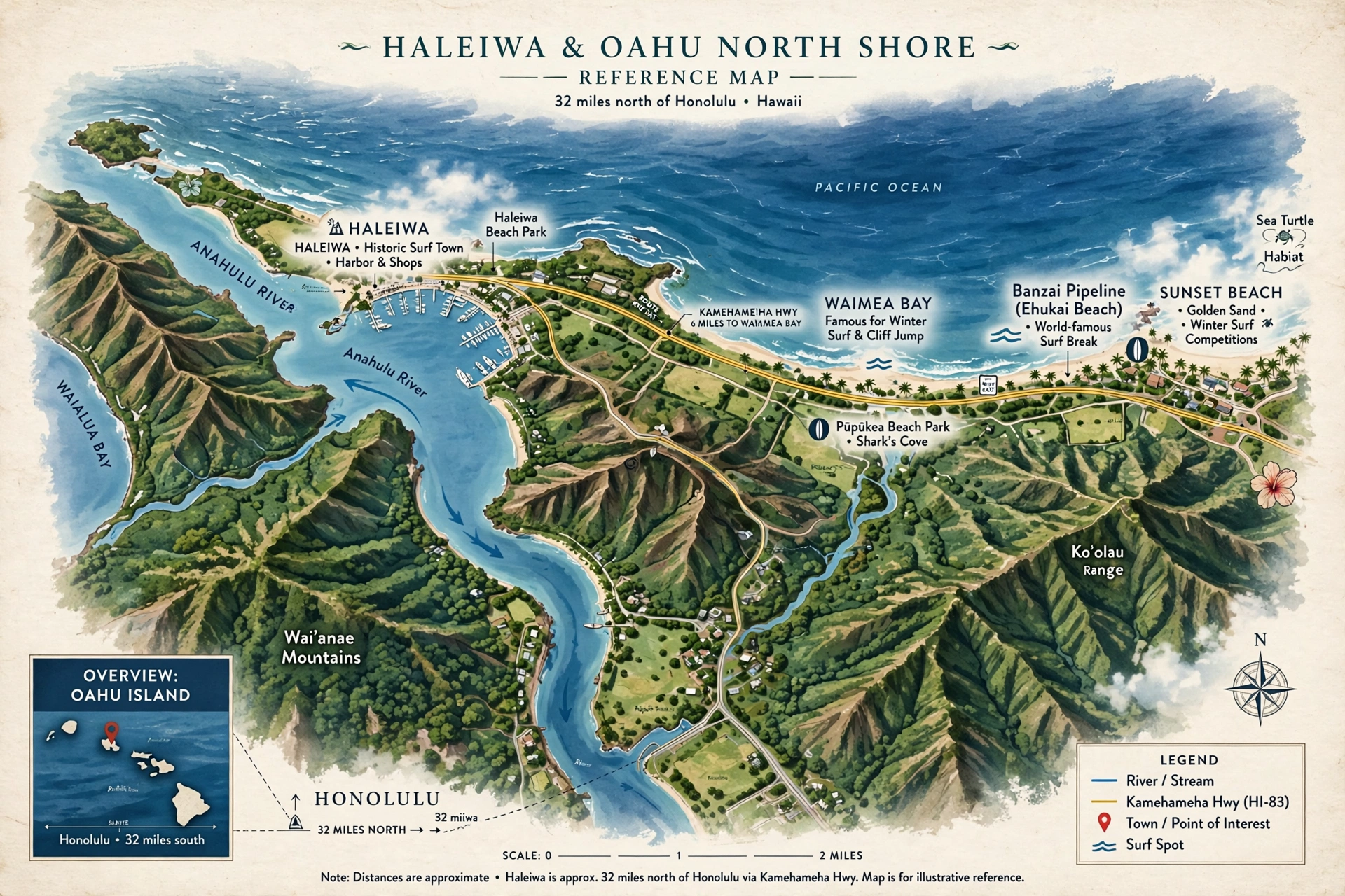
Haleʻiwa sits on the north coast of Oʻahu, the main town of the island’s famous North Shore and the first real town you reach when the central highway drops out of the plateau and meets the sea. On a map of Oʻahu, find it on the northern shoreline, roughly centered between Kaʻena Point to the west and the Banzai Pipeline and Sunset Beach to the east. It is about 32 miles north of Honolulu and about 31 miles from Waikīkī, a drive that usually takes 50 minutes to an hour without traffic and up to 90 minutes when the roads are busy. The drive from Daniel K. Inouye International Airport typically takes 45 minutes to an hour, depending on traffic and the time of day.
The town stands at the mouth of the Anahulu River, the longest watercourse on Oʻahu at 7.1 miles, which drains a roughly 16-square-mile watershed in the northern Koʻolau Range and empties into the eastern end of Waialua Bay right at Haleʻiwa. The river begins about 7 miles northeast of Wahiawā at the meeting of the Kawainui and Kawaiʻiki streams, then runs west and northwest through Kawailoa Gulch to the sea. Archaeological evidence shows Hawaiian villages stood near the river mouth long before European contact, and the valley was repopulated in the early 1800s under Kamehameha I with irrigated taro terraces. The town’s name means “house of the frigate bird,” from hale (house) and ʻiwa (frigate bird), a name given in the late 1800s when businessman Benjamin Dillingham built the Haleʻiwa Hotel along the river and opened it on August 5, 1899. The hotel, reached by Dillingham’s Oʻahu railroad from Honolulu, made the river valley a vacation retreat for Hawaiian royalty and Honolulu society, and the town grew around it as a sugar-plantation and trade center in the early 1900s.
Geographically, Haleʻiwa occupies a narrow coastal strip between Waialua Bay to the north and the agricultural lands of Waialua to the south. The Census-designated place covers about 3 square miles, nearly a quarter of it water. To the west the coast curves toward the rugged, undeveloped shoreline of Kaʻena Point. To the east the coast straightens into the famous “7-mile miracle” stretch of North Shore surf breaks that runs from Haleʻiwa toward Sunset Beach and beyond. The town itself is compact enough to read on a map at a glance: one main highway, one river crossing, one harbor, and two beach parks framing the bay.
The Town on the Map
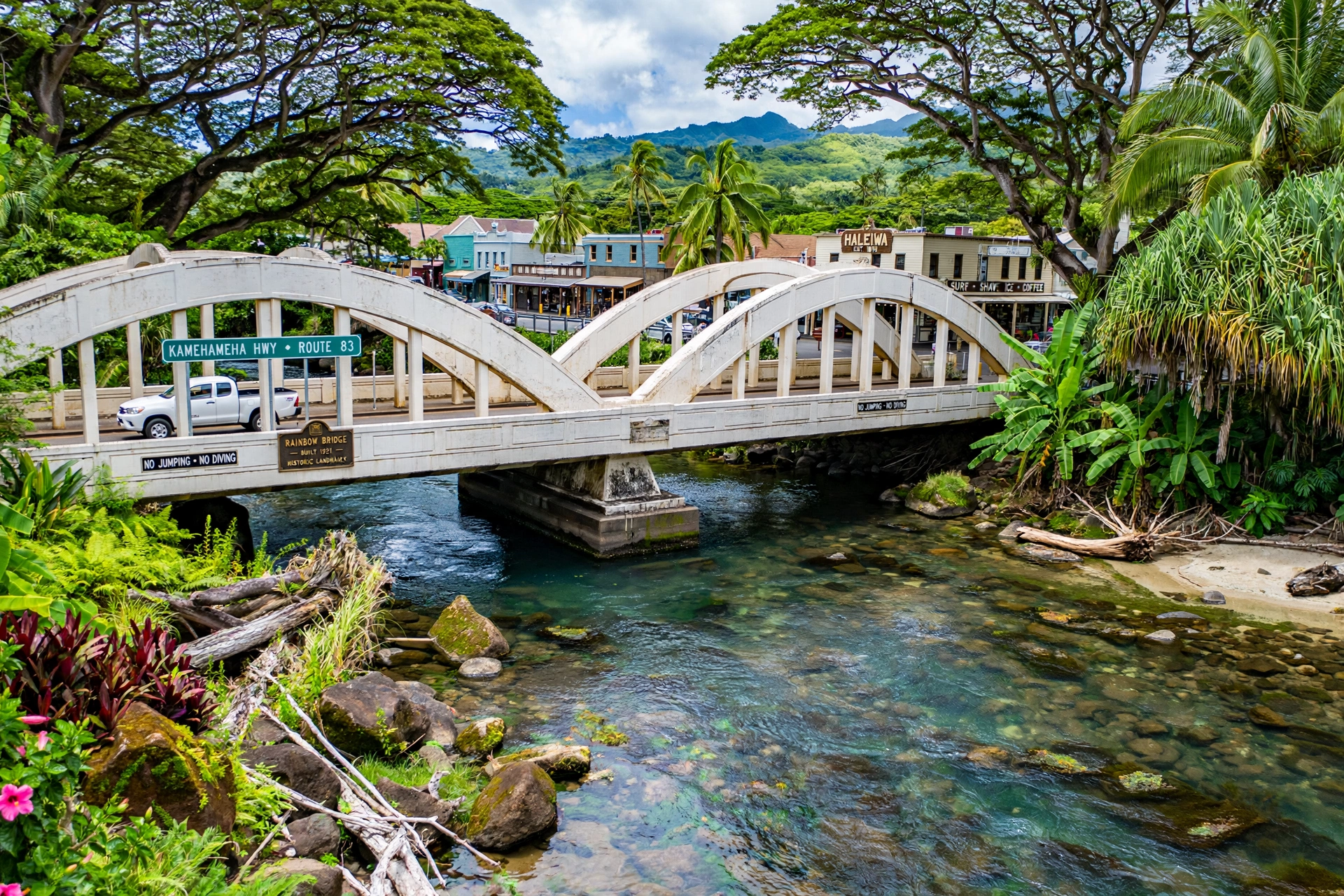
On the map, Haleʻiwa reads as a linear town stretched along Kamehameha Highway where the road bends around the bay. The historic core sits just south of the Anahulu River, with the town’s famous “Rainbow Bridge,” the twin-arched Kamehameha Highway bridge, marking the northern entrance to old Haleʻiwa Town. The bridge carries the highway across the Anahulu River and is one of the town’s most photographed landmarks. From the bridge you can see paddlers on the river below, a quiet counterpoint to the surf town bustle a few blocks away.
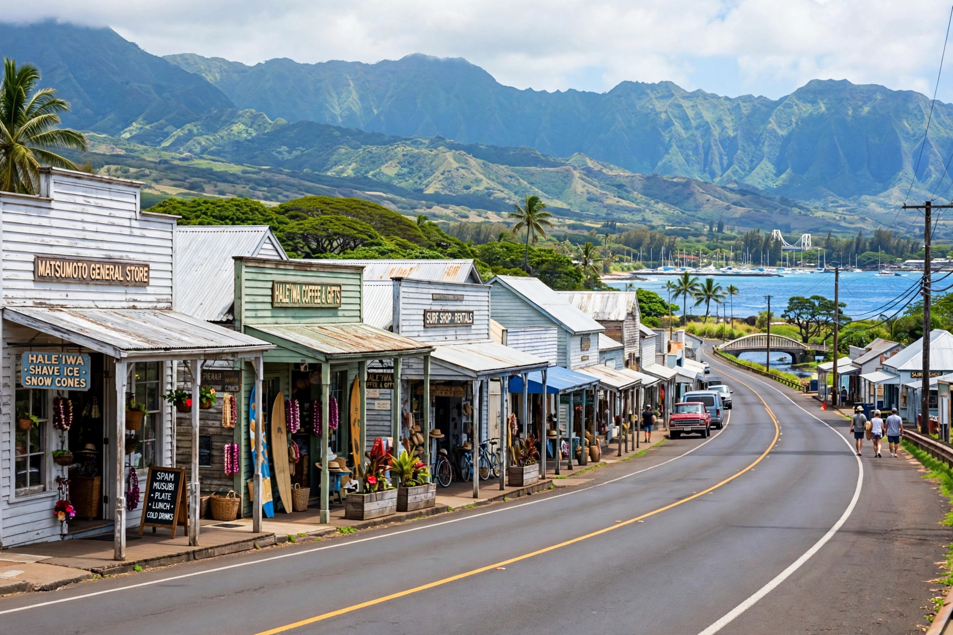
The old town’s storefronts cluster along Kamehameha Highway in a designated Historic, Cultural, and Scenic District, which keeps the plantation-era look intact with low wooden buildings, period facades, and small galleries and eateries. Walking the district with the map in hand, visitors can match the present streetscape to the town’s layered past: the missionary-era church, the railroad-era hotel site, the plantation-era commercial blocks, and the surf-era shops, all standing within a few blocks of the river that made the settlement possible in the first place. The Liliuokalani Protestant Church, founded in 1832 by missionaries John and Ursula Emerson, stands on a grassy plot along the highway with its historic cemetery and lava-rock walls, a quiet anchor among the shops. Queen Liliʻuokalani herself worshiped there when she visited her country home on the banks of the Anahulu River.
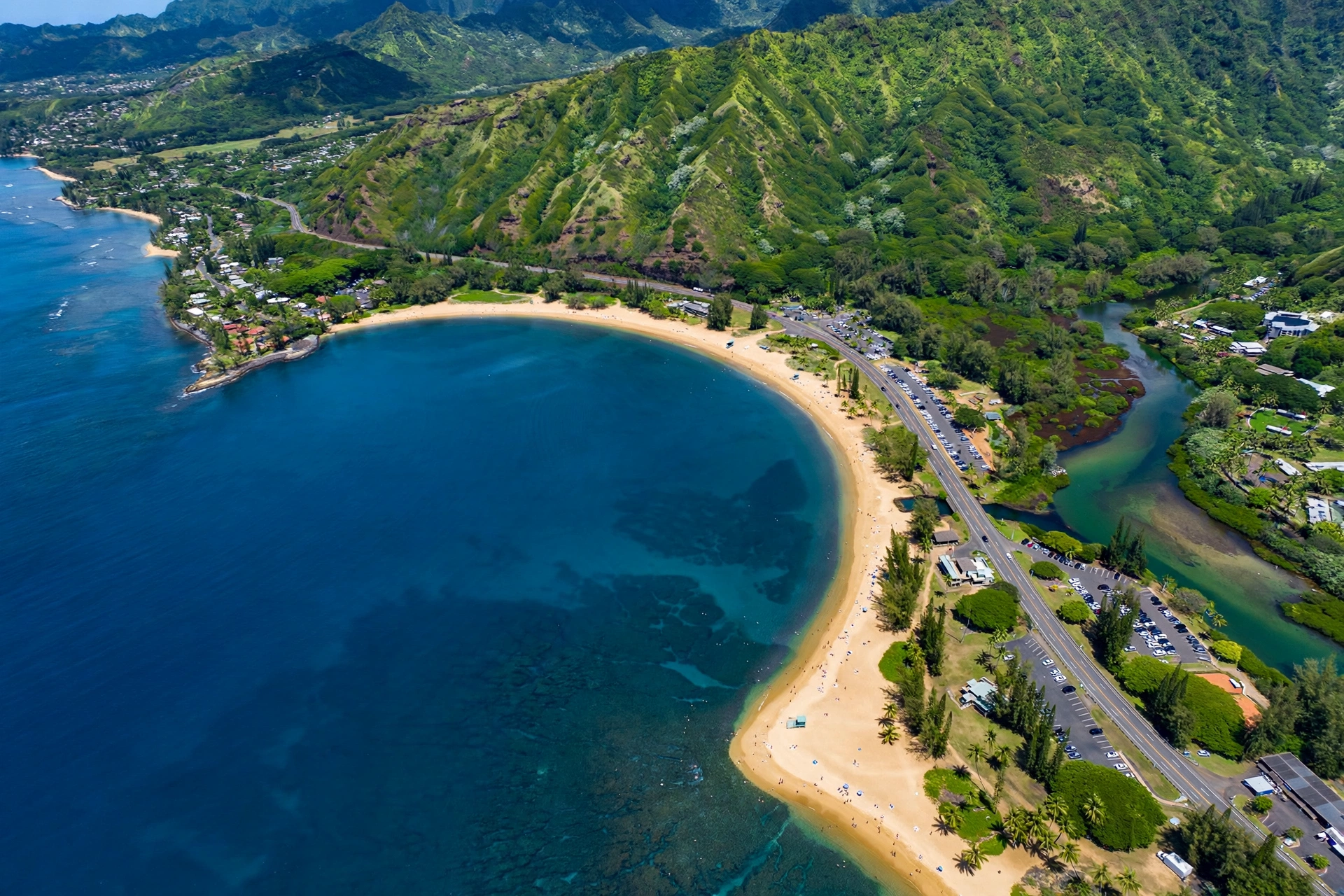
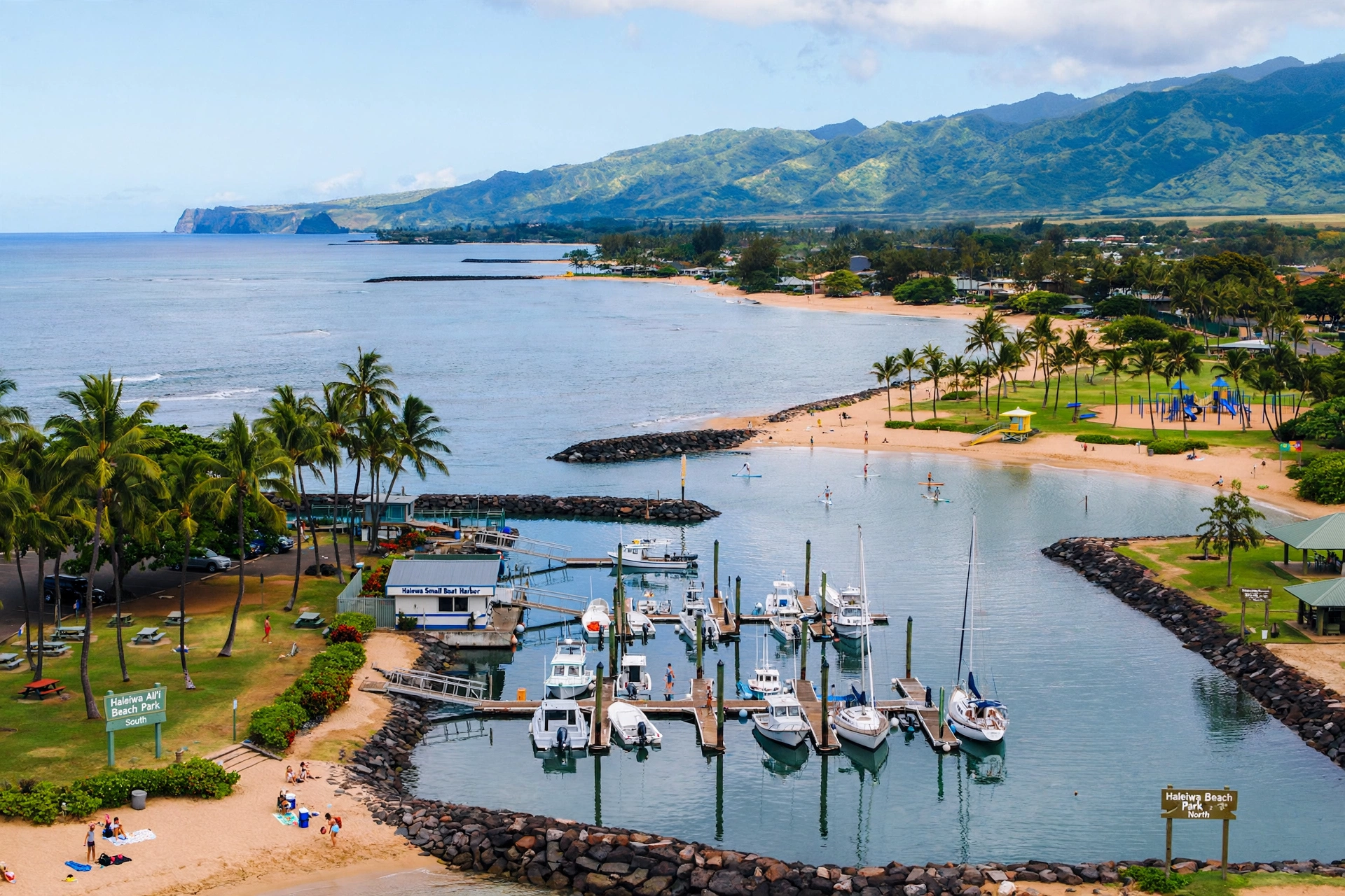
At the northern edge of town, Waialua Bay holds the small boat harbor, with Haleʻiwa Beach Park to the north and Haleʻiwa Aliʻi Beach Park to the south. These two beach parks frame the harbor and give the town its local beach scene, distinct from the big-name surf breaks farther east. Haleʻiwa Beach Park offers a relatively protected swimming area with views back toward Kaʻena Point, while Haleʻiwa Aliʻi Beach Park is the better-known surf spot of the two, with winter waves that draw experienced surfers.
South of the town center, the map shows the Anahulu valley stretching inland toward the Koʻolau Range, with farmland and the rural community of Waialua beyond. The town’s ZIP code, 96712, covers Haleʻiwa plus neighboring Kawailoa. The town never grew into a city; it stayed small by design and by district protection, which is why it still reads on the map as a compact coastal village rather than an urban sprawl. Even the harbor stayed modest: a small boat basin serving local fishers and ocean tours, flanked by the two beach parks, rather than a commercial port. On a nautical chart the bay shows the reef structure that shapes the town’s ocean side, with the protected water near the harbor giving way to open surf as the coast runs east toward the famous breaks.
Key Roads: Kamehameha Highway and Beyond
Kamehameha Highway, State Route 83, is the spine of Haleʻiwa and of the entire North Shore. On the map it enters town from the east after running along the coast past Waimea Bay, Pipeline, and Sunset Beach, then bends south through Haleʻiwa and continues southwest toward Waialua. Inside town it carries all the through traffic, and in the busy season it is the reason for Haleʻiwa’s famous congestion, since every vehicle traveling the North Shore corridor passes through this one stretch.
At the traffic circle known as Weed Circle, just south of town, Kamehameha Highway becomes State Route 99, which runs eastward up across the Oʻahu central plateau toward Wahiawā and connects to the H-2 freeway back to Honolulu. This is the main inland route and usually the fastest way to reach Honolulu from Haleʻiwa. The Joseph P. Leong Highway, a newer bypass, carries Route 83 around the traffic circle and the town itself, rejoining just north of Haleʻiwa, which helps through traffic skip the town center.
From Weed Circle, several smaller roads head south and southwest into Waialua across Paukauila Stream: Haleʻiwa Road, Kaukonahua Road, and Waialua Beach Road. These are local connectors rather than through routes, useful for reaching the Waialua side and the agricultural interior. The harbor area is reached by short side streets off the highway near the bay, and parking for the beach parks is signed from the highway.
For planning, the key thing the map shows is that Haleʻiwa has exactly one arterial in each direction: Kamehameha Highway along the coast and Route 99/Weed Circle inland. When traffic backs up, which it regularly does on winter weekends and contest days, there is no alternate coastal route. Travelers who check the map before leaving learn the rhythm of the corridor: arrive early, leave before the afternoon rush, and expect the town’s one main street to move slowly at midday.
Nearby on the Map: Waimea Bay, Pipeline, and Sunset Beach
East of Haleʻiwa, the coast unfolds into the most famous surf geography on earth, and the map is the best way to understand how the breaks relate to each other. Heading east on Kamehameha Highway from town, the first major landmark is Waimea Bay, about 4 miles away. The bay is a deep crescent that produces some of the largest rideable waves on the planet in winter, with swells over 15 feet and faces reaching far higher on the biggest days, while summer turns it into a calm swimming and snorkeling beach. Across the highway from the bay, Waimea Valley’s botanical garden and waterfall sit inland, making this one stop with two very different experiences.
Continuing east about 3 more miles brings you to ʻEhukai Beach Park, home of the Banzai Pipeline, the hollow, heavy reef break that defines professional surfing. Pipeline sits just offshore of an ordinary-looking stretch of sand, which surprises first-time visitors who expect the wave to announce itself. The full story of where the break sits and how to see it is covered in our dedicated guide to where Pipeline is in Hawaiʻi, which this page defers to rather than duplicating.
About a mile past Pipeline, Sunset Beach stretches out as the broad, open beach break that hosts the winter’s biggest and most photogenic surf. In summer it calms into a long, swimmable strand. The three spots, Waimea Bay, Pipeline, and Sunset Beach, sit within about 8 miles of each other along one continuous highway, which is why the North Shore works so well as a single driving day: park once per stop, walk the sand, and watch the conditions change from cove to reef to open beach.
To the west of Haleʻiwa, the map shows a different kind of coastline. The shore curves toward Kaʻena Point, Oʻahu’s westernmost tip, with fewer towns, narrower roads, and increasingly wild scenery. Mokulēʻia and the Dillingham Airfield area sit along this stretch, and the road eventually narrows toward the point itself, where vehicle access ends and a coastal trail continues. Most Haleʻiwa visitors head east for the famous breaks, but the western road rewards travelers who want the island’s quieter edge. The contrast is visible on any terrain map: to the east, a developed coastal plain with beaches and parks; to the west, rising ground and empty shoreline running out to the point.
Haleʻiwa’s Place in North Shore Geography
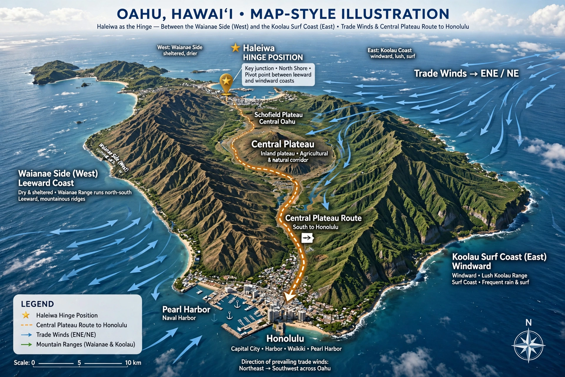
On an island-wide map, Haleʻiwa is the hinge between two different Oʻahus. West of town the coast belongs to the Waiʻanae Range side: drier, less developed, with the road narrowing as it runs toward Kaʻena Point and the military and agricultural lands beyond. East of town the coast belongs to the Koʻolau side: wetter, greener, lined with the reef breaks and bays that made the North Shore famous. Haleʻiwa sits exactly at the joint, where the Anahulu River valley opens between the two mountain systems and the shoreline changes character.
This hinge position explains why the town became the North Shore’s service center. Plantation-era roads and the railroad converged here because the valley offered the only easy passage between the central plateau and the north coast. The harbor, though small, is the only protected boat basin on this stretch of coast, which is why the two beach parks grew up around it. Everything the North Shore needs, from surf shops to groceries to a post office, concentrated in the one town with river water, flat land, and road connections in every direction.
The map also shows why Haleʻiwa weather differs from Honolulu’s. The town faces north into the trade winds, so it catches the weather systems that pass over the city. Winter brings the big northwest swells that light up the surf breaks, and it also brings more rain than the south shore sees. Summer reverses the pattern: the swells fade, the beaches calm, and the town settles into a quieter rhythm. Travelers planning around surf or swimming do well to read the seasonal geography, not just the road map, since the same beach can be a world-class surf arena in January and a placid swimming cove in July.
Finally, the map reveals Haleʻiwa’s relationship to the rest of the island. Wahiawā and the central plateau lie inland to the southeast, connected by Route 99. The Windward Coast runs east past the surf breaks toward Kahuku and Turtle Bay. Honolulu lies south over the plateau via the H-2. Haleʻiwa is not remote; it is simply at the far end of every route, which gives it the feeling of a destination even though it is barely an hour from the city. That combination, close on the map and far in feeling, is the essence of the town.
Navigating Haleʻiwa Day to Day
A rental car is the practical way to navigate Haleʻiwa and the North Shore, because the sights spread along miles of highway and the town’s own parking is limited. The town center has small lots and street parking that fill early on weekends; the beach parks have their own lots that also fill, especially at Waimea Bay on big-swell days. Arriving before mid-morning is the simplest parking strategy anywhere in the corridor.
TheBus serves Haleʻiwa on routes that run Kamehameha Highway from Honolulu and Wahiawā, which makes a car-free day trip possible but slow, with travel times of two hours or more from Waikīkī. Within town, everything in the historic core is walkable: the shops, the church, the Rainbow Bridge viewpoint, and the harbor are all within a short stroll of each other. The beach parks at the harbor are walkable from town too, while Waimea Bay, Pipeline, and Sunset Beach require a vehicle or a bus ride east.
Traffic is the main navigation factor. Kamehameha Highway through Haleʻiwa is a two-lane road carrying the entire North Shore, so winter weekends, surf contest days, and the afternoon return rush all slow it down. The inland route via Weed Circle and Route 99 to the H-2 is usually faster for reaching Honolulu, while the coastal highway is the scenic choice. Checking surf and event schedules before choosing a day helps, since contest days bring road closures and crowds to specific beaches.
For a simple day plan, the map suggests itself: start in Haleʻiwa town for the historic core and the river, drive east along the coast stopping at Waimea Bay, Pipeline, and Sunset Beach in order, then return by the same road or loop back inland through Wahiawā. The whole corridor from Haleʻiwa to Sunset Beach is under 10 miles, so the driving is short and the stops are the point. Travelers with two days can add the western road toward Kaʻena Point on the second day, when the morning light favors that side of the island and the crowds thin out past Mokulēʻia.
One more map-reading tip: the mile markers and small green highway signs along Kamehameha Highway are the most reliable way to find the beach accesses, since many of the surf breaks sit between named parks and the parking pullouts are easy to miss at driving speed. Noting the access points on a map before leaving Haleʻiwa saves the slow crawl of circling back on a two-lane road. The town’s visitor information, posted maps, and the lifeguard stations at the beach parks all use the same landmark system, so a few minutes of orientation in town pays off for the whole day.
Frequently Asked Questions
Where is Haleʻiwa on the map?
Haleʻiwa is on the north coast of Oʻahu, the main town of the island’s North Shore, at the mouth of the Anahulu River on Waialua Bay. It sits about 32 miles north of Honolulu and roughly 31 miles from Waikīkī.
Is Haleʻiwa a city or a town?
Haleʻiwa is a small town, officially a Census-designated place of about 3 square miles. Its historic core is protected as a Historic, Cultural, and Scenic District, which has kept it compact and low-rise.
How far is Haleʻiwa from Honolulu and Waikīkī?
The drive is about 31 to 34 miles depending on the route, typically 50 minutes to an hour without traffic and up to 90 minutes in traffic. From the airport it usually takes 45 minutes to an hour.
What is the Rainbow Bridge in Haleʻiwa?
The Rainbow Bridge is the local name for the Kamehameha Highway bridge over the Anahulu River, named for its twin arches. It marks the northern entrance to old Haleʻiwa Town and is a popular viewpoint over the river.
How far is Waimea Bay from Haleʻiwa?
Waimea Bay is about 4 miles east of Haleʻiwa on Kamehameha Highway, a drive of roughly 10 minutes without traffic. Pipeline is about 7 to 8 miles east, and Sunset Beach about 5 to 6 miles east.
What is the main road through Haleʻiwa?
Kamehameha Highway (Route 83) is the main road, running through the town center and along the North Shore coast. At Weed Circle south of town it becomes Route 99, the inland route toward Wahiawā and the H-2 freeway.
Can you swim at Haleʻiwa’s beaches?
Haleʻiwa Beach Park has a relatively protected swimming area, and Waimea Bay is calm in summer. In winter, North Shore surf is powerful and dangerous; lifeguarded beaches post warnings, and visitors should check conditions before entering the water.
Do I need a car to visit Haleʻiwa?
A rental car is strongly recommended. The town core is walkable and TheBus reaches Haleʻiwa, but the North Shore sights spread along miles of highway, parking fills early, and bus trips from Honolulu take two hours or more.
Related Hawaii Guides
- Where Is Pipeline in Hawaiʻi: the full guide to the Banzai Pipeline’s location and viewing
- Oʻahu Travel Guide: the complete island overview
- Where Is Oʻahu Located in Hawaiʻi: the island’s position in the chain
- Oʻahu Beaches: the island’s best beaches by coast
- Waikīkī, Hawaiʻi: the south shore’s famous neighborhood
- Hawaiʻi Map: the statewide map overview
Reading Haleʻiwa on the Map
Haleʻiwa rewards travelers who read the map before they drive it. The town’s position at the mouth of the Anahulu River, its single highway running the North Shore corridor, and the tight cluster of Waimea Bay, Pipeline, and Sunset Beach just to the east all become clear on paper before they are clear through the windshield. With the layout understood, the town stops being a traffic bottleneck and becomes what it has always been: the gateway to the North Shore, a small historic town sitting exactly where the island’s most famous coastline begins.