
Lānaʻi Hikes
Lānaʻi is the smallest inhabited Hawaiian island, and its hiking scene matches its character: compact, uncrowded, and deeply rewarding for walkers who arrive prepared. There is no sprawling trail network here and no shuttle buses to trailheads. What you get instead is a short list of genuinely memorable walks, from a misty ridge trail through Cook pines to a red rock desert that feels like another planet. This guide covers every worthwhile hike on the island, plus the access rules, safety realities, and planning details that make or break a Lānaʻi hiking trip.

Lānaʻi Hiking: An Overview
Hiking on Lānaʻi is unlike hiking anywhere else in Hawaiʻi. The island measures roughly 18 miles by 13 miles, with a single eroded shield volcano rising to Lānaʻihale at 3,366 feet. There are no state parks with maintained trail systems, no county beach parks with trailheads, and no visitor centers selling trail maps. The trails that exist are a mix of old ranch roads, ridgeline tracks, coastal footpaths, and short interpretive walks, and most of them see only a handful of hikers on any given day.
The island’s hiking divides naturally into three zones. The cool central highlands around Lānaʻi City hold the island’s best ridge hiking, including the famous Munro Trail, where morning fog drifts through Cook pines planted more than a century ago. The calm south coast offers easy coastal walking at Hulopoʻe Beach, the island’s only reliably swimmable beach and a marine life conservation district. The wild north and west sides hold the island’s most otherworldly walks, including the rust red boulder field of Keahiakawelo, known as the Garden of the Gods.
Self reliance is the defining feature of Lānaʻi hiking. There are no trailhead water fountains, no restrooms on most trails, and no rangers patrolling. Cell service disappears within minutes of leaving Lānaʻi City or Mānele. The island has one small hospital in Lānaʻi City, and serious emergencies require air transport to Oʻahu or Maui. None of this should scare you off, but it means every hike here deserves real preparation, the kind of preparation that island visitors sometimes skip on more developed islands.
The other defining feature is the weather window. Lānaʻi City sits at about 1,645 feet, and the Munro Trail ridge runs higher still, so mornings frequently bring cool mist and low clouds that burn off by midday. Down at the coasts, the south shore stays warm and dry almost year round, while the north shore takes the brunt of winter swells and trade winds. A single day can include a chilly, foggy ridge walk and a sunny beach stroll, so dressing in layers is not optional.
Finally, understand that Lānaʻi hiking is quiet hiking. You will share these trails with axis deer, mouflon sheep in the high country, and very few people. For many visitors, that solitude is the whole point. Treat it with the respect it deserves: pack out everything, stay on established routes, and keep noise down, especially in the early morning when the island’s birds are most active.
The Best Hikes on Lānaʻi
Lānaʻi does not have dozens of trails, and that is fine. The six walks below are the ones worth your time, ordered roughly from most to least demanding. Each is described with distance, difficulty, access, and what makes it special.
The Munro Trail
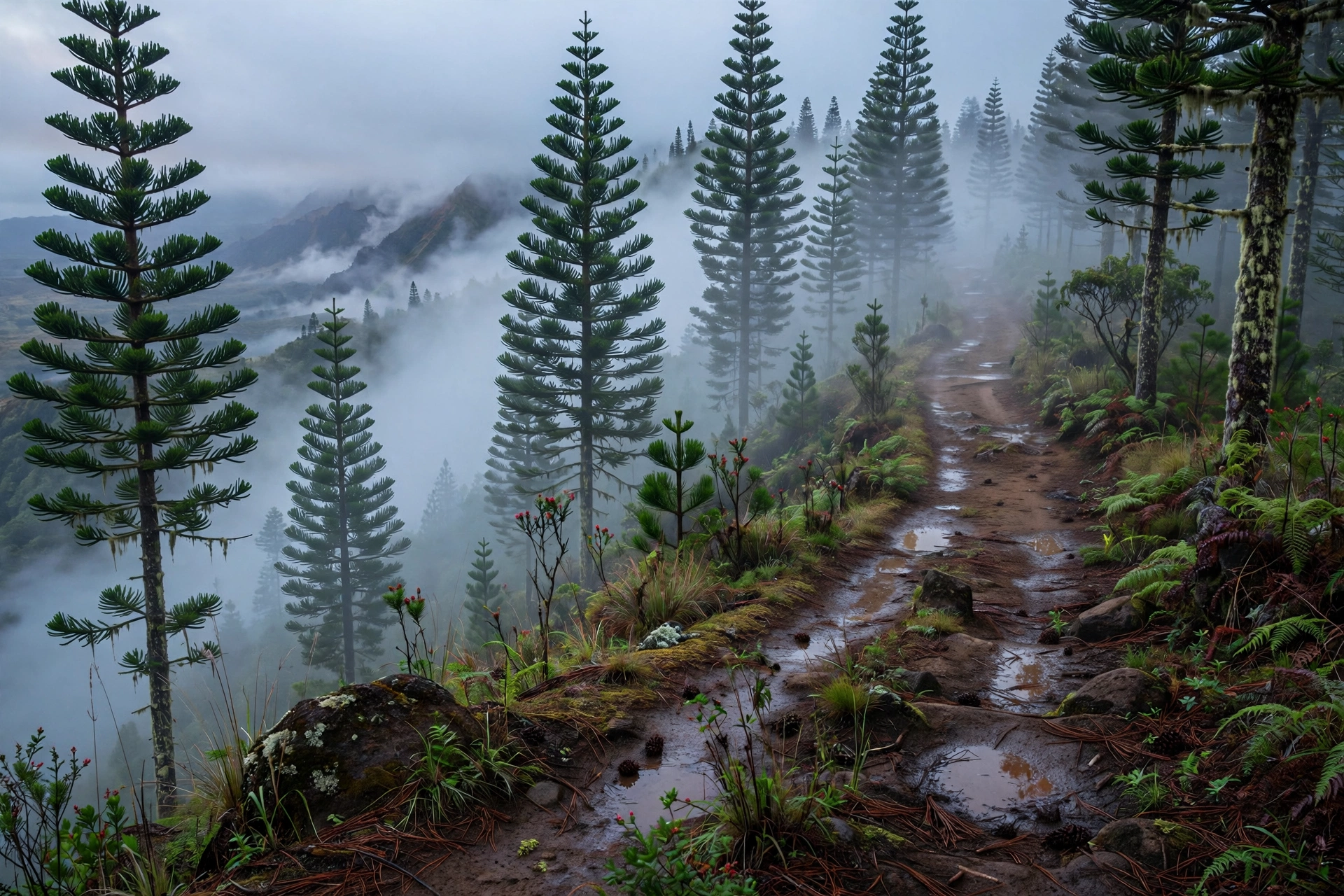
The Munro Trail is the island’s signature hike and one of the most atmospheric walks in all of Hawaiʻi. This roughly 13 mile ridgeline route runs along the spine of Lānaʻihale, the island’s summit ridge, through towering Cook pines that George Munro planted in the early 1900s to capture moisture from the clouds. On a misty morning, the trail feels like a temperate rainforest that wandered into the tropics by mistake.
The full route is long, but few people hike it end to end. The most popular section starts near the Lānaʻi City end and climbs through the pines to viewpoints overlooking the ʻAuʻau Channel and Maui. On clear mornings, the views stretch from Molokaʻi to the West Maui Mountains, and on very clear days you can see all the way to the Big Island. The catch is the dawn window: the ridge clouds over by late morning most days, so the classic Munro experience starts early, often before 7 a.m.
Difficulty is moderate to challenging depending on how far you go. The trail surface is a mix of dirt track, pine needle duff, and occasional muddy sections after rain. There is meaningful elevation gain along the ridge, and the full 13 miles is a serious day. Most day hikers do an out and back of 2 to 5 miles, which captures the best scenery without the full commitment. The trailhead is reached by dirt road, and high clearance is helpful though not always required in dry conditions.
Bring a jacket even on warm days. The ridge sits above 2,000 feet for much of its length, and the combination of elevation, wind, and mist can make 65 degrees feel genuinely cold. This is the one Lānaʻi hike where underdressing is the most common mistake.
Koloiki Ridge Trail
The Koloiki Ridge Trail is the Munro Trail’s shorter, friendlier sibling. This out and back walk of roughly 5 miles round trip follows a pine lined ridge with several excellent viewpoints over the north shore and the ʻAuʻau Channel. It shares the Munro Trail’s cool, misty character but requires less time and less commitment, making it the best choice for hikers who want the ridge experience without a full day on the trail.
The trail passes through native and introduced forest, with interpretive interest in the watershed the Cook pines protect. Birders should bring binoculars: the high forest holds native birds that are absent from the lowlands, and the morning chorus here is one of the island’s underrated pleasures. As with the Munro Trail, start early for the best views before the clouds settle in.
Hulopoʻe Coastal Walk
At the opposite end of the difficulty spectrum, the coastal walk at Hulopoʻe Beach is the island’s easiest and most accessible hike. Starting from the white sand of Hulopoʻe, a shoreline trail leads to tide pools, lava rock formations, and Puʻupehe, known as Sweetheart Rock, the sea stack tied to one of Hawaiʻi’s best known legends.
This is a walk rather than a hike, suitable for all fitness levels, and it pairs naturally with a beach day. The trail surface is uneven lava in places, so wear real footwear rather than flip flops. Note that Puʻupehe is culturally significant and the surrounding waters are part of the Mānele Hulopoʻe Marine Life Conservation District, which means fishing and collecting are restricted. Admire, photograph, and leave everything exactly as you found it. Do not attempt to climb the rock.
Combine this walk with snorkeling at Hulopoʻe for the island’s best half day. Morning offers the calmest water and the best light on Sweetheart Rock.

Keahiakawelo Walk (Garden of the Gods)
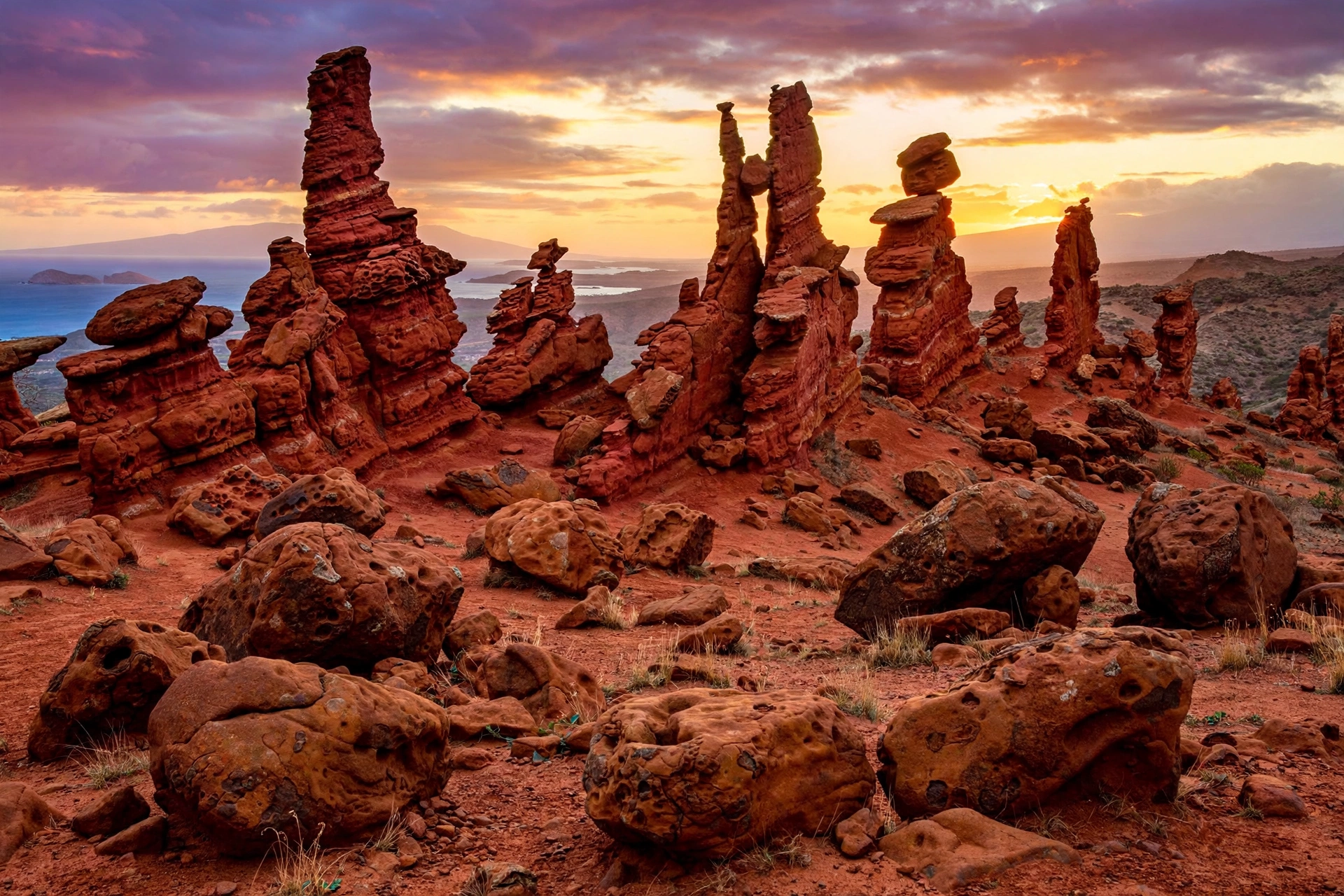
Keahiakawelo, called the Garden of the Gods, is the strangest landscape on Lānaʻi and one of the strangest in Hawaiʻi. A field of rust red and orange boulders and rock towers sprawls across a dry plateau on the island’s north side, the product of centuries of erosion. Walking among the formations at sunset, when the rocks glow, is unforgettable.
The walk itself is easy: a short loop and viewpoint area rather than a real trail, with most visitors spending 30 to 60 minutes wandering the formations. The challenge is getting there. Keahiakawelo is reached by the Keahiakawelo Access Road, a rough dirt track that requires four wheel drive, and the drive takes 45 minutes or more from Lānaʻi City. The road is deeply rutted in places and should not be attempted in a standard rental car or after rain.
Two cultural notes matter here. First, do not stack rocks or build cairns. This is a wahi pana, a storied and sacred place, and rearranging the stones is disrespectful. Second, stay on the established walking area. The surrounding land is fragile desert pavement that takes decades to recover from footprints and tire tracks.
Lānaʻihale Summit
Lānaʻihale, at 3,366 feet, is the highest point on Lānaʻi and the summit of the island’s ancient volcano. The summit is reached via the Munro Trail ridge, and reaching the top is a goal for peak baggers rather than a standalone hike. There is no maintained summit trail separate from the ridge route, and the summit area itself is forested with limited views.
The value of the summit push is the journey rather than the destination: the full Munro Trail traverse is the island’s great ridge walk, and the summit is its natural high point. Only attempt it with ample water, a full day, and a clear plan for the return, whether that means retracing your steps or arranging a pickup.
North Shore Viewpoints
Lānaʻi’s north shore has no maintained coastal hiking trail, and the shoreline itself is wild, exposed, and often dangerous. What it does have are spectacular viewpoints reached by 4WD roads, most notably the overlooks above Kaiolohia, known as Shipwreck Beach, where the rusting hull of the YOGN-42 sits offshore.
Short walks from the parking areas lead to cliff edge viewpoints with sweeping views of the windswept coast and, on clear days, Molokaʻi across the channel. Stay well back from cliff edges, which are undercut and unstable, and do not attempt to descend to the beach at unimproved spots. The north shore surf is powerful and the shoreline is unguarded. Treat every north shore viewpoint as a viewpoint, not a trailhead to the water.
Trail distances at a glance: Munro Trail full route ~13 miles (most hikers do 2 to 5 mile sections) | Koloiki Ridge ~5 miles round trip | Hulopoʻe coastal walk ~1 mile | Keahiakawelo loop under 1 mile | Lānaʻihale summit via Munro Trail, full day | North shore viewpoints, short walks from parking areas. Distances are approximate and conditions vary.
Trail Access and Permissions
Trail access on Lānaʻi is refreshingly simple compared to islands with complex permit systems, but it has its own quirks. There are no hiking permits required for any of the trails in this guide, and no trailhead fees. The main access question is not permission but transportation: several trailheads are reached only by rough dirt roads that require four wheel drive.
The Munro Trail and Koloiki Ridge trailheads are accessed from the Lānaʻi City side via dirt roads. In dry conditions, a standard high clearance vehicle can manage, but after rain these roads turn slick and rutted. Keahiakawelo is the strictest case: the access road genuinely requires four wheel drive, and rental agreements for standard cars explicitly exclude it. The island’s small 4WD rental fleet books out early, so reserve well in advance if Keahiakawelo is on your list.
Kānepuʻu Preserve, the Nature Conservancy’s 590 acre native dry forest remnant, is a special case. It is the last intact example of its forest type in Hawaiʻi, and access is by guided tour only. If native plants and dryland forest ecology interest you, the guided visit is worth arranging, but do not show up expecting to wander in on your own.
Private land is the other access reality. Much of Lānaʻi is privately owned, and the island’s small community is protective of its quiet. Stay on established public routes, respect every gate and sign, and never cross private land to reach a viewpoint or shoreline. When in doubt, ask locally: the staff at the Lānaʻi Culture and Heritage Center in Lānaʻi City are excellent sources of current access information.

Hiking Safety on Lānaʻi
Lānaʻi’s trails are not technically extreme, but the island’s remoteness raises the stakes of every mistake. Read this section before you hike, not after something goes wrong.
Water is the number one issue. There is no potable water at any trailhead on the island and none along any trail. The ridge trails are cool enough to lull hikers into underestimating their needs, but the elevation gain is real and the sun at midday is intense. Carry more water than you think you need: a liter per person for short walks, and three or more liters for the Munro Trail. There is nowhere to refill.
Heat and sun hit the lowland walks hard. The Hulopoʻe coastal walk, Keahiakawelo, and the north shore viewpoints offer little to no shade. Keahiakawelo in particular is a furnace by midday, which is why late afternoon is the preferred visiting time. Wear a hat, use reef safe sunscreen, and schedule exposed walks for morning or late afternoon.
Remoteness changes the math. Cell service is unreliable or absent on the ridge, at Keahiakawelo, and along the north shore. Tell someone your plans and expected return time. Hike with a buddy on the longer routes. The island’s medical facilities are limited, and a twisted ankle on the Munro Trail is a much bigger problem than the same injury on a busy Oʻahu trail. Carry a basic first aid kit and know that help may be hours away.
Hunting areas overlap some trail corridors. Axis deer and mouflon sheep hunting occurs in designated areas, and hunters share the landscape. Wearing bright colors during hunting seasons is wise, and staying on established trails keeps you where you are expected to be. If you hear hunting activity nearby, make your presence known calmly and give the area space.
Cliff edges and the ocean demand respect. The north shore cliffs are sheer and the rock is unstable near edges. Never approach a cliff edge for a photograph. The ocean at Shipwreck Beach and the north shore generally is rough, unguarded, and indifferent to your swimming ability. These are viewpoints, full stop.
Weather shifts fast on the ridge. A clear morning on the Munro Trail can turn foggy and drizzly by 10 a.m., dropping visibility to a few dozen feet. The trail is generally easy to follow, but fog plus unfamiliar terrain is a bad combination. Start early, carry a layer, and turn back if conditions deteriorate rather than pushing deeper into the mist.
Emergency basics: Call 911 for emergencies. Response times on Lānaʻi can be long, especially on dirt roads and remote trails. The Lānaʻi Community Hospital in Lānaʻi City handles basic care; serious cases are airlifted to Maui or Oʻahu. Prevention, preparation, and conservative decisions are your real safety net on this island.
What to Bring
Packing for Lānaʻi hiking is about covering two climates in one day and carrying everything you need, because there is nothing to buy or borrow on the trail. Use this checklist:
- Water: more than you think. One liter minimum for short walks, three plus liters for ridge hikes. There are no refills anywhere.
- Layers: a light rain shell or warm layer for the ridge, even on sunny days. Lānaʻi City mornings can start in the 60s.
- Sun protection: hat, sunglasses, and reef safe sunscreen. Hawaiʻi law restricts sunscreens containing oxybenzone and octinoxate.
- Footwear: trail shoes or hiking shoes with real grip. The Hulopoʻe lava is sharp, the Munro Trail can be muddy, and flip flops are inadequate everywhere.
- Food: snacks or a full lunch for longer hikes. There are no trail concessions and limited dining outside Lānaʻi City.
- Navigation: download offline maps before you leave your lodging. Do not count on cell service or trail signage.
- First aid: a compact kit with blister care, antiseptic, and any personal medications.
- Light: a headlamp or flashlight, even for day hikes. A delayed return on the ridge without light is a genuine emergency.
- Cash and fuel awareness: not trail gear, but essential context. There is one gas station on the island, in Lānaʻi City. Top up before driving to remote trailheads.
Best Time to Hike
Lānaʻi hiking is a year round activity, but the experience shifts meaningfully with the seasons. The dry season, roughly April through October, brings the most reliable conditions: clearer ridge mornings, calmer south shore water, and dry dirt roads to Keahiakawelo and the north shore. This is the best window for the full range of hikes, and it is when the island’s small visitor infrastructure is at its most functional.
The wet season, roughly November through March, has its own appeal. Winter is whale season, and the channel views from the Munro Trail and north shore viewpoints can include breaching humpbacks offshore. Rain brings out the island’s greenest colors and occasional waterfalls in the high country. The tradeoffs are real, though: muddier ridge trails, cloudier viewpoints, rougher north shore conditions, and dirt roads that can become impassable after heavy rain.
Within any season, timing your day matters as much as timing your trip. Start ridge hikes early, ideally on the trail by 7 a.m., to catch the clear window before the clouds build. Save exposed lowland walks like Keahiakawelo for late afternoon, when the light is golden and the heat has eased. The Hulopoʻe coastal walk is pleasant any time but best in the morning before the beach fills.
Frequently Asked Questions
What is the best hike on Lānaʻi?
The Munro Trail is the island’s signature hike, a misty ridgeline walk through Cook pines with channel views to Maui. For a shorter version of the same experience, the Koloiki Ridge Trail delivers excellent views in about 5 miles round trip. For something completely different, the walk among the red rock towers of Keahiakawelo is unforgettable.
Do I need a permit to hike on Lānaʻi?
No permits are required for the trails in this guide. The one exception is Kānepuʻu Preserve, the Nature Conservancy’s native forest remnant, which is accessible by guided tour only. The real access constraint on Lānaʻi is transportation: several trailheads require four wheel drive.
Can I hike the full Munro Trail?
The full route is about 13 miles along the ridge and is a serious full day undertaking. Most hikers do shorter out and back sections from the Lānaʻi City side, which capture the best scenery. If you attempt the full traverse, carry ample water, start at dawn, and arrange your return transportation in advance.
Is Keahiakawelo (Garden of the Gods) worth the drive?
Yes, with the right expectations. The landscape is genuinely otherworldly, especially at sunset. But the access road requires four wheel drive and takes 45 minutes or more each way, and the walk itself is short. It is a half day commitment for an hour of wandering. Visitors who love stark desert landscapes consider it a highlight; those expecting a big hiking payoff may prefer the ridge trails.
Are there dangerous animals on Lānaʻi trails?
No. Hawaiʻi has no snakes, no large predators, and no venomous land animals. The wildlife you may meet includes axis deer, mouflon sheep, and birds. The real hazards are environmental: heat, dehydration, cliff edges, and remoteness. Insects are a minor nuisance at most.
Can I hike to Shipwreck Beach?
The north shore viewpoints above Kaiolohia are reached by 4WD road, with short walks to overlooks. There is no maintained trail down to the beach itself, and the shoreline is wild and unguarded with powerful surf. Enjoy the views from the overlooks and do not attempt unimproved descents.
What should I wear hiking on Lānaʻi?
Layers. The ridge can be 15 to 20 degrees cooler than the beach, and morning fog adds wind chill. A moisture wicking base, a warm mid layer, and a light shell cover the full range. Sturdy closed toe footwear is essential everywhere; the lava rock at Hulopoʻe and the muddy sections of the Munro Trail both punish inadequate shoes.
Is Lānaʻi good for beginner hikers?
Yes, with guidance. The Hulopoʻe coastal walk and the Keahiakawelo stroll are easy and suitable for all fitness levels. Koloiki Ridge is a moderate introduction to ridge hiking. Beginners should skip the full Munro Trail and any 4WD dependent trailhead unless they are comfortable with remote dirt road driving. The key beginner skill on Lānaʻi is preparation, not fitness.
Related Guides
- Lānaʻi Travel Guide: the complete island overview, including getting there and where to stay
- Lānaʻi Map: regions, roads, and drive times across the island
- Hawaiʻi Hikes: the statewide hiking hub with island by island trail guides
- Maui Hikes: trails on neighboring Maui, an easy ferry ride away
- Molokaʻi Hikes: rugged valley and ridge hiking on the Friendly Isle
- Hawaiʻi Map: the full island chain at a glance
A Final Note
Lānaʻi rewards hikers who slow down. This is not an island for ticking off trail miles; it is an island for standing in morning fog among century old pines, for watching the light change on red rocks that have waited millions of years for an audience, and for walking a quiet shoreline where the loudest sound is the water. Come prepared, start early, respect the land and the community that cares for it, and Lānaʻi will give you some of the most peaceful miles you will ever walk in Hawaiʻi.