
Kīhei Hawaiʻi Map
Kīhei on the Map: Overview
Kīhei sits on the southwest shore of Maui, on the leeward side of Haleakalā. The town stretches for about six miles along the coast, following the shoreline from Māʻalaea in the north to the Wailea border in the south. On a map of Maui, look for the long, nearly straight coastline on the island’s sun-drenched southwestern edge. That is Kīhei.
Geographically, Kīhei occupies a narrow coastal band between the ocean and the lower slopes of Haleakalā. The town is wide at only a mile or two in most places, because the land rises quickly inland toward the volcano’s flanks. This gives Kīhei a simple, linear layout that is easy to read on a map: one main coastal road, one inland highway running parallel, and a beach chain facing the ʻAlalākeiki and ʻAuʻau channels toward Lānaʻi, Kahoʻolawe, and the small crescent of Molokini.
Haleakalā’s bulk does more than shape the map. The 10,000-foot volcano blocks the northeast trade winds, so Kīhei sits in a rain shadow. This is why the town is one of the sunniest and driest places on Maui, with rainfall that drops off sharply compared to the island’s windward side. When you look at a satellite map and see green Upcountry slopes giving way to brown coastal lowlands, you are seeing the rain shadow at work.
Kīhei’s neighbors on the map are worth noting. To the north lies Māʻalaea, home to the small-boat harbor where many Molokini snorkel cruises depart, and beyond it the central Maui isthmus with Kahului and Wailuku. To the south, past Keawakapu Beach, the coastline continues into Wailea and Mākena. Inland and upslope to the east, Kula and the rest of Upcountry Maui sit on Haleakalā’s flanks, roughly 2,000 to 4,000 feet above Kīhei’s sea-level streets.
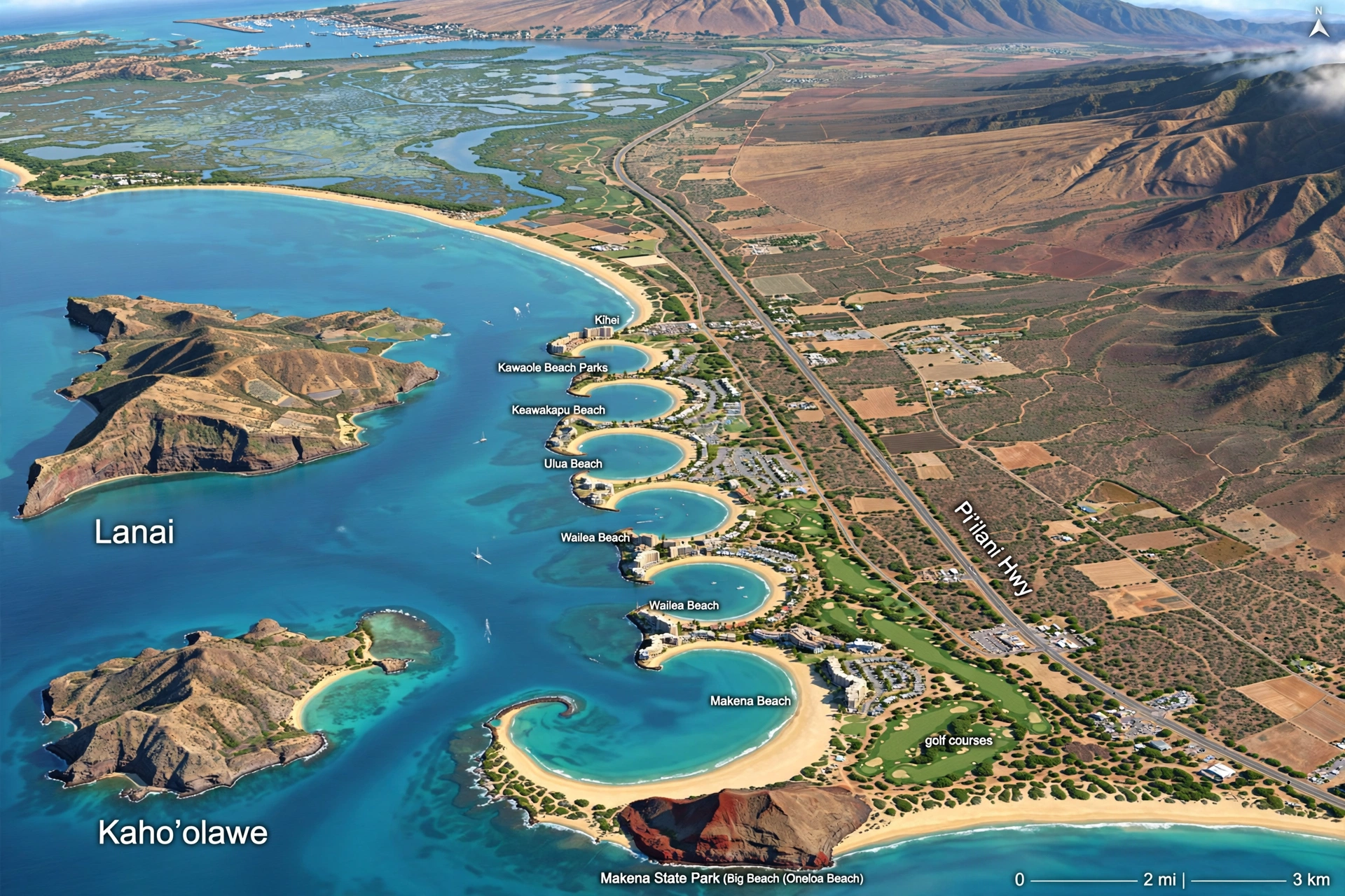
On most visitor maps, Kīhei is shown as a single town, but it functions as a string of connected districts rather than a compact downtown. There is no single historic town center. The commercial heart sits around the middle of the strip, near the Kamaʻole beach parks, while the northern and southern ends feel more residential. Understanding this linear geography is the key to navigating the town without confusion.
Historically, much of what is now Kīhei was wetland and marsh. The Kealia Pond National Wildlife Refuge at the town’s northern edge preserves a remnant of those wetlands, and old maps of the area show a landscape of fishponds and taro fields long before condominiums lined the shore. The Kōʻieʻie Fishpond at Kalepolepo is one surviving piece of that history, visible right from the coastal road.
Offshore, the map tells another part of the story. From almost anywhere along Kīhei’s shoreline, three islands sit on the horizon: Lānaʻi to the west, the uninhabited Kahoʻolawe to the southwest, and the small crescent of Molokini between them. Molokini, a partially submerged volcanic crater, is one of Maui’s most famous snorkeling destinations, and its distinctive half-moon shape is easy to pick out on calm mornings. The channels between these islands, the ʻAlalākeiki and the ʻAuʻau, are the waters that Kīhei’s beaches face, and they explain why the town’s surf stays gentle while the island’s north shore pounds.
For trip planning, Kīhei’s position matters. It is roughly 15 miles from Kahului Airport, about a 25 to 35 minute drive depending on traffic. It sits midway between the airport and the Wailea resort area, which makes it a practical base for exploring South Maui. The town also serves as the gateway to the southwest coast’s beaches, and its boat ramp provides ocean access toward Molokini and the island’s leeward waters.
Kīhei’s Layout: North to South
Reading Kīhei on a map is straightforward once you learn its north-to-south sequence. The town runs along a single coastal corridor, and its beaches, parks, and neighborhoods fall into a clear order. Here is the coastline from north to south.
North Kīhei: Māʻalaea to Kalepolepo
The northern end of Kīhei begins where the road leaves Māʻalaea and enters the long stretch of Sugar Beach. This is the widest, longest beach in the area, a sandy shoreline that runs for over a mile along North Kīhei Road. On a map, Sugar Beach forms the gentle northern arc of Kīhei’s coast, backed by the Kealia Pond wetlands just inland.
South of Sugar Beach, the coast continues past Kalepolepo Beach Park, a small county park known for the Kōʻieʻie Fishpond, an ancient Hawaiian fishpond whose stone walls are still visible in the shallows. Kalepolepo marks the transition from North Kīhei’s quieter residential stretches toward the busier central town.
North Kīhei is generally the least crowded part of town. The streets here are lined with older homes, small apartment buildings, and long-term rental properties rather than the dense condominium complexes found farther south. It is a good area for travelers who want Kīhei’s beaches without the town-center bustle.
Central Kīhei: The Kamaʻole Beach Parks
The middle of Kīhei is defined by the three Kamaʻole beach parks, numbered I, II, and III from north to south. On any Kīhei map, these are the landmarks everything else is measured against. Kamaʻole I sits near the town’s commercial core, Kamaʻole II lies a short walk south, and Kamaʻole III anchors the southern edge of central Kīhei.
Around the Kamaʻole parks, South Kīhei Road carries the town’s shops, restaurants, and services. This is the densest part of town, with shopping centers, grocery stores, and the highest concentration of condominiums. If someone says they are staying “in Kīhei,” they most often mean somewhere in this central band within walking distance of one of the three parks.
Between Kamaʻole I and II, the small pocket of Charley Young Beach fills a gap in the rocky shoreline. Just north of Kamaʻole I, Mai Poina Beach Park offers another small county beach. These in-between spots are easy to miss on a map but are part of the continuous beach chain that makes central Kīhei so walkable.
South Kīhei: Keawakapu to Wailea
South of Kamaʻole III, the coastline continues to Keawakapu Beach, a long sandy beach that runs to the Wailea boundary. Keawakapu is one of Kīhei’s most spacious beaches, popular with walkers, runners, and swimmers, and it marks the southern end of town.
Past Keawakapu, the shoreline enters Wailea, and the character changes from public beach parks and condos to resort landscaping. On the map, the transition is marked by the end of South Kīhei Road’s commercial strip and the beginning of Wailea’s manicured coastline. South Kīhei itself is largely residential, with quiet streets and larger properties set back from the beach.
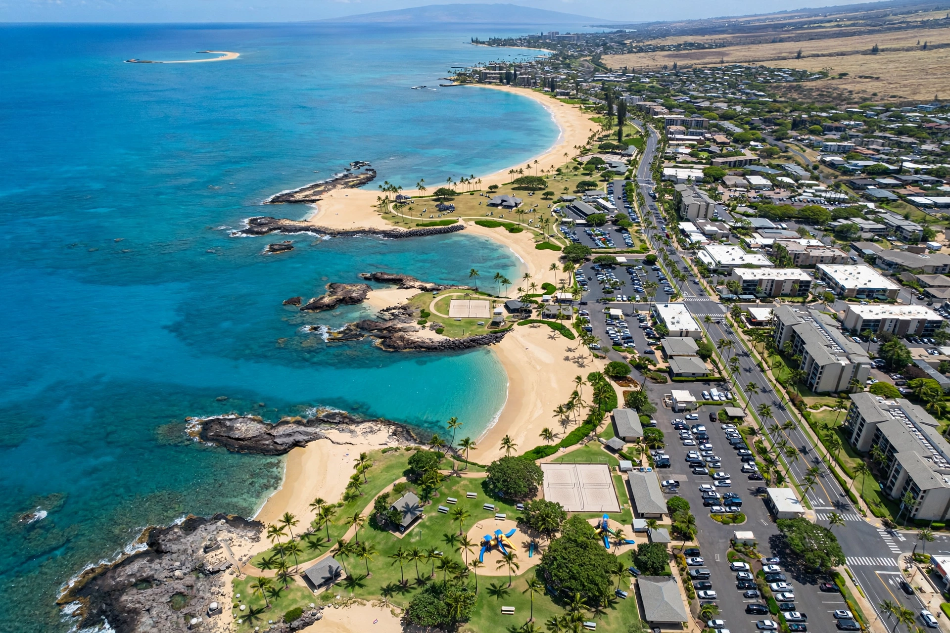
One useful way to picture the town: North Kīhei is the quiet residential end, central Kīhei is the beach-and-commercial core, and South Kīhei is the upscale residential transition toward Wailea. The whole strip is only about six miles long, so nothing in town is more than a fifteen-minute drive from anything else.
Key Roads Through Kīhei
Kīhei’s road network is simple, but knowing which road serves which purpose saves a lot of circling. Two parallel routes carry almost all of the town’s traffic.
South Kīhei Road and North Kīhei Road
The coastal road is the town’s main street. It is called North Kīhei Road at the northern end and South Kīhei Road through the central and southern sections. This is the slow, scenic route: speed limits are low, the road hugs the shoreline, and nearly every beach park, shop, and restaurant in town sits on or just off it.
If you are beach-hopping, stay on the coastal road. It passes every beach park in order, from Sugar Beach in the north to Keawakapu in the south, and the beach access points are clearly marked. Parking lots at the county beach parks fill early on weekends and holidays, so an early start matters.
Piʻilani Highway (Highway 31)
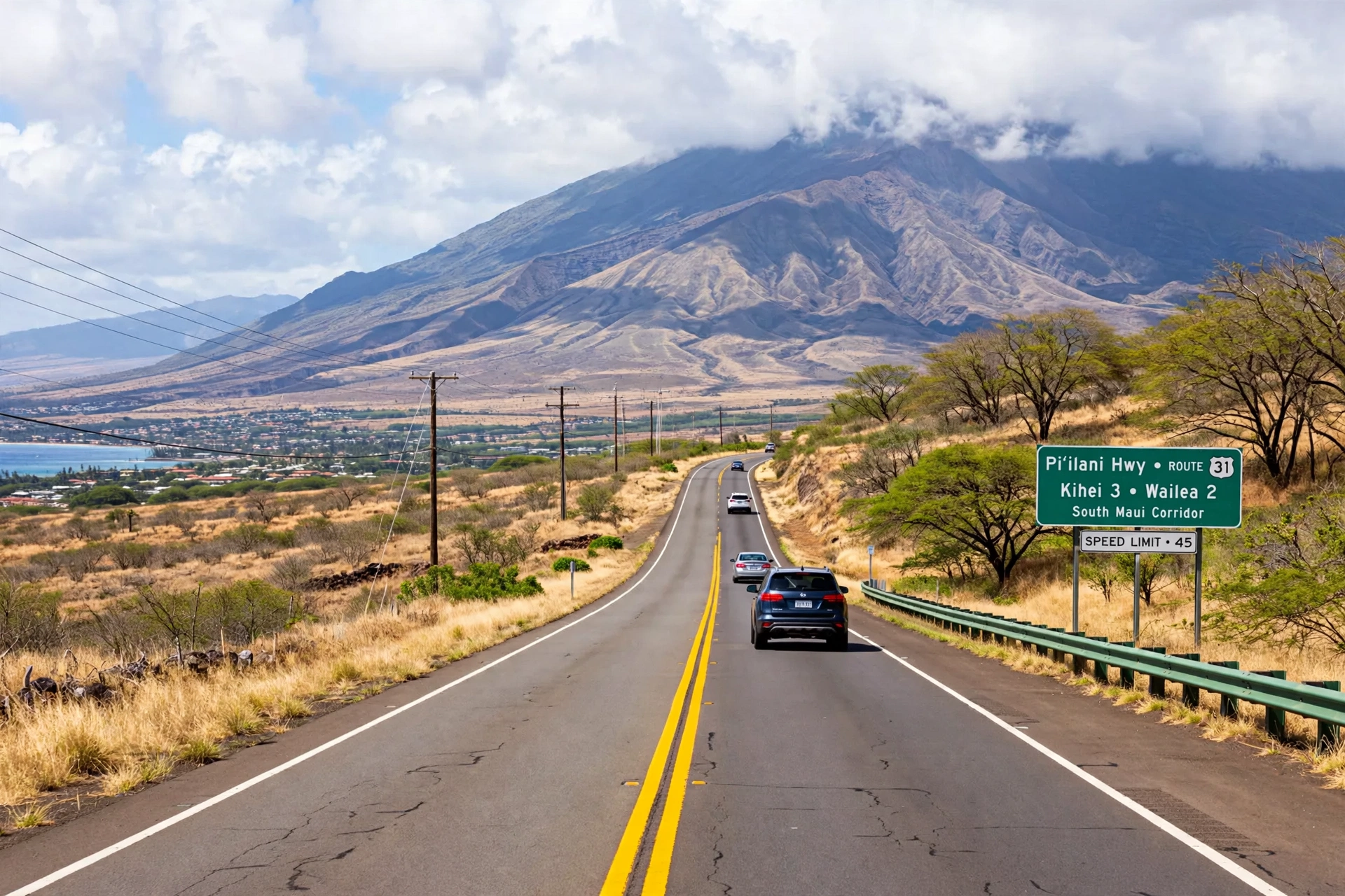
Running inland and parallel to the coastal road, the Piʻilani Highway is the fast route. It carries through traffic between central Maui and the Wailea and Mākena areas, bypassing Kīhei’s beachfront congestion. When you need to get from the airport to South Maui quickly, or from Kīhei to Wailea without stopping, the highway is the way.
The highway connects to the coastal road at several cross streets, so moving between the two is easy. Note that the Piʻilani Highway continues south past Wailea toward Mākena and eventually narrows into the road to La Perouse Bay, so it also serves as the route to South Maui’s wilder southern end.
Cross Streets and Connectors
Several east-west streets link the coastal road to the highway and to the neighborhoods in between. Līpoa Street, near the town center, is one of the busiest connectors. Ohukai Road serves the northern neighborhoods. Kaonoulu Street links central Kīhei to the highway and the areas around it. Waimāhaʻihai Street runs through the southern residential districts. Kenolio Road serves the area around Kalepolepo in the north.
From the airport, the standard route to Kīhei runs via the Mokulele Highway (Highway 311) from Kahului, which meets the Piʻilani Highway near the town’s northern end. The drive takes about 25 to 35 minutes in normal traffic. During morning and evening rush hours, the Mokulele Highway and the northern end of the Piʻilani Highway can slow down, so allow extra time.
Beaches on the Map
Kīhei’s beaches form one of the longest continuous sandy shorelines on Maui. Rather than isolated coves, the town offers a chain of beaches connected by the coastal road and, in places, by beachfront walking paths. Here is how they sit on the map, north to south.
Sugar Beach
At the northern end of town, Sugar Beach is a long, wide stretch of sand running along North Kīhei Road. It is the least developed of Kīhei’s beaches, with a wilder feel and fewer facilities than the Kamaʻole parks. The beach faces the channel toward the West Maui Mountains, and on clear days the views across the water are excellent.
Kalepolepo and the Fishpond
Kalepolepo Beach Park sits south of Sugar Beach, a small county park with the historic Kōʻieʻie Fishpond in its shallows. The pond’s stone walls, built centuries ago, are a reminder that this coast was worked and settled long before it was a beach destination. The park itself is modest, with a small sandy area and calm water.
Kamaʻole Beach Parks I, II, and III
The three Kamaʻole parks are Kīhei’s signature beaches. Kamaʻole I, the northernmost, has a broad sandy beach with lifeguards, restrooms, and a grassy park. Kamaʻole II is smaller and rockier at the edges, with good snorkeling along its reef borders. Kamaʻole III is the largest of the three, with a big grassy lawn, a playground, and a wide sandy beach. All three are county beach parks with parking, and all three draw the town’s biggest beach crowds.
For detailed coverage of each park’s swimming conditions, facilities, and access, see our Maui beaches guide, which covers the Kamaʻole parks and every other beach on the island in depth.
Charley Young and Mai Poina
Between Kalepolepo and Kamaʻole I, the shoreline holds two smaller spots worth knowing. Charley Young Beach, named for a local surfer, sits at the northern end of the Kamaʻole I stretch and offers a quieter patch of sand away from the main park crowds. Mai Poina Beach Park, just north of that, is a small county park with limited parking and a modest beach. Neither has the facilities of the Kamaʻole parks, but both appear on detailed Kīhei maps and give beachgoers options when the main parks are full.
Keawakapu Beach
At the southern end of Kīhei, Keawakapu Beach runs for nearly a mile to the Wailea border. It is one of the town’s best beaches for walking and running, with firm sand and a long, straight shoreline. The northern end near the Kīhei side has easier public parking, while the southern end blends into Wailea’s resort frontage.
Ocean Conditions and Safety
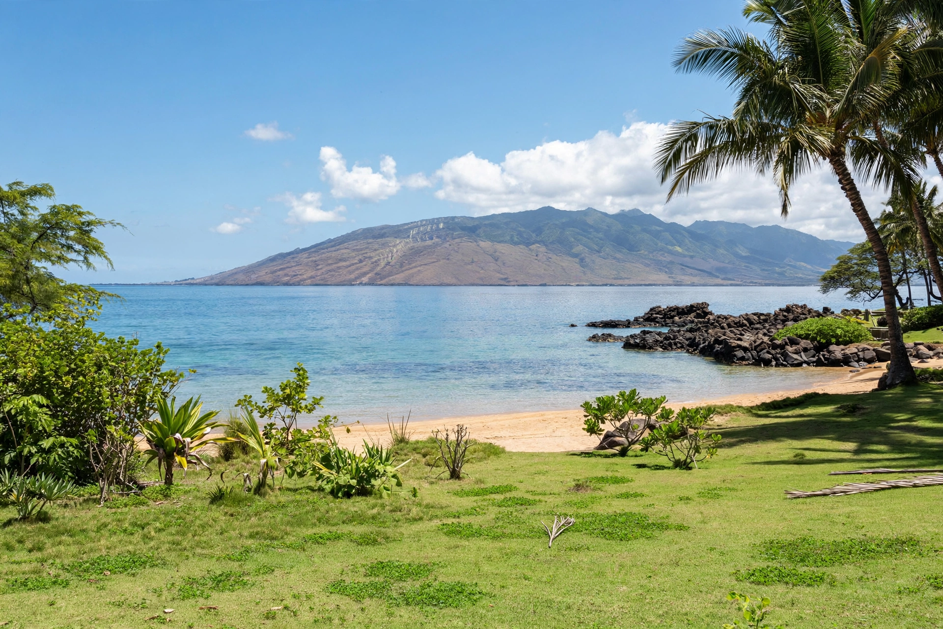
Kīhei’s beaches face southwest, which shelters them from the trade-wind swells that hit the island’s north and east shores. Summer brings occasional south swells that can raise surf heights, and winter is generally the calmest season. Conditions change daily, so check the lifeguard posts and posted ocean safety signs before swimming. County lifeguards staff the main beach parks, and their warnings about currents and surf should be followed without exception.
Neighborhoods and Areas
Beyond the beach chain, Kīhei’s neighborhoods spread inland between the coastal road and the Piʻilani Highway. Each has its own character.
North Kīhei Neighborhoods
The northern neighborhoods around Sugar Beach and Kalepolepo are the town’s oldest residential areas. Streets here hold a mix of plantation-era homes, modest houses, and small apartment buildings. The area has a local, lived-in feel, and it is where many of Kīhei’s long-term residents live. The Kealia Pond National Wildlife Refuge borders the district on the inland side, and its boardwalk offers birdwatching within minutes of the beach.
Central Kīhei
Central Kīhei, around the Kamaʻole parks and the Līpoa Street area, is the town’s commercial and visitor core. Condominium complexes line the streets between the coastal road and the highway, and the shopping centers along South Kīhei Road hold the town’s grocery stores, restaurants, and services. This is the most convenient area for visitors who want to walk to the beach, to dinner, and to daily errands.
South Kīhei and the Wailea Border
South of Kamaʻole III, the neighborhoods become quieter and more spread out. The streets around Waimāhaʻihai Street and toward Keawakapu hold larger homes and low-density complexes. The area feels suburban rather than touristy, and it appeals to travelers who want Kīhei’s beaches with more space and less foot traffic. At the southern edge, the town gives way to Wailea’s resort district.
Mauka (Inland) Kīhei
Between the coastal road and the Piʻilani Highway, and in pockets just mauka of the highway, Kīhei’s inland neighborhoods climb gently toward Haleakalā. These areas are almost entirely residential, with schools, churches, and community parks. They offer no ocean views, but they sit minutes from every beach in town and tend to be quieter and more affordable than beachfront streets.
Navigating Kīhei
Kīhei is one of the easiest towns on Maui to navigate, but a few practical notes help.
Orientation: The ocean is always to the west and southwest. If you keep the water on your right when driving south and on your left when driving north, you will not get lost. Haleakalā rises to the east, so the mountain is your inland landmark.
Parking: County beach park lots are free but fill early, especially at the Kamaʻole parks on weekends and holidays. Arrive before mid-morning for the best chance at a space. Street parking along South Kīhei Road is limited and signed, so read the signs carefully.
Traffic: South Kīhei Road moves slowly by design, with frequent crosswalks and turning traffic. Use the Piʻilani Highway for through trips and save the coastal road for beach access and browsing. Morning and evening commuter traffic affects the Mokulele Highway and the highway’s northern end.
Walking and biking: Central Kīhei is walkable, with sidewalks along much of South Kīhei Road and beachfront paths connecting several parks. The town is flat, which makes biking practical, and bike lanes appear on several streets. For longer trips, a car is still the practical choice.
Boat access: The Kīhei Boat Ramp, near the northern end of town, provides small-boat ocean access. Most Molokini snorkel cruises depart from Māʻalaea Harbor to the north, but some operators launch from the Kīhei area, so check departure points when booking ocean activities.
Frequently Asked Questions
Where is Kīhei located on Maui?
Kīhei is on Maui’s southwest coast, on the leeward side of Haleakalā. It stretches about six miles along the shoreline between Māʻalaea in the north and Wailea in the south, roughly 15 miles south of Kahului Airport.
Is Kīhei a good base for exploring Maui?
Kīhei works well as a South Maui base. It sits midway between the airport and Wailea, offers the island’s longest beach chain, and provides easy highway access to central Maui, Upcountry, and the Road to Hāna’s starting point at Pāʻia.
What are the Kamaʻole beaches?
Kamaʻole Beach Parks I, II, and III are three county beach parks in central Kīhei, numbered north to south. They are the town’s most popular beaches, with lifeguards, restrooms, parking, and sandy swimming areas.
How far is Kīhei from the airport?
Kahului Airport is about 15 miles from Kīhei, roughly a 25 to 35 minute drive via the Mokulele Highway and Piʻilani Highway in normal traffic.
Is Kīhei sunny year round?
Kīhei sits in Haleakalā’s rain shadow, making it one of Maui’s sunniest and driest towns. It receives far less rain than the island’s windward side, though brief winter showers do occur.
What is near Kīhei?
Māʻalaea and its harbor lie just north, Wailea and Mākena sit to the south, and Upcountry Maui (Kula, Makawao) is a short drive upslope to the east. Molokini crater lies offshore to the southwest.
Can you walk between Kīhei’s beaches?
Several of central Kīhei’s beaches connect via beachfront paths and short walks along South Kīhei Road, especially around the Kamaʻole parks. Walking the full six-mile chain is possible but long; most visitors walk sections.
Where do Molokini boats leave from near Kīhei?
Most Molokini snorkel cruises depart from Māʻalaea Harbor, just north of Kīhei, with some operators launching from the Kīhei Boat Ramp area. Check the departure point when planning a trip.
Related Guides
- Maui Towns: every town on the Valley Isle
- Maui Beaches: full beach coverage including the Kamaʻole parks
- Hawaiʻi Map: the statewide map hub
- Hawaiʻi Towns: towns across all islands
- Best Time to Visit Hawaiʻi: when to plan your trip
A Final Note
Kīhei rewards travelers who read its map before they arrive. The town’s linear geography means that a little orientation goes a long way: pick your end of the beach chain, learn the two parallel roads, and the whole of South Maui opens up from there. Whether you settle in for a week near the Kamaʻole parks or pass through on the way to Wailea, Kīhei’s sunny shoreline is one of the most approachable corners of Maui.