
Kauaʻi Hikes

Kauaʻi Hiking Overview
Kauaʻi is the oldest of the main Hawaiian Islands, and its age shows in the landscape. Millions of years of erosion have carved deep valleys, sheer sea cliffs, and some of the most dramatic hiking terrain in the Pacific. This is the Garden Isle, and its trail system reflects the nickname. Hikes here pass through rainforest so dense the canopy closes overhead, along knife-edge ridges above valleys that fall thousands of feet to the sea, and into the high bogs of the Alakaʻi Plateau, one of the wettest places on Earth.
Three regions define Kauaʻi hiking. On the north shore, the Nāpali Coast offers the island’s most famous trail, the Kalalau Trail, an eleven mile route along sea cliffs that ends at Kalalau Beach. Day hikers can walk the first two miles to Hanakāpīʻai Beach or continue another two miles inland to Hanakāpīʻai Falls, which is as far as day use goes. Every hiker on the Kalalau Trail beyond Hanakāpīʻai needs a camping permit, and every person entering Hāʻena State Park, where the trailhead sits, needs a reservation.
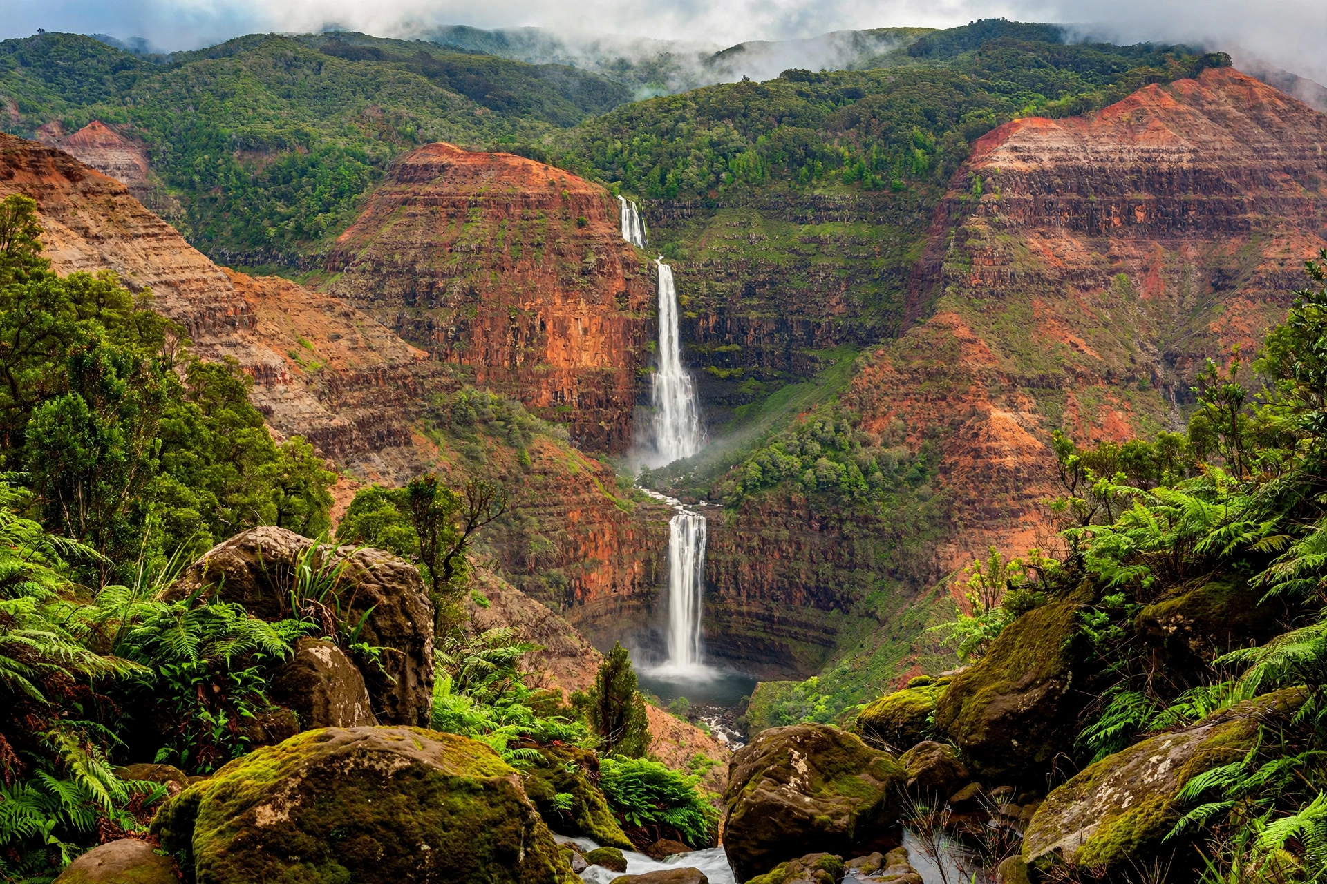
In the west, Waimea Canyon and Kōkeʻe State Park hold the island’s mountain trails. Waimea Canyon is often called the Grand Canyon of the Pacific, a ten mile long gorge up to 3,000 feet deep, colored in bands of red, brown, and green. Trails here descend into the canyon to waterfalls like Waipoʻo Falls or climb to overlooks above the Nāpali Coast, such as the Awaʻawapuhi and Nualolo trails. Kōkeʻe sits at 3,200 to 4,200 feet of elevation, where the air is cool and misty and the forest is full of native birds found nowhere else on Earth.
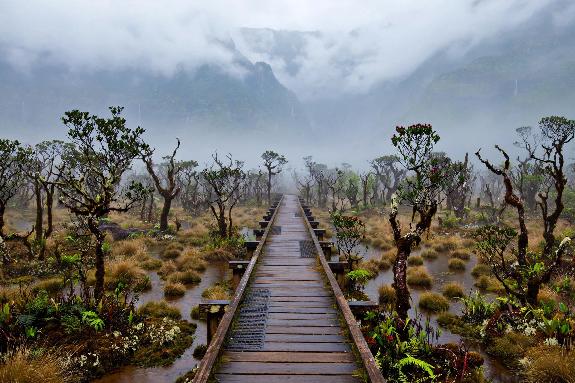
The third region is the Alakaʻi Plateau, home to the Alakaʻi Swamp Trail and the Pihea Trail. This is a montane bog, a landscape of stunted ʻōhiʻa trees, ferns, and boardwalk paths crossing open swampland with views into Waiʻaleʻale Crater, one of the rainiest spots on the planet. It is unlike anything else in Hawaiʻi and feels more like a hike in another world than a tropical island walk.
Elsewhere on the island, gentler trails suit families and casual walkers. The Sleeping Giant (Nounou Mountain) on the east side, the Kuilau Ridge Trail near Wailua, and the Mahaʻulepu Heritage Trail on the south shore all deliver real scenery without the commitment of the backcountry routes. Kauaʻi’s trail system is managed by a mix of agencies. Nā Ala Hele, the state’s trail program under the Division of Forestry and Wildlife, maintains most forest reserve trails. Hawaiʻi State Parks manages trails inside parks like Hāʻena and Kōkeʻe. Knowing which agency manages your trail matters, because permit rules, hours, and closures differ between them.

Top Hikes on Kauaʻi
Kalalau Trail
The Kalalau Trail is Kauaʻi’s most famous hike and one of the most celebrated coastal trails in the world. It runs eleven miles along the Nāpali Coast from Kēʻē Beach to Kalalau Beach, crossing five valleys and climbing from sea level to 800 feet and back down repeatedly. The full trail is a serious overnight backpacking route that takes most hikers two days each way. Day hikers are limited to the first four miles round trip to Hanakāpīʻai Beach, or eight miles round trip to Hanakāpīʻai Falls via the inland valley trail. Beyond Hanakāpīʻai, only permitted overnight campers may continue.
Even the day-hike section is demanding. The trail is narrow, uneven, and often muddy, with steep drop-offs in places. The reward is constant: sweeping views of sea cliffs, the lighthouse-green of Honopū Valley from the trail’s high points, and the wild beauty of Hanakāpīʻai Beach itself, where swimming is never safe. Access requires planning. Hāʻena State Park operates on a reservation system, and every visitor, hiker or not, needs an advance reservation for parking or shuttle entry. Overnight campers need a Kalalau camping permit from Hawaiʻi State Parks in addition to park entry. Both sell out, especially in summer.
Awaʻawapuhi Trail
Starting near the 17 mile marker of Kōkeʻe Road, the Awaʻawapuhi Trail descends about 1,600 feet over 3.1 miles through native forest to a pair of overlooks above the Nāpali Coast. The destination is a narrow ridge point where the land falls away on both sides, with Awaʻawapuhi and Nualolo valleys dropping to the sea below. On clear mornings the view stretches along the coast to the lighthouse-green amphitheater of Honopū. The return climb is the price of admission, and it feels long in the afternoon heat. Start early, carry more water than you think you need, and save this hike for a clear day, because clouds can erase the view entirely.
Canyon Trail to Waipoʻo Falls
This is the classic Waimea Canyon hike. The Canyon Trail leaves from the Puʻu Hinahina area and traverses the canyon rim before dropping to the top of Waipoʻo Falls, an 800 foot waterfall that plunges in tiers into the gorge. The round trip is about 3.5 miles with roughly 800 feet of elevation change. Parts of the trail cross bare red dirt that turns slick when wet, so footwear with real grip matters. The upper falls viewpoint, reached by a short side spur, is the highlight: you stand at the lip of the falls with the whole canyon opening below. Combine it with the nearby Cliff Trail for a longer loop along the rim.
Nāpali Overlook Trails: Nualolo and Pihea
Two Kōkeʻe trails deliver Nāpali views without the Kalalau commitment. The Nualolo Trail runs about 3.8 miles one way along the rim of Nualolo Valley to Lolo Vista Point, a broad overlook with the coast spread below. It can be combined with the Awaʻawapuhi Trail into a long loop via the Nualolo Cliff Trail for experienced hikers. The Pihea Trail starts at the Puʻu o Kila lookout at the end of Kōkeʻe Road and follows the rim of Kalalau Valley for about two miles to the Pihea Vista, with an optional continuation down into the Alakaʻi Swamp. Both are high elevation hikes where weather changes fast. If the lookouts at the road’s end are socked in with clouds, wait an hour. Kōkeʻe weather often clears by late morning.
Mahaʻulepu Heritage Trail
On the south shore near Poʻipū, the Mahaʻulepu Heritage Trail follows two miles of undeveloped coastline from Shipwreck Beach to Mahaʻulepu Beach. This is Kauaʻi’s last stretch of accessible wild coast on the south side, passing sea cliffs, lithified sand dunes, sinkholes, and the stone walls of an ancient Hawaiian village site. It is mostly flat and suitable for most fitness levels, though there is no shade and the trade winds can be strong. Go early or late in the day for the best light on the cliffs, and bring reef-safe sun protection. The trail is also one of the island’s best walks for spotting Hawaiian monk seals hauled out on the beaches, so keep the required distance and never approach them.
Sleeping Giant (Nounou Mountain)
The profile of Nounou Mountain on Kauaʻi’s east side resembles a giant lying on his back, and the Sleeping Giant Trail climbs to the “chest” for panoramic views of Wailua, Kapaʻa, and the coast. The main trail is about two miles each way with roughly 1,000 feet of elevation gain, winding through ironwood and guava forest. Near the top, a short unmarked scramble leads to the true summit rocks. Families often turn around at the picnic shelter viewpoint, which still delivers excellent views for less effort. The trailhead is in a residential area of Wailua, and parking is limited, so arrive early on weekends.
Kuilau Ridge Trail
Near the Keāhua Arboretum in the Wailua area, the Kuilau Ridge Trail is a gentle 2.2 mile round trip along a forested ridge with views into the Makaleha Mountains and across to Mt. Waiʻaleʻale. The path is wide and well graded, making it one of the island’s best options for families, trail runners, and anyone wanting rainforest scenery without a grueling climb. After rain it can be muddy, which is most of the time in this part of the island, so expect red dirt on your shoes. The arboretum at the trailhead is worth thirty minutes on its own, with labeled native and introduced trees.
Alakaʻi Swamp Trail
The Alakaʻi Swamp Trail is Kauaʻi’s strangest and most memorable hike. Starting from the Pihea Trail near the end of Kōkeʻe Road, it runs about 3.5 miles one way across the Alakaʻi Plateau, the largest high elevation swamp in Hawaiʻi. Much of the route is on boardwalk over open bog, past dwarfed ʻōhiʻa trees draped in moss, with native forest birds calling from the mist. The trail ends at the Kilohana Vista, an overlook platform with views into Waiʻaleʻale Crater. This is one of the wettest hikes in the islands. Waterproof footwear, rain gear, and a tolerance for mud are not optional. The birdlife is the real prize: ʻapapane, ʻamakihi, and with luck the endangered puaiohi have all been recorded along this route.
Wailua Area Trails
East side hikers have several shorter options around Wailua. The Wailua River area and nearby forest reserves hold easy walks like the Kuilau Ridge Trail described above, plus the short nature trails at the Keāhua Arboretum. For waterfall views without a long trek, the roadside overlooks of ʻŌpaekaʻa Falls and Wailua Falls are right off the highway, though the old trail down to the base of Wailua Falls is closed and dangerous and should not be attempted. These east side options work well as half day outings paired with the beaches and towns of the Coconut Coast.
Permits and Reservations
Kauaʻi has the most complex hiking permit system in Hawaiʻi, and understanding it before you arrive saves real disappointment. The rules come from two different agencies, so pay attention to which one manages your trail.
Hāʻena State Park, the gateway to the Kalalau Trail, operates on an advance reservation system managed by Hawaiʻi State Parks. Every person entering the park needs a reservation, whether arriving by private vehicle or by shuttle from Waipa. Day-use parking reservations and shuttle seats are released in advance and sell out quickly, particularly from May through September. Day hikers on the Kalalau Trail need only the park reservation for the Hanakāpīʻai sections. Anyone going beyond Hanakāpīʻai must hold an overnight camping permit for Kalalau, which also serves as park entry for the permit’s duration. Camping permits are limited, released on a rolling schedule, and extremely competitive. Book the moment your dates become available.
A few practical details make the Hāʻena system easier to navigate. Reservations are per person, not per group, and you choose between a parking reservation for a set entry window or a shuttle seat from Waipa, where parking is easier to find. If you miss your entry window, you may be turned away, so build in buffer time for the drive from Poʻipū or Wailua, which can take over an hour. Re-entry on the same reservation is allowed within your booked day, which matters if you want to rest at Kēʻē Beach after your hike. For overnight Kalalau permits, note that the permit covers a maximum stay, and rangers do check permits at the trailhead and at Hanakāpīʻai.
Trails in Kōkeʻe State Park and Waimea Canyon, including Awaʻawapuhi, Canyon Trail, Nualolo, Pihea, and the Alakaʻi Swamp Trail, do not require day-use reservations or hiking permits for day hiking. Overnight camping in Kōkeʻe does require a camping permit. Nā Ala Hele trails on forest reserve land, such as Kuilau Ridge and the Sleeping Giant, are generally open without permits for day use, though organized commercial groups need special use permits.
A final note on planning: Kauaʻi’s hikes pair naturally with the island’s regions, so it pays to group them geographically. Base north shore days around the Kalalau Trail and the Kēʻē area, west side days around Kōkeʻe and Waimea Canyon, and east side days around the Sleeping Giant, Kuilau Ridge, and Wailua. Driving between regions takes longer than the map suggests, especially with one-lane bridges and construction delays on Kūhiō Highway. Two hikes in one day are realistic only if they are short and close together, such as Kuilau Ridge plus the arboretum, or the Canyon Trail plus the Waimea Canyon lookouts.
Check for closures before every hike. Trails close for storm damage, rockfall, hunting seasons, and native bird nesting protections. The Division of Forestry and Wildlife and Hawaiʻi State Parks post closure notices on their official websites. The Kalalau Trail in particular has closed for extended periods after flooding and landslides. Never assume a trail is open because a guidebook says so.
Hiking Safety on Kauaʻi
Kauaʻi’s trails are beautiful and genuinely hazardous. The island’s rescue teams respond to hiking emergencies every year, and most incidents share the same causes. Knowing them in advance is the single most useful safety preparation you can do.
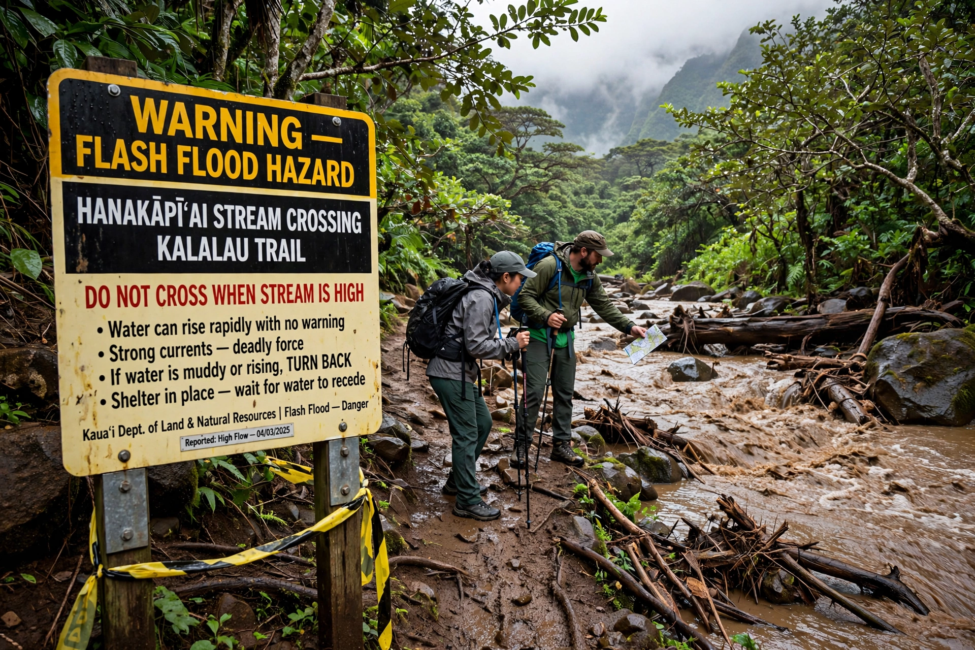
Flash floods are the number one killer. Kauaʻi’s north shore and interior receive enormous rainfall, and streams that look calm can rise several feet in minutes during a storm happening miles upstream. Never cross a flooded stream, and never camp in a dry streambed. The Hanakāpīʻai Stream crossing on the Kalalau Trail has claimed lives. If water is running high and brown, turn back. The Hanakāpīʻai Falls trail follows the stream inland and crosses it multiple times, so check the weather forecast for the entire watershed, not just the trailhead.
Mud is a constant. Kauaʻi’s red dirt and clay turn trails into slick channels after rain, and it rains somewhere on the island nearly every day. Trails along the Nāpali Coast and in Kōkeʻe are notorious for slippery footing. Wear shoes with aggressive tread, use trekking poles if you have them, and accept that you will get muddy. Ankle injuries from slips are among the most common reasons hikers need rescue.
Cliffs demand respect everywhere on this island. The Kalalau Trail traverses narrow sections with sheer drops, including the exposed stretch known as Crawler’s Ledge past Hanakāpīʻai. The overlooks at the ends of the Awaʻawapuhi and Nualolo trails are unfenced. Stay on the trail, keep children within arm’s reach at overlooks, and never step past barriers or warning signs for a photograph. Rockfall is a real hazard along cliff bases and in Waimea Canyon.
Heat, sun, and water catch visitors off guard. Kauaʻi feels cooler than it is when trade winds blow, and dehydration sneaks up on exposed ridge hikes like Awaʻawapuhi’s return climb. Carry at least two liters per person for a half day hike and more for full day routes. There is no reliable drinking water on any Kauaʻi trail. Stream water must be treated or filtered, and even then leptospirosis is a risk in Hawaiian streams, so avoid submerging open cuts and do not drink untreated water.
Ocean hazards apply at trail destinations. Hanakāpīʻai Beach and Kalalau Beach have powerful shore break, strong currents, and no lifeguards. People have drowned at both. Treat every beach at the end of a hike as look but do not swim unless it is a known safe swimming beach. Finally, tell someone your plan. Cell service disappears in valleys and along the Nāpali Coast. Leave your route and expected return time with someone reliable, and carry a headlamp even on day hikes. Kauaʻi’s dense forest gets dark early, and a delayed return should never become a night without light.
What to Pack
Kauaʻi hiking rewards hikers who pack for rain and mud even on sunny mornings. Start with footwear: trail shoes or hiking boots with deep lugs, already broken in. Road running shoes slide dangerously on Kauaʻi’s clay. Quick dry clothing beats cotton, which stays wet and cold in the island’s damp interior. A lightweight rain jacket or poncho belongs in your pack year round, especially for Kōkeʻe and the Alakaʻi, where afternoon showers are routine.
Water is non-negotiable. Bring at least two liters per person for half day hikes and three or more for full day routes like the Kalalau day hike or the Awaʻawapuhi round trip. Add salty snacks or electrolyte drinks, because you will sweat more than the breeze suggests. Sun protection matters even on overcast days: reef-safe sunscreen, a hat, and sunglasses.
Stream crossings deserve their own gear note. If your route includes the Hanakāpīʻai Stream or any valley stream, wear footwear that can get wet and still grip, and consider carrying a lightweight pair of water sandals so you are not hiking miles in soaked boots. A dry bag or waterproof stuff sack protects your phone, car key, and spare layers when rain arrives suddenly, as it often does on the north shore. In mosquito-prone lowland areas like the Wailua trails, long sleeves treated with permethrin or a strong repellent make the walk far more pleasant.
A basic first aid kit, blister treatment, insect repellent, and a headlamp round out the essentials. Trekking poles are worth their weight on the muddy descents of the Nāpali Coast trails. For the Kalalau overnight, add a water filter or purifier, a tent with a real rainfly, and a sleeping bag rated for cool mountain nights. Pack out everything you pack in. Kauaʻi’s backcountry has no trash service, and food waste harms the native wildlife.
Best Time for Hiking on Kauaʻi
Kauaʻi is a year round hiking destination, but the seasons matter. The drier season runs roughly April through September, with warmer temperatures and more stable trade wind weather. This is the best window for the Kalalau Trail, the Nāpali overlook hikes, and Waimea Canyon, when stream crossings are lower and mud is at its least punishing. It is also the busiest season, so Hāʻena reservations and Kalalau camping permits are hardest to get.
Elevation adds another layer to the timing question. Kōkeʻe sits above 3,000 feet, where mornings can dip into the 50s Fahrenheit even in summer, and the Alakaʻi is often ten degrees cooler than the coast with near constant mist. If you are hiking Kōkeʻe in winter, bring a warm layer for the viewpoints. Conversely, the south shore trails around Mahaʻulepu are hottest and driest from June through September, when the trade winds weaken and the sun is relentless. There is no bad month for those coastal walks, only hotter hours of the day to avoid.
The wetter season, October through March, brings bigger surf, more rain, and a higher chance of flash floods and trail closures. Winter storms can shut the Kalalau Trail for days. That said, Kōkeʻe’s waterfalls are at their most dramatic after rain, and the island is quieter outside the holidays. Whatever the season, start hikes early. Trade wind showers typically build in the afternoon, clouds often swallow the Kōkeʻe lookouts by midday, and an early start gives you the best light and the most margin if a hike runs long. Check the National Weather Service forecast for your specific region the morning of every hike, and be willing to swap a Nāpali hike for a south shore walk if the north shore is getting hammered.
Guided vs Self-Guided Hiking
Most Kauaʻi hikes are straightforward to do on your own with basic preparation. Trails like Kuilau Ridge, Sleeping Giant, Mahaʻulepu, and the Canyon Trail are well marked and manageable for self-guided hikers. A guide adds real value in specific cases: the full Kalalau Trail, where experienced local guides handle logistics and safety judgment; the Alakaʻi Swamp, where a naturalist guide can identify the native birds and plants you would otherwise walk past; and any hike where you are unsure about stream crossings or navigation. Guided hikes also solve the Hāʻena access puzzle, since some operators include permitted park entry. If you go self-guided on the serious routes, be honest about your fitness and experience. Kauaʻi’s backcountry is not the place to discover your limits. Either way, the preparation is the same: check official closure notices the night before, carry the ten essentials, and have a backup trail picked out. On Kauaʻi, the hikers who enjoy themselves most are the ones with a plan B.
Frequently Asked Questions
Do I need a permit to hike the Kalalau Trail?
For the day-hike sections to Hanakāpīʻai Beach and Hanakāpīʻai Falls, you need a Hāʻena State Park entry reservation but no hiking permit. To go beyond Hanakāpīʻai, you need an overnight Kalalau camping permit from Hawaiʻi State Parks, which also covers your park entry. No day hiking is allowed past Hanakāpīʻai under any circumstances.
How hard is the Kalalau Trail?
Very hard. The full eleven mile trail gains and loses thousands of feet across five valleys, with narrow cliff sections, stream crossings, and relentless mud. Even the eight mile round trip day hike to Hanakāpīʻai Falls is a strenuous full day. Train for it, start at dawn, and do not attempt it in questionable weather.
Can I hike Kauaʻi’s trails without a reservation?
Yes, for most trails. Only Hāʻena State Park requires advance reservations. Kōkeʻe, Waimea Canyon, and Nā Ala Hele forest trails like Sleeping Giant and Kuilau Ridge are open for day hiking without reservations, though overnight camping in Kōkeʻe needs a permit.
Is it safe to swim at Hanakāpīʻai Beach?
No. Hanakāpīʻai Beach has powerful shore break and dangerous currents with no lifeguard, and drownings have occurred there. Enjoy the beach from the sand and save swimming for a lifeguarded beach.
What is the best easy hike on Kauaʻi?
The Mahaʻulepu Heritage Trail and the Kuilau Ridge Trail are the best easy options, both under 2.5 miles with modest elevation gain and excellent scenery. The Sleeping Giant is the best short moderate hike with a big viewpoint payoff.
When do Kalalau camping permits become available?
Hawaiʻi State Parks releases Kalalau overnight permits on a rolling advance schedule through its official camping reservation system. They sell out fast for summer and holiday periods. Reserve the earliest your dates allow, and have backup dates ready.
Are Kauaʻi’s trails muddy year round?
Often, yes. The north shore, Kōkeʻe, and the Alakaʻi receive frequent rain in every month, and red clay trails stay slick for days after storms. Wear proper tread, expect mud, and consider gaiters or trekking poles in the wet season.
Can I see the Nāpali Coast without hiking the Kalalau Trail?
Yes. The Awaʻawapuhi, Nualolo, and Pihea trails in Kōkeʻe all end at overlooks above the Nāpali Coast, and the Kalalau Lookout at the end of Kōkeʻe Road offers the famous valley view from the road. Boat and helicopter tours also view the coast, but the overlook trails keep you on the hiking theme.
Related Guides
- Hawaiʻi Hikes: Complete Island-by-Island Guide
- Kauaʻi Map: Complete Island Guide
- Oʻahu Hikes: Complete Trail Guide
- Maui Hikes: Complete Trail Guide
- Hawaiʻi Beaches: Complete Guide
Kauaʻi rewards hikers who come prepared and stay flexible. Its trails cross some of the most dramatic terrain in the Hawaiian Islands, from the sea cliffs of the Nāpali Coast to the bogs of the Alakaʻi Plateau, and each region has its own weather, permits, and hazards. Plan around the reservation systems, respect the streams and cliffs, and build rest days into your itinerary so a rainy day becomes a detour rather than a disappointment. Hiked with care, the Garden Isle offers a lifetime of trails in a single visit.