
Hanalei Bay Map
On This Page
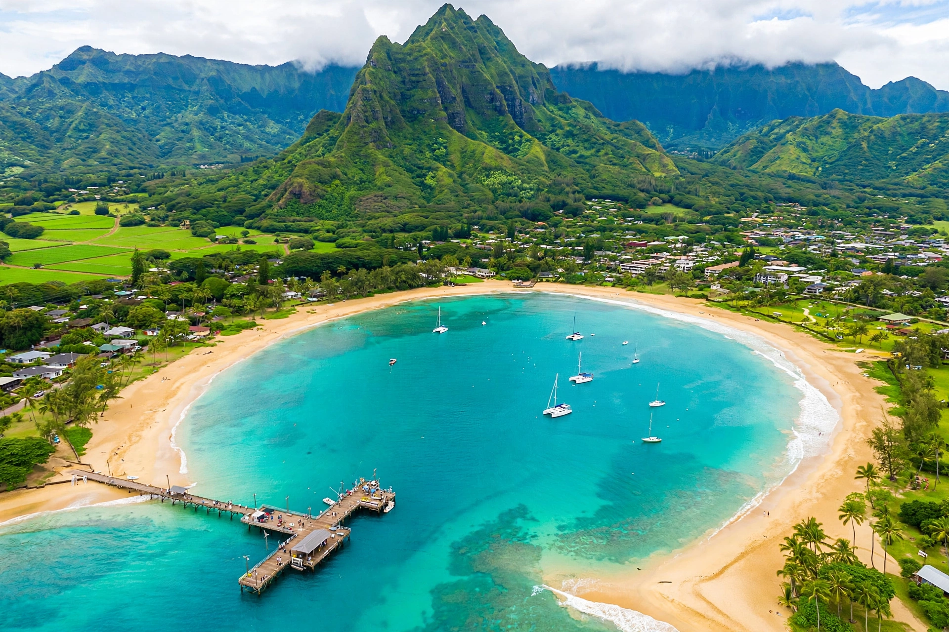
Hanalei Bay is the most photographed coastline on Kauaʻi and one of the most recognizable bays in all of Hawaiʻi. A crescent of golden sand stretches for nearly two miles along the island’s north shore, framed by the waterfall-lined peaks of Mount Makana, the mountain made famous in the film South Pacific as Bali Hai. This complete Hanalei Bay map guide walks you through the bay’s layout section by section, from the Hanalei River mouth and historic pier in the east to the quieter reaches of Waikokos in the west, so you can find the right beach, surf break, parking area and sunset spot for your visit.
Hanalei Bay at a Glance
Hanalei Bay sits on the north shore of Kauaʻi, between the resort town of Princeville to the east and the dramatic Nāpali Coast to the west. The name Hanalei is often translated as “lei valley,” a fitting description for a bay cradled by emerald ridgelines that drop straight into the sea. The bay faces north into the open Pacific, which explains why its mood changes so completely with the seasons. In summer, the ocean lies flat and glassy, sailboats anchor off the pier, and the water feels like a warm lake. In winter, north swells stack up against the offshore reef and the bay produces some of the best and most consistent surfing on the planet.
The bay’s shoreline runs from the mouth of the Hanalei River in the east to Puʻu Poa Point, the headland beneath the St. Regis (now 1 Hotel Hanalei Bay) in the west, a distance of just under two miles. Walking the full length of the beach takes about 45 minutes at an easy pace, and locals run and walk it every morning. A reef system at both ends of the bay creates natural boundaries, while the middle of the bay is open sand with a series of surf breaks that shift with the swell.
Behind the beach, Hanalei Valley spreads out in a patchwork of flooded taro fields that have been cultivated for centuries. More than 40 percent of Hawaiʻi’s taro is grown here, much of it within the Hanalei National Wildlife Refuge, a 917-acre sanctuary established on November 30, 1972, to protect endangered Hawaiian waterbirds including the aeʻo (Hawaiian stilt), ʻalae keʻokeʻo (Hawaiian coot), ʻalae ʻula (Hawaiian gallinule) and koloa (Hawaiian duck). The refuge itself is closed to the public, but the Hanalei Valley Lookout on Kūhiō Highway gives you a free, sweeping view over the fields and the birds they shelter.
The Historic Hanalei Pier
The single most recognizable feature on any map of Hanalei Bay is the pier that reaches 340 feet into the water at the bay’s eastern end. The original wooden pier was built before 1892 to unload goods arriving by inter-island steamer, and it became the shipping point for Hanalei’s rice industry. In the 1860s and 1870s, Chinese farmers who had finished their sugar plantation contracts converted taro fields into rice paddies, and by the early 1890s the Hanalei-Waiʻoli area was the largest rice-producing region in the kingdom.
The pier you see today is a reinforced concrete structure completed in 1912, a notably early use of that building method in Hawaiʻi. The wooden deck proved too difficult to maintain in the tropical climate, so the territorial legislature appropriated $25,000 in 1921 for a concrete deck, which contractors Conney and Morris finished in late 1922. A corrugated-iron shed roof was added at the far end in the 1940s. Shipping ended in 1933, and the pier became what it remains today: a community gathering place for fishing, swimming, sunset watching and jumping into the bay. It survived Hurricane ʻIniki in 1992, which heavily damaged it, and the pier’s canopy was restored in 2012 to 2013 with more than $170,000 raised by the Hanalei Rotary Club. The pier was listed on the National Register of Historic Places on September 13, 1979, and it appeared in the films Beachhead (1954) and South Pacific (1957).

Hanalei Bay Map: Layout, Breaks and Access Points
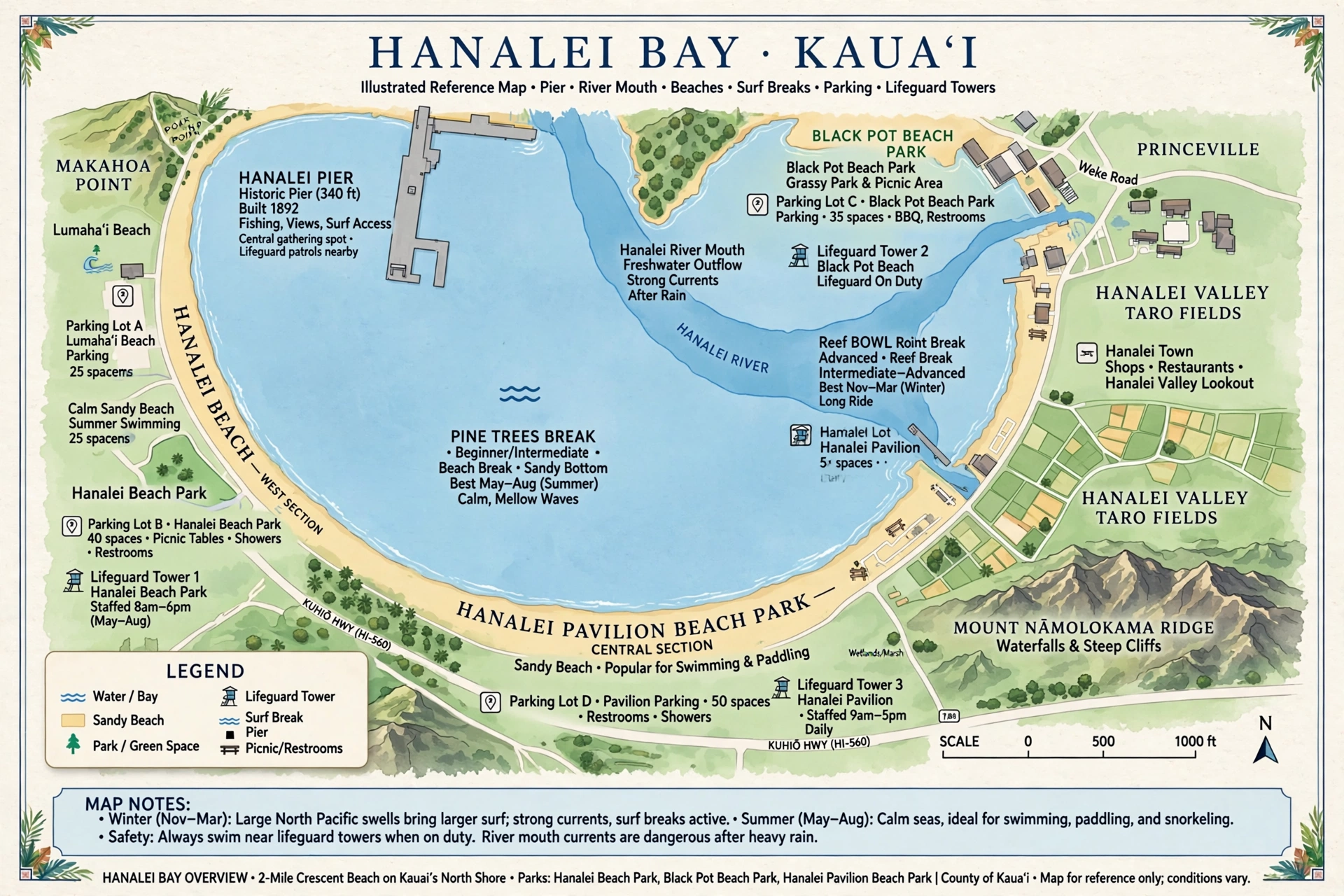
Understanding Hanalei Bay’s geography makes every part of your visit easier. Read the bay from east to west, river to headland, and each section has its own character, parking and surf.
Eastern End: Hanalei River Mouth and the Pier
The eastern anchor of the bay is the mouth of the Hanalei River, where fresh water meets the Pacific beside Black Pot Beach Park. The pier extends from this shoreline into the bay. Just offshore sits the surf break called The Point, a long right-hand point breaking over shallow reef to the east of the pier. The Hanalei River itself is a major feature: you can paddle a kayak or stand-up paddleboard about two miles upstream through tree-lined calm water as far as the Kūhiō Highway bridge. A public boat ramp at the river mouth serves recreational and commercial boats.
Mid-Bay: Hanalei Pavilion and Pine Trees
Moving west along the crescent, the next landmark is Hanalei Pavilion Beach Park, the bay’s central access point with the largest parking lot, restrooms, showers and picnic areas. West of the pavilion lies Waiʻoli Beach Park, known locally as Pine Trees for the ironwood trees that shade its grassy park. The Pine Trees surf break in front of the park is a beach break with generally mellow, beginner-friendly waves that can turn fast and hollow when a good swell and favorable wind arrive. Two lifeguard towers watch over this central stretch, and the surf tends to pick up between the pavilion and the second tower, so swimmers should check conditions before entering.
Western End: Waikokos and Puʻu Poa Point
The western end of the bay is Waikokos, the quietest and least developed section of shoreline. Here the beach narrows beneath Puʻu Poa Point, the headland that separates Hanalei Bay from the open coast toward the Nāpali. The Bowl, the bay’s heaviest and most expert-oriented break, works off this end of the bay, throwing hollow, powerful waves when winter swells arrive. Middles and the Sandbar are additional breaks along the western half. Access to Waikokos is via small neighborhood streets, and there is no large parking lot, which keeps crowds thin.
Reading the map for safety: Lifeguarded areas cluster around the pavilion and Pine Trees in the center of the bay. The outer reef at both ends of the bay is for experienced surfers only. In winter, when north swells run, swimming anywhere outside the calmest sections near the pier is risky. Check the lifeguard flags and posted surf advisories every day.
The Four Beaches of Hanalei Bay
Hanalei Bay is technically a single shoreline, but it is made up of four named beach areas running from west to east. Each has a different feel, and choosing the right one shapes your day.
Waikokos
The westernmost section of the bay is the locals’ end: narrower sand, fewer visitors, and the best vantage for watching expert surfers at The Bowl when the winter swell is up. There are no restrooms or lifeguards here, and parking is limited to small pullouts on neighborhood streets, so arrive early and keep noise low out of respect for residents. On calm summer days, Waikokos offers peaceful swimming and some of the bay’s best sunset views, with the sun dropping behind the headland.
Waiʻoli Beach Park (Pine Trees)
Waiʻoli, universally called Pine Trees, is the bay’s most beloved family park. Tall ironwood trees shade a grassy lawn with picnic tables, barbecue grills and restrooms, making it the top choice for a full beach day with kids. The swimming in front of the park is generally calm in summer, and the Pine Trees surf break just offshore is where many visitors catch their first-ever wave. This is the stretch of sand featured in countless photographs of the bay, with the mountains rising directly behind the beach.
Hanalei Pavilion Beach Park
The Pavilion is the bay’s main hub: the biggest parking lot, restrooms, outdoor showers, a large covered pavilion and two lifeguard towers. If you want the classic Hanalei beach day with the easiest logistics, start here. The sand is wide, the swimming is good in summer, and you can walk the beach in either direction, toward Pine Trees and the pier to the east or Waikokos to the west. Expect the most company here on weekends and holidays.
Black Pot Beach Park
At the bay’s eastern end, Black Pot Beach Park sits at the base of the pier beside the mouth of the Hanalei River. Its name comes from a big black iron pot once used to cook fish caught during hukilau, the traditional community net-fishing gatherings. A large grassy lawn hosts weekend picnics and, when camping is allowed, family campouts. The pier itself is the star: walk its 340-foot length, fish from the railing, or join the local tradition of jumping into the bay. Because the river makes the water near Black Pot brackish and sometimes murky, swimming is better a short walk down the beach, but the pier area is the calmest water in the bay and a fine place for tentative first-time surfers and paddleboarders in summer.

Surfing Hanalei Bay
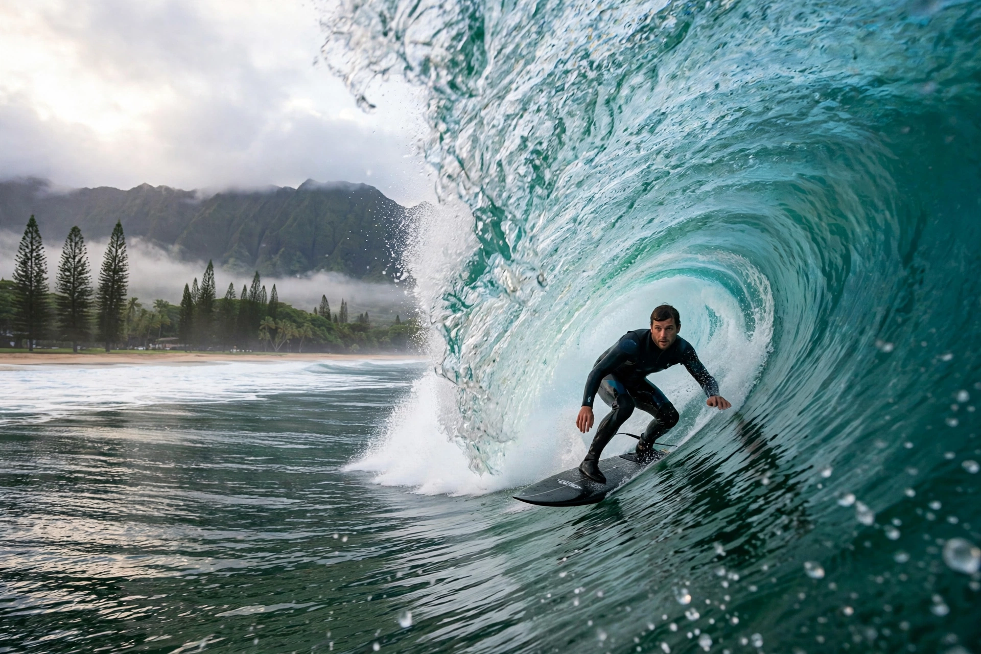
Hanalei Bay is sacred ground in surfing history. Andy Irons, the three-time world champion, and his brother Bruce Irons learned their craft on these waves, and the bay’s breaks have shaped generations of Kauaʻi surfers. The bay works on north swells, which means winter, roughly October through March, is prime season. Summer, from about May through September, is the calm season, when the bay goes nearly flat and beginners have the friendliest conditions of the year.
The Main Breaks, East to West
- The Point: the classic long right-hand point just east of the pier, breaking over shallow reef. It can run for up to 300 yards on a good swell and is best suited to experienced surfers because of the shallow reef.
- Pine Trees: the mid-bay beach break in front of Waiʻoli Beach Park. Generally mellow and beginner-friendly, but capable of fast, hollow barrels up to around 20 feet on the biggest winter swells. This is the break most visitors surf.
- Middles and the Sandbar: shifting sand-bottom peaks in the central and western bay that come and go with the swell and sand movement. Good intermediate options when they are working.
- The Bowl: the bay’s heavyweight break off the western end. Hollow, powerful and expert-only, The Bowl throws some of the most demanding waves on the north shore when a solid swell arrives.
- Outer reef: far offshore, an expert-only reef break that handles the largest swells of winter. Paddle-outs are long and conditions are serious.
Lessons, Rentals and Seasons
Surf schools operate at the calmer sections of the bay, particularly near the pier and Black Pot, where summer waves are small and forgiving. Board rentals are available from shops in Hanalei town and from stands near the beach in season. If you are learning, summer is your window: the ocean can feel like a lake, the wind is light, and the waves near the pier break gently over sand. If you are an experienced surfer chasing winter swells, check the surf forecast before you go, respect the local lineup, and never paddle out alone at the outer reef or The Bowl. Rip currents can form between the pavilion and Pine Trees when the surf rises, so even strong swimmers should ask the lifeguards about the day’s conditions.
Winter warning: From late fall through early spring, north swells can make the entire bay dangerous for swimming. Waves, shorebreak and rip currents intensify quickly. If the lifeguards post high-surf advisories, stay on the sand and enjoy the show. This is genuinely one of the great surf spectacles in Hawaiʻi, and watching a big day at The Bowl is worth the drive by itself.
Hanalei Town: Shops, Food and History
The town of Hanalei sits just inland from the bay along Kūhiō Highway, a single walkable strip you can cover end to end in about ten minutes. What it lacks in size it makes up for in character: historic plantation-era buildings house galleries, boutiques and surf shops, and the pace is unhurried even by Kauaʻi standards.
History is close to the surface here. The green-painted Waiʻoli Huiʻia Church, established in 1834, stands as one of the oldest church buildings in the islands, with stained-glass windows and a peaceful churchyard. Next door, the Waiʻoli Mission House preserves the story of the missionaries who arrived in the 1830s. In town, the Tahiti Nui restaurant and bar has been a local institution for decades, and the Ching Young Village shopping center anchors the west end of the strip with its landmark clock tower.
For food, Hanalei runs on casual island staples: plate lunches, poke bowls, fish tacos and food trucks serving the beach crowd. Shave ice is the essential afternoon stop after a morning in the sun. Galleries and craft shops along the highway sell work by local artists, from jewelry to paintings of the bay, at a scale you will not find in the resort areas to the south. Stock up on groceries, reef-safe sunscreen and beach supplies here before heading to the beach, since there are no large stores on the north shore beyond Princeville.

Driving to Hanalei Bay and Parking
Hanalei Bay is about a 45-minute drive from Līhuʻe Airport on the east side of the island, following Kūhiō Highway (Routes 56 and 560) north through Kapaʻa and Princeville. The drive itself is part of the experience: the highway crosses a series of one-lane bridges as it leaves Princeville and descends toward Hanalei, and the Hanalei Valley Lookout pullout about two miles before town is worth a stop for its view over the taro fields.
Where to Park
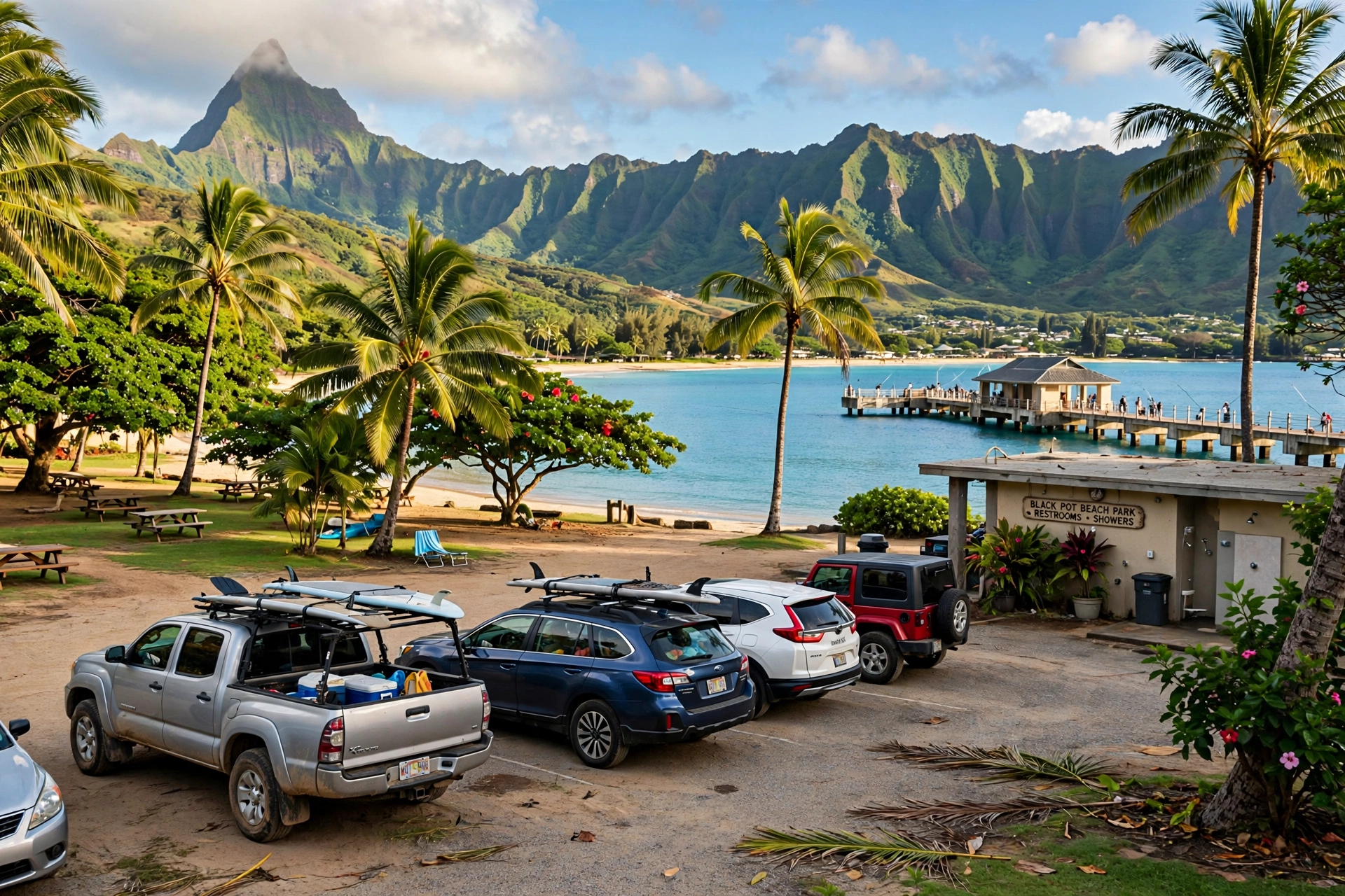
- Black Pot Beach Park: a dedicated lot at the end of Weke Road near the pier. Reach it by turning off Kūhiō Highway onto Aku Road, then right onto Weke Road and following it to the end. This lot fills early on weekends; side-street parking is available nearby when it does.
- Hanalei Pavilion Beach Park: the largest beach parking lot on the bay, with the most reliable availability. Good default choice if you want restrooms, showers and lifeguards close by.
- Waiʻoli Beach Park (Pine Trees): a smaller lot that fills quickly on sunny days. Arrive before mid-morning in summer for the best chance of a spot.
- Waikokos: street parking only on neighborhood roads. Keep it legal, keep it quiet, and never block driveways.
A few practical notes for the drive: the one-lane bridges on Route 560 require yielding to oncoming traffic, and local drivers expect you to know the protocol, so slow down and watch for the yield signs. Cell service can be spotty on the far north shore. Fill your gas tank and buy groceries before leaving Princeville, because options narrow considerably past Hanalei. If you are continuing west to Hāʻena State Park or the Kalalau Trail, note that Hāʻena requires advance reservations for entry or parking, so plan that separately.
Nearby Beaches: Lumahaʻi, Miloliʻi, Polihale and Keālia
Hanalei Bay sits in the middle of some of Kauaʻi’s most storied coastline, and visitors often ask about the beaches whose names appear alongside it in search results. Here is how each one relates to Hanalei Bay and what to know before you go.
Lumahaʻi Beach
Lumahaʻi Beach lies just west of Hanalei town along Route 560, about five minutes by car from the bay. It is a beautiful but deceptive beach: two coves of golden sand backed by ironwood trees, with strong currents and a powerful shorebreak that make swimming dangerous most of the year. Visitors search for it as “tourist Lumahaʻi” because it appeared in the film South Pacific, but treat it as a look-but-don’t-swim beach. Park in the small roadside pullouts, enjoy the view, and save your swimming for Hanalei Bay.
Miloliʻi Beach and Miloliʻi Beach Park
Miloliʻi is one of the most remote beaches on Kauaʻi, tucked into the Nāpali Coast far west of where the road ends at Keʻe Beach. There is no road access: you reach Miloliʻi only by permitted boat tour or by hiking the Kalalau Trail, an 11-mile one-way trek that requires a camping permit past Hanakāpīʻai. It is not a day trip from Hanalei Bay, and it should not be attempted without proper permits, preparation and respect for the area’s cultural significance.
How to Get to Polihale Beach
Polihale State Park, home to the longest beach in Hawaiʻi at 17 miles of white sand, sits on Kauaʻi’s far west side, roughly an hour’s drive from Hanalei Bay. From Hanalei, take Kūhiō Highway south and west through Waimea, then turn toward the coast on the unpaved Polihale access road, about five miles of dirt and sand that demands a high-clearance vehicle and dry weather. The effort is rewarded with enormous dunes, views of the Nāpali Coast’s southern end, and sunsets over Niʻihau. Bring everything you need, including water and shade, because there are no services at the park.
Keālia Beach
Keālia Beach is on Kauaʻi’s east coast near Kapaʻa, about 20 to 25 minutes southeast of Hanalei Bay. It is a long sandy beach with a boardwalk and bike path, popular with surfers and joggers. It makes a useful backup plan: when winter swells shut down swimming on the north shore, Keālia and the island’s east and south shores often stay calmer. If you were looking for a Kealia beach on the Big Island, note that the well-known Keālia Beach is on Kauaʻi; the Big Island’s major beaches have different names, and our Big Island beach guides cover those separately.

Hanalei Bay Map FAQ
Where exactly is Hanalei Bay on Kauaʻi?
Hanalei Bay is on Kauaʻi’s north shore, between Princeville to the east and the Nāpali Coast to the west. It is about a 45-minute drive from Līhuʻe Airport via Kūhiō Highway (Routes 56 and 560). The bay’s eastern end is marked by the Hanalei River mouth and the historic pier; the western end is Puʻu Poa Point.
How long is Hanalei Bay?
The beach crescent runs just under two miles from the Hanalei River mouth in the east to Puʻu Poa Point in the west. Walking the full length takes about 45 minutes at a relaxed pace.
What are the four sections of Hanalei Bay from west to east?
From west to east, the bay’s named sections are Waikokos, Waiʻoli Beach Park (called Pine Trees), Hanalei Pavilion Beach Park, and Black Pot Beach Park at the river mouth and pier.
Is Hanalei Bay safe for swimming?
In summer, yes, in the central and eastern sections, especially near the pavilion, Pine Trees and the pier, where lifeguards are posted. In winter, north swells can make the whole bay dangerous for swimming, with strong shorebreak and rip currents. Always check the lifeguard flags and daily surf advisories.
Where is the best place to park at Hanalei Bay?
Hanalei Pavilion Beach Park has the largest lot and is the most reliable choice. Black Pot Beach Park near the pier fills early on weekends. Waiʻoli (Pine Trees) has a small lot that fills by mid-morning in summer. Waikokos is street parking only.
Can beginners surf at Hanalei Bay?
Yes, in summer. The waves near the pier and at Pine Trees are small, sandy-bottomed and beginner-friendly when the north swells are absent. Surf schools operate in these sections. In winter, the bay’s breaks become powerful and are for experienced surfers only.
What is the story of Hanalei Pier?
The original wooden pier was built before 1892 to serve the rice industry’s shipping needs. The current 340-foot concrete pier was completed in 1912, with a concrete deck added in 1922. It was listed on the National Register of Historic Places in 1979, appeared in the films Beachhead (1954) and South Pacific (1957), was damaged by Hurricane ʻIniki in 1992, and had its canopy restored in 2012 to 2013.
How do you get to Polihale Beach from Hanalei?
Drive south and west around the island through Waimea, about an hour from Hanalei, then take the five-mile unpaved Polihale access road to the coast. A high-clearance vehicle and dry conditions are strongly recommended, and there are no services at the park, so bring water, food and shade.
Where is Lumahaʻi Beach relative to Hanalei Bay?
Lumahaʻi Beach is about five minutes west of Hanalei town along Route 560. It is scenic but has dangerous currents and shorebreak, so it is best enjoyed from the sand rather than in the water.
What is the best time of day to visit Hanalei Bay?
Early morning offers the calmest water, the softest light on the mountains, and the easiest parking. Sunset is the bay’s signature moment, with the sun dropping behind the western headland and the pier silhouetted against the sky, but expect more company at the pier and Black Pot in the evening.
Related Guides
- Hawaii Map: Complete Reference Map & Area Guide
- Hawaii Snorkeling
- Hawaii Hikes
- Maui Beaches: The Complete Guide
- Maui Map: Complete Reference Map & Area Guide
Reading Hanalei Bay Like a Local
The best way to use a Hanalei Bay map is to stop treating the bay as a single beach and start reading it the way residents do: river and pier in the east for history and calm water, pavilion and Pine Trees in the middle for the classic beach day, Waikokos in the west for quiet and big-wave watching. Match your section to the season, summer for swimming and learning to surf, winter for watching the Pacific at its most powerful, and the bay will give you exactly the day you came for. Few places in Hawaiʻi reward a little orientation as richly as this two-mile crescent beneath the mountains.