Where Is Hawaii Located?

Hawaii is located in the central North Pacific Ocean, about 2,400 miles southwest of California. It is the only US state situated outside North America, a chain of volcanic islands sitting roughly halfway between North America and Asia. If you searched “dónde está ubicado Hawái,” the short answer is: en el medio del océano Pacífico, al suroeste de California.
This is the single complete guide to where Hawaii is located. It covers the exact position, coordinates, distances from major cities, which continent Hawaii belongs to, the eight main islands, common misconceptions, and FAQs. If you have been searching for anything about where Hawaii is on the map, the answers are all here on this one page.
The Short Answer: Hawaii’s Position
Hawaii sits at roughly 20 degrees north latitude and 156 degrees west longitude, in the tropics of the central Pacific, about 1,470 miles north of the equator. Honolulu, the state capital on Oahu, is about 2,392 miles west southwest of San Francisco and about 3,850 miles east of Tokyo. The islands are the exposed peaks of a massive volcanic mountain chain rising from the ocean floor, and they are the most isolated population center on Earth, more than 2,000 miles from the nearest continent.
How Far Hawaii Is from Major Gateways
Distance is the best way to understand Hawaii’s location. The table below shows how far the islands sit from the cities most travelers fly from. Distances are great-circle approximations; flight times reflect typical published nonstop schedules and vary by airline, aircraft, and winds.
| Gateway city | Direction from Hawaii | Approx. distance | Typical nonstop flight |
| Los Angeles | Northeast | About 2,550 miles | About 5.5 hours |
| San Francisco | Northeast | About 2,390 miles (per Hawaii Data Book) | About 5 hours |
| Seattle | Northeast | About 2,680 miles | About 5.5 hours |
| New York | Northeast | About 4,970 miles | About 10 to 11 hours, usually one stop |
| Tokyo | Northwest | About 3,850 miles | About 7.5 to 8 hours |
| Sydney | Southwest | About 4,540 miles | About 9.5 to 10 hours |
The pattern is the point: Hawaii is far closer to the US West Coast than to Asia or Australia, which is why most visitors arrive from California. The islands sit almost exactly between North America and Asia, a position that made them a vital mid Pacific stopover for ships, then aircraft, then undersea cables.
How Hawaii Got to the Middle of the Ocean
Hawaii exists because of a volcanic hotspot, a plume of hot rock rising from deep in the Earth. As the Pacific tectonic plate drifts northwest over the hotspot at a few inches per year, magma punches through the plate and builds volcanoes. Each island formed over the hotspot in turn, then went quiet as the plate carried it away. That is why the islands march in age order: Kauai, in the northwest, is about 5 million years old, while the Big Island, in the southeast, is still growing today with active volcanoes.
The hotspot is still there, under the Big Island’s southeast coast. The next Hawaiian island, already named Kamaʻehuakanaloa, is growing on the seafloor off the Big Island and will break the surface in tens of thousands of years. The chain continues far beyond the main islands: the Northwestern Hawaiian Islands and the Emperor Seamounts trail thousands of miles toward Russia, a fossil record of 80 million years of the plate moving over the same hotspot.
Hawaii’s Neighbors in the Pacific
Because Hawaii is so isolated, its “neighbors” are far away by any normal standard. To the south, the nearest island groups are in French Polynesia, about 2,700 miles away, and the Line Islands of Kiribati, with Kiritimati roughly 1,300 miles south. To the north, Alaska is about 2,800 miles away. To the west, beyond the long Northwestern Hawaiian Island chain, the vast open Pacific stretches more than 3,000 miles to Japan.
This isolation is why Hawaii is often called the most remote island group on Earth. No other major population center is as far from a continent. The upside is a mild, stable climate and an ecosystem that evolved in seclusion. The downside, for travelers, is that there is no cheap or quick way to arrive. Every visitor comes by air or, rarely, by sea, and everything from rental cars to restaurant ingredients arrives the same way.
Which Continent Is Hawaii On?
Hawaii belongs to Oceania, the continent sized region covering the Pacific islands, and more specifically to Polynesia, the triangle of island cultures stretching from Hawaii to New Zealand to Easter Island. Politically it is the 50th US state, admitted in 1959, but geographically it has nothing to do with North America. The islands sit on the Pacific tectonic plate, slowly drifting northwest a few inches per year over a volcanic hotspot that built them.
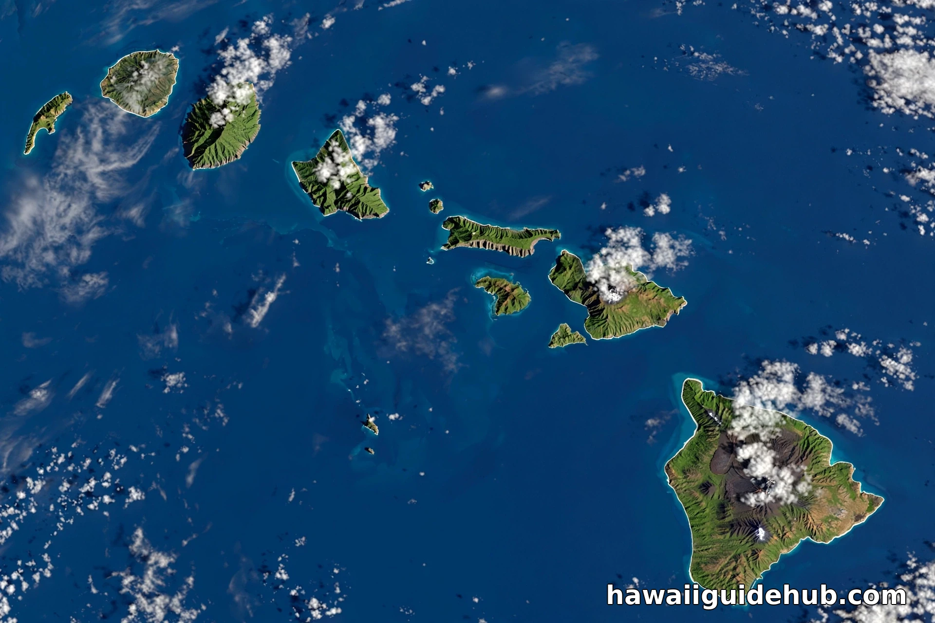
The state actually includes far more than the eight main islands most people picture. The full Hawaiian archipelago stretches about 1,500 miles northwest and includes 137 islands and atolls, most of them tiny and uninhabited, protected within the Papahānaumokuākea Marine National Monument. The eight main islands, from oldest to youngest in geologic terms, are Niihau, Kauai, Oahu, Molokai, Lanai, Kahoolawe, Maui, and the island of Hawaii, the Big Island.
What Hawaii’s Location Means for Visitors
Location shapes everything about a Hawaii trip. The islands run on Hawaii-Aleutian Standard Time, UTC minus 10, with no daylight saving, so they are 2 to 3 hours behind the US West Coast and 5 to 6 hours behind the East Coast depending on the season. Flights from the mainland West Coast take about 5 hours, which makes Hawaii the shortest true tropical escape from California. From the East Coast or Europe, it is a full day of travel.
The tropical latitude, around 20 degrees north, is why Hawaii’s weather is so consistent. Temperatures sit in the 70s and 80s Fahrenheit nearly all year, with the trade winds keeping things comfortable. Being north of the equator means Hawaii’s seasons match the mainland’s, winter is the wetter season, unlike destinations south of the equator where everything flips. If you are timing a trip, our guides to the cheapest time of year to visit Hawaii and what time of year it rains in Hawaii will help.
Isolation has a practical side too. Nearly everything is shipped or flown in, which is why groceries, gas, and hotel rates run higher than on the mainland. It is also why the islands have so many species found nowhere else on Earth. Choosing which island fits you best matters more here than in most destinations, so see our guide to the best island in Hawaii for first time visitors before you book.
Location also explains Hawaii’s outsized strategic role. Sitting mid Pacific, the islands became the key American outpost between the mainland and Asia, which is why Pearl Harbor on Oahu was the target of the 1941 attack that brought the US into World War II. Joint Base Pearl Harbor Hickam remains one of the most important US military installations in the Pacific, and the history is visible to visitors at the Pearl Harbor National Memorial.
For travelers, the practical takeaway is simple. Hawaii is American soil with an Asian Pacific soul, reachable on a domestic flight, using dollars and English, yet culturally and geographically a world apart from the mainland. That combination is exactly why it draws nearly 10 million visitors in a typical year.
Common Misconceptions About Where Hawaii Is
The most common mix up is placing Hawaii near the Caribbean or off the coast of Florida, probably because US maps tuck it into a corner inset. It is nowhere near the Atlantic. Another frequent question is whether Hawaii is close to Japan. It is not especially close: Tokyo is about 3,850 miles away, roughly 1,400 miles farther than California. Hawaii is also not “in” Asia, not part of any other country, and not a territory. It is a full US state with two senators, four electoral votes, and the only royal palace in the United States, Iolani Palace in Honolulu.
People also underestimate the distances between the islands themselves. Oahu to the Big Island is about 200 miles, and inter island flights take 30 to 45 minutes. You cannot drive between islands, and the ferries that once connected Maui and Lanai no longer run for regular passengers. Plan your island hopping by air.
A subtler misconception is that Hawaii is a single island. “Hawaii” is both the state and the Big Island, and mixing them up causes real booking mistakes, like reserving a hotel on the wrong island. Always check which island your flight, hotel, and activities are on. Another is assuming the islands are tiny and quick to explore. The Big Island alone is larger than all the other main islands combined, and driving around it takes the better part of a day.
¿Dónde Está Ubicado Hawái?
Hawái está ubicado en el océano Pacífico central, aproximadamente a 3,860 kilómetros al suroeste de California, Estados Unidos. Es el único estado de EE. UU. que se encuentra en Oceanía, en la región de Polinesia. Sus coordenadas son aproximadamente 20 grados de latitud norte y 156 grados de longitud oeste. El vuelo desde Los Ángeles dura unas 5 horas y media.
Video: Where Is Hawaii on the Map?
A visual tour of Hawaii’s position in the Pacific and a walkthrough of each of the main islands.
Frequently Asked Questions
Where is Hawaii located exactly?
Hawaii is in the central North Pacific Ocean at about 20°N, 156°W, roughly 2,400 miles southwest of California and about 2,550 miles southwest of Los Angeles. It is the only US state in Oceania.
Is Hawaii closer to California or Japan?
California, by a wide margin. Hawaii is about 2,400 miles from California and about 3,850 miles from Japan.
What continent is Hawaii in?
Oceania, specifically the subregion of Polynesia. Politically it is the 50th US state, but geographically it is not part of North America.
How many islands does Hawaii have?
The state includes 137 islands and atolls across a 1,500 mile archipelago, but only eight main islands, six of which are open to visitors.
Is Hawaii near the Caribbean?
No. Hawaii is in the Pacific Ocean, thousands of miles from the Caribbean, which is in the Atlantic. The confusion comes from US map insets.
What time zone is Hawaii in?
Hawaii-Aleutian Standard Time, UTC minus 10, with no daylight saving time. It is 2 to 3 hours behind the US West Coast.
Can you drive from California to Hawaii?
No. There is no bridge, tunnel, or road connection. The only practical way to reach Hawaii is by air, about 5 hours from the US West Coast. Cruise ships also sail to the islands from California and take several days.
What is the capital of Hawaii and where is it?
Honolulu, on the island of Oahu. It sits on Oahu’s south shore at about 21°N, 158°W and is home to roughly two thirds of the state’s population.
How long does it take to fly to Hawaii?
About 5 to 5.5 hours nonstop from the US West Coast, 8 to 10 hours from the East Coast with a connection, and about 8 hours from Tokyo. There are no nonstop flights from Europe.
¿Dónde está ubicado Hawái?
Hawái está en el Pacífico central, a unos 3,860 km al suroeste de California. Es un estado de EE. UU. ubicado en Oceanía, en la Polinesia.
Hawaii’s location is the whole story: a volcanic archipelago alone in the middle of the largest ocean on Earth, close enough to California for a five hour flight, yet remote enough to have grown a culture and an ecosystem found nowhere else. Once you see where it sits on the map, everything about the islands starts to make sense.